
Boyana Glacier in Levski Ridge, Tangra Mountains on Livingston Island, South Shetland Islands in Antarctica is situated southeast of Macy Glacier and west-southwest of Srebarna Glacier. It is bounded by Vazov Rock on the west, St. Naum Peak, Starosel Gate, Silistra Knoll and Kotel Gap on the north, and Christoff Cliff on the east. The glacier extends 3 km in east-west direction and 1.6 km in north-south direction, and flows southeastward into the Bransfield Strait between Vazov Point and Aytos Point.

Mesta Peak is a conspicuous, sharp and narrow rocky peak extending 500 m in east-west direction and rising to approximately 400 m in Delchev Ridge, Tangra Mountains, eastern Livingston Island in the South Shetland Islands, Antarctica. The peak has steep and ice-free slopes and surmounts the east extremity of Sopot Ice Piedmont to the north.

Murgash Glacier is the 3.4 km long and 3.2 km wide glacier on Greenwich Island in the South Shetland Islands, Antarctica situated southeast of Yakoruda Glacier, south of Teteven Glacier, southwest of Traub Glacier and west-northwest of Bravo Glacier. It is bounded by Lloyd Hill on the northwest, Tile Ridge on the east and Hebrizelm Hill on the southeast, and drains southwards into Kramolin Cove in McFarlane Strait between Yovkov Point and Kaspichan Point.
Musala Glacier on Greenwich Island in the South Shetland Islands, Antarctica is situated northeast of Targovishte Glacier, east-northeast of Zheravna Glacier and southeast of Fuerza Aérea Glacier. It is bounded by St. Kiprian Peak to the south, Vratsa Peak to the southwest, central Breznik Heights to the west, and Ilarion Ridge bordering Hardy Cove to the northeast, extends 2 nautical miles in east-west direction and 1.2 nautical miles in north-south direction, and drains eastwards into Bransfield Strait north of Fort Point.

Panega Glacier on Varna Peninsula, Livingston Island in the South Shetland Islands, Antarctica is situated southeast of the northeastern portion of Saedinenie Snowfield, south of Rose Valley Glacier, southwest of Debelt Glacier and north of lower Kaliakra Glacier. It drains the southeast slopes of Vidin Heights and flows into Moon Bay between Helis Nunatak and Perperek Knoll. The glacier extends 2 nautical miles in the southeast-northwest direction, and 1.6 nautical miles in the southwest-northeast direction. It is named after Zlatna Panega River in northern Bulgaria.

Pautalia Glacier is a small glacier on Burgas Peninsula, Livingston Island in the South Shetland Islands, Antarctica situated northeast of Strandzha Glacier and south of Sopot Ice Piedmont. It is bounded by Petko Voyvoda Peak to the west, Sozopol Gap to the northwest, Kaloyan Nunatak to the north and Shabla Knoll to the east. The glacier extends 700 m in northwest-southeast direction and 1.1 km in southwest-northeast direction, and flows southeastward into Bransfield Strait.
Radomir Knoll rises to approximately 300 m in Prespa Glacier, eastern Livingston Island in the South Shetland Islands, Antarctica. It is formed by the south extremity of an offshoot of Friesland Ridge, Tangra Mountains that extends to the south-southeast from St. Cyril Peak and surmounts Chavei Cove to the south and southwest.
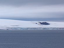
Rila Point is a low, ice-free point on the south coast of Moon Bay, projecting 330 m west-northwestwards from Burgas Peninsula on Livingston Island in the South Shetland Islands, Antarctica, and forming the east side of the entrance to Bruix Cove. The point is named after Rila Mountain, Bulgaria.
Shabla Knoll rises to over 400 m (1,312 ft) in Delchev Ridge, Tangra Mountains, Livingston Island in the South Shetland Islands, Antarctica surmounting Sopot Ice Piedmont to the north and Pautalia Glacier to the southwest.
Shopski Cove is a 2.6 km wide cove indenting for 1.9 km the southwest coast of Greenwich Island in the South Shetland Islands, Antarctica, between Triangle Point and the westernmost extremity of the moraine spit of Provadiya Hook protecting Yankee Harbour. Shape enhanced as a result of Bravo Glacier’s retreat in the late 20th and early 21st century. The area was visited by early 19th century sealers operating from Yankee Harbour.
Silistra Knoll rises to over 700 m (2,297 ft) in southern Levski Ridge, in the Tangra Mountains of Livingston Island in the South Shetland Islands, Antarctica. It is bounded by Macy Glacier to the north and Boyana Glacier to the south.

Sliven Peak rises to 530 m in the east extremity of Melnik Ridge, Livingston Island in the South Shetland Islands, Antarctica. The peak has precipitous rocky southern slopes and partly ice-free northern slopes, overlooking Kaliakra Glacier to the northwest and Struma Glacier to the south and east.

Spanish Knoll has a highest point of elevation 48 m located on Bulgarian Beach on Hurd Peninsula, eastern Livingston Island in the South Shetland Islands, Antarctica.

Svoge Knoll is an ice-covered peak rising to 560 m in Bowles Ridge, Livingston Island in the South Shetland Islands, Antarctica. Surmounting Perunika Glacier to the south and west.
Teteven Glacier is a glacier on Greenwich Island in the South Shetland Islands, Antarctica situated east of Yakoruda Glacier, west of Quito Glacier, northwest of Traub Glacier and north of Murgash Glacier. It extends 6.5 km in east-west direction and 3.8 km in north-south direction, and drains the north slopes of Dryanovo Heights into the Drake Passage in Haskovo Cove and Skaptopara Cove between Miletich Point and the ice-free area at Agüedo Point.
Wulfila Glacier is located on the southern slopes of Breznik Heights, Greenwich Island in the South Shetland Islands, Antarctica, south-southwest of Solis Glacier and west of Zheravna Glacier. It is bounded by Oborishte Ridge to the northwest, Nevlya Peak to the north, Terter Peak and Razgrad Peak to the northeast, and Ephraim Bluff to the southeast. The glacier extends 3 km in northwest-southeast direction and 2 km in northeast-southwest direction, draining southwestwards into McFarlane Strait between Ephraim Bluff and the base of Provadiya Hook.
Zemen Knoll is a peak of 453 m in the Vidin Heights on Varna Peninsula, Livingston Island in the South Shetland Islands, Antarctica. The knoll overlooks Kaliakra Glacier to the southeast, and Saedinenie Snowfield to the northwest and west. The feature is named after the town of Zemen in Western Bulgaria.
Balchik Ridge is a 1.3 km long narrow ridge in Tangra Mountains on Livingston Island in the South Shetland Islands, Antarctica with a highest point of 550m. The ridge adjoins the col linking Silistra Knoll and Peshev Ridge and surmounts Boyana Glacier to the southwest, south and east. The ridge was named after the Bulgarian town of Balchik.


