Spit Point (Greenwich Island)

Last updated
Location of Greenwich Island in the South Shetland Islands. Greenwich-Island-location-map.png
Location of Greenwich Island in the South Shetland Islands.
Provadiya Hook from Shopski Cove, with Spit Point at its left extremity and Oborishte Ridge in the background. Provadiya-Greenwich.JPG
Provadiya Hook from Shopski Cove, with Spit Point at its left extremity and Oborishte Ridge in the background.
Topographic map of Livingston Island, Greenwich, Robert, Snow and Smith Islands. Livingston-Island-Map-2010.jpg
Topographic map of Livingston Island, Greenwich, Robert, Snow and Smith Islands.

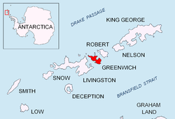
Spit Point ( 62°31′32″S59°47′18.5″W / 62.52556°S 59.788472°W / -62.52556; -59.788472 ) is a narrow gravel spit forming the south side of the entrance to Yankee Harbor, Greenwich Island, in the South Shetland Islands, situated at the end of Provadiya Hook. The point was known to early sealers in the area and roughly charted on Powell's map of 1822. It was recharted by DI personnel on the Discovery II in 1935 and given this descriptive name.

Maps

References


PD-icon.svg This article incorporates public domain material from "Spit Point (Greenwich Island)". Geographic Names Information System . United States Geological Survey.  OOjs UI icon edit-ltr-progressive.svg