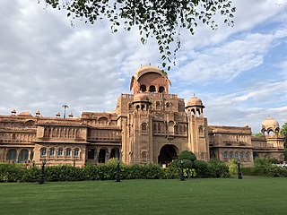
Bikaner is a city in the northwest of the state of Rajasthan, India. It is located 330 kilometres (205 mi) northwest of the state capital, Jaipur. Bikaner city is the administrative headquarters of Bikaner District and Bikaner division.

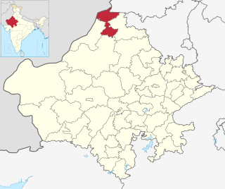
Bikaner District is a district of the state of Rajasthan in western India. The historic city of Bikaner is the district headquarters. The district is located in Bikaner Division along with the three other districts of Anupgarh, Sri Ganganagar and Hanumangarh.

Churu district is a district of the Indian state of Rajasthan in northern India. It was founded by Banirot Rajputs. Some believe it was a village of jats known as kalera ka bas. Thakur Kushal Singh constructed the Churu fort in 1649 and during the battle of 1871 the area came under dominance of Bikaner State. The town of Churu is the administrative headquarters of the district.
Sri Ganganagar district is the northernmost district of Rajasthan state of India.
Deshnoke is a City in the Bikaner district of Rajasthan, India.The city is famous for the Karni Mata Temple and was established by Goddess Karni-ji herself who led her followers to this region. and It is 72 km from Malasar village of Bikaner District
Sanchore is a city in the Indian state of Rajasthan. It will serve as headquarters of Sanchore district. The town is located on National Highway 68 and also on Amritsar–Jamnagar Expressway (NH-754). Sanchore was once known as Satyapur.
Hadecha is a village in Chitalwana Tehsil in Sanchore of Indian state of Rajasthan. Hadecha is about 15km from Sanchore. Hadecha is an important town in Sanchore. According to 2011 census the population of Hadecha village is 3952.
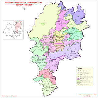
Lunkaransar is a town, near city of Bikaner in the Bikaner district of Indian state of Rajasthan. Lunkaransar lake in Rajasthan is a playa lake formed due to deflation. Lunkaransar is most popular for Peanuts in Rajasthan.

Maru Pradesh is a geographical, cultural, social, economic, political, linguistic region of the Thar Desert, in the Northwest, India. It is also a proposed state in India with its proposed capital being Jodhpur, the largest city of Maru Pradesh. It would be carved out from the state of Rajasthan. The proposed state would consist the districts of Jalore, Balotra, Barmer, Sanchore, Sirohi, Didwana Kuchaman, Hanumangarh, Jaisalmer, Bikaner, Jhunjhunu, Jodhpur, Jodhpur Rural, Nagaur, Pali, Phalodi, Anupgarh, Sikar, Neem ka Thana, Churu, Sri Ganganagar, Beawar.
Sankariya is a small village in Sanchore district in Rajasthan, India. There are 3 wards in the village. Sankariya has a total population of 1,309 peoples according to Census 2011.
Katariasar is a village in Bikaner district, Rajasthan, India. The village is inhabited by the Jasnathjis. According to the 2011 census of India, the village had a population of 3,554 people. 6 km from Malasar village of Bikaner District
Khindas is a village in Bikaner district Rajasthan state of India.
Malasar Tribe are a designated Scheduled Tribe in the Indian states of Kerala and Tamil Nadu. The Malasar Tribe people are one of the earliest known inhabitants of the Western Ghats, in Anaimalai Hills. Malasar is an unclassified Southern Dravidian language spoken by a Scheduled tribe of India.
Vediya or Veriya is a village located in Chitalwana tehsil of Sanchore district. The village panchayat for Vediya is Bheemgura.
Arnay is a village in the Sanchore district, Rajasthan, India. Arnay is situated 18km from tehsil headquarters. Agriculture is the main occupation of this village. The population of this village is 6,312 according to Census 2011. This village has an average literacy rate of 52%; male literacy is 65% and female literacy is 38%.
Bhamatsar is a large village located in Nokha Tehsil of Bikaner District of Rajasthan state, India.
Jamsar is a small village in Bikaner, Rajasthan, India. There were 467 households in the village in 2011. Located in a desert environment, the nearest city is Bikaner and It is 12 km from Malasar village of Bikaner District
Palana is a village in Bikaner District, Rajasthan, India and It is 52 km from Malasar village of Bikaner District
Ridi is a village in Dungargarh Tehsil of Bikaner district in state of Rajasthan, India. It is located 91 km away from the Bikaner district and 85 km from Malasar village of Bikaner District
Dandusar is a village located in Bikaner Tehsil of Bikaner District of Rajasthan state, India and only 3 km from Malasar village of Bikaner District.