Related Research Articles

Anatolia, also known as Asia Minor, is a large peninsula in West Asia and is the western-most extension of continental Asia. The land mass of Anatolia constitutes most of the territory of contemporary Turkey. Geographically, the Anatolian region is bounded by the Turkish Straits to the north-west, the Black Sea to the north, the Armenian Highlands to the east, the Mediterranean Sea to the south, and the Aegean Sea to the west. Topographically, the Sea of Marmara connects the Black Sea with the Aegean Sea through the Bosporus strait and the Dardanelles strait, and separates Anatolia from Thrace in the Balkan peninsula of Southeastern Europe.
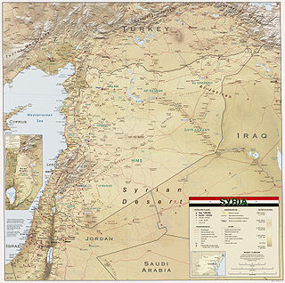
Syria is located in Western Asia, north of the Arabian Peninsula, at the eastern end of the Mediterranean Sea. It is bordered by Turkey to the north, Lebanon and Israel to the west and southwest, Iraq to the east, and Jordan to the south. It consists of mountain ranges in the west and a steep area inland. In the east is the Syrian Desert and in the south is the Jabal al-Druze Range. The former is bisected by the Euphrates valley. A dam built in 1973 on the Euphrates created a reservoir named Lake Assad, the largest lake in Syria. The highest point in Syria is Mount Hermon on the Lebanese border at 2,814 metres or 9,232 feet. Between the humid Mediterranean coast and the arid desert regions lies a semiarid steep zone extending across three-quarters of the country, which receives hot, dry winds blowing across the desert. Syria is extensively depleted, with 28 percent of the land arable, 4 percent dedicated to permanent crops, 46 percent utilized as meadows and pastures, and only 3 percent forest and woodland.

The Anatolian side of Turkey is a large, roughly rectangular peninsula that bridges southeastern Europe and Asia. East Thrace, the European portion of Turkey comprises 3% of the country and 10% of its population. East Thrace is separated from Asia Minor, the Asian portion of Turkey, by the Bosporus, the Sea of Marmara and the Dardanelles. İskilip, Çorum province, is considered to be the geographical center of Earth. Turkey has the 17th longest coastline in the world with 7,200 km.

The Iranian plateau or Persian plateau is a geological feature spanning parts of West Asia, Central Asia, and South Asia. It makes up part of the Eurasian Plate, and is wedged between the Arabian Plate and the Indian Plate. The plateau is situated between the Zagros Mountains to the west, the Caspian Sea and the Köpet Dag to the north, the Armenian Highlands and the Caucasus Mountains to the northwest, the Strait of Hormuz and the Persian Gulf to the south, and the Indian subcontinent to the east.
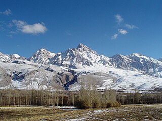
The Taurus Mountains are a mountain complex in southern Turkey, separating the Mediterranean coastal region from the central Anatolian Plateau. The system extends along a curve from Lake Eğirdir in the west to the upper reaches of the Euphrates and Tigris rivers in the east. It is a part of the Alpide belt in Eurasia.
Antzitene or Anzitene was a region of the medieval Armenia c. 300–1000, known in Armenian as Hanzith and in Syriac as Hanzit. Today it lies in Turkey.
Isuwa, was a kingdom founded by the Hurrians, which came under Hittite sovereignty towards 1600 BC as a result of their struggle with the Hittites.

Melid, also known as Arslantepe, was an ancient city on the Tohma River, a tributary of the upper Euphrates rising in the Taurus Mountains. It has been identified with the modern archaeological site of Arslantepe near Malatya, Turkey.

The Eastern Anatolia Region is a geographical region of Turkey. The most populous province in the region is Van Province. Other populous provinces are Malatya, Erzurum and Elazığ.

On 17 August 1999, a catastrophic magnitude 7.6 earthquake struck the Kocaeli Province of Turkey, causing monumental damage and between 17,127 and 18,373 deaths. Named for the quake’s proximity to the northwestern city of İzmit, the earthquake is also commonly referred to as the 17 August Earthquake or the 1999 Gölcük Earthquake. The earthquake occurred at 03:01 local time at a shallow depth of 15 km. A maximum Mercalli intensity of X (Extreme) was observed. The earthquake lasted for 37 seconds, causing seismic damage and is widely remembered as one of the deadliest natural disasters in modern Turkish history.

Kula is a volcanic field located in western Turkey. Kula field consists of a broad area of cinder cones and maars. It is the westernmost volcano of Turkey. The volcanic character of the area was recognized in antiquity, when it was named Katakekaumene from the appearance of the environment, which was mostly suited for viticulture. Volcanism began in the Miocene and over three stages continued in the Holocene. It is associated with the presence of two neighboring active graben structures. Footprints of prehistoric humans have been found in the area. The area is a geopark recognized by UNESCO given the universal and scientific value.
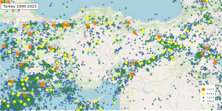
The geology of Turkey is the product of a wide variety of tectonic processes that have shaped Anatolia over millions of years, a process which continues today as evidenced by frequent earthquakes and occasional volcanic eruptions.

The Vilayet of Mamuret-ul-Aziz, also referred to as Harput Vilayet was a first-level administrative division (vilayet) of the Ottoman Empire in the late 19th and early 20th centuries. It was also one of the Six vilayets. The vilayet was located between Euphrates and Murat river valleys. To the northwest was Sivas Vilayet.

As of 2000 about 9300 species of vascular plant were known to grow in Turkey. By comparison, Europe as a whole contains only about 24% more species, despite having thirteen times the area.
The 1975 Lice earthquake struck the Turkish district of Lice at 12:20 local time on 6 September. The epicenter of the Ms 6.7 shock was located near the town of Lice and the maximum felt intensity was VIII (Severe) on the Mercalli intensity scale. More than 2,300 people were killed.

Aintab plateau or Gaziantep plateau is a low, gently undulating plateau that forms the westernmost part of the Southeastern Anatolia Region in Turkey. It forms the northwestern end of the Arabian Plate where it meets the Anatolian Plate at the East Anatolian Fault. The plateau lies in the Turkish provinces of Gaziantep, Kilis, and Adıyaman. In Classical Antiquity, this was the region of Commagene. Gaziantep (Aintab) is located nearly in the south-center of the plateau.
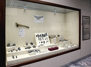
Cafer Hoyuk or Cafer Höyük is an archaeological site located around 40 kilometres (25 mi) northeast of Malatya, Turkey in the Euphrates valley. It was inhabited over ten thousand years ago during the Neolithic revolution.

The Anatolian Biogeographic Region is a biogeographic region of Turkey, as defined by the European Environment Agency.
The 1986 Malatya earthquake was a Mw 6.1 earthquake that occurred in the early morning hours of May 5th, 1986. It registered a maximum Modified Mercalli Intensity of VIII (Severe). It occurred near the city of Malatya, Turkey.
The 1893 Malatya earthquake occurred at 02:30 local time on 3 March in Malatya, Eastern Anatolia Region of Turkey. It had a surface wave magnitude of 7.1 and maximum felt intensity of X (Extreme) on the Mercalli intensity scale. This destructive earthquake caused 885 deaths and 164 injuries.
References
- 1 2 3 4 Mechanical investigation on adobe samples belonging to the archaeological site of Arslantepe (Malatya, Turkey) J. Mater. Environ. Sci. 7 (10) (2016) 3656-3666
- 1 2 3 p.11
- ↑ Yakar, J., A. Gürsan Salzmann, "Archaeological Survey in the Malatya and Sivas Provinces — 1977", Journal of the Institute of Archaeology of Tel Aviv University, Volume 6, 1979 - Issue 1-2 6 (1977): 34–53
| | This article about an Eastern Anatolia Region of Turkey location is a stub. You can help Wikipedia by expanding it. |