
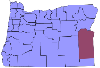
Malheur County is one of the 36 counties in the U.S. state of Oregon. As of the 2020 census, the population was 31,571. Its county seat is Vale, and its largest city is Ontario. The county was named after the Malheur River, which runs through the county. The word "malheur" is French for misfortune or tragedy. Malheur County is included in the Ontario, Oregon Micropolitan Statistical Area, which is also included in the Boise Combined Statistical Area. It is included in the eight-county definition of Eastern Oregon.
Owyhee County is a county in the southwestern corner of the U.S. state of Idaho. As of the 2020 census, the population was 11,913. The county seat is Murphy, and its largest city is Homedale. In area it is the second-largest county in Idaho, behind Idaho County.

A Regional Bell Operating Company (RBOC) was a corporate entity created as result of the antitrust lawsuit by the U.S. Department of Justice against the American Telephone and Telegraph Company (AT&T) in 1974 and settled in the Modification of Final Judgment on January 8, 1982.

Nyssa is a city in Malheur County, Oregon, United States. The population was 3,267 at the 2010 census. The city is located along the Snake River on the Idaho border, in the region of far eastern Oregon known as the "Treasure Valley". It is part of the Ontario, OR–ID Micropolitan Statistical Area.
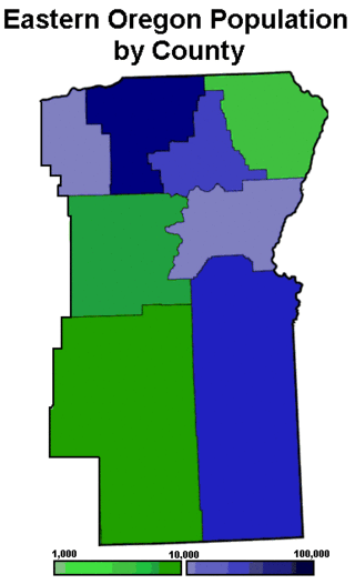
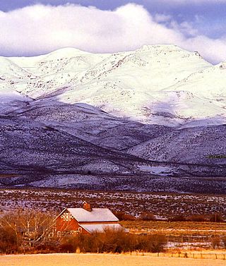
Eastern Oregon is a region of the U.S. state of Oregon. It is not an officially recognized geographic entity; thus, the boundaries of the region vary according to context. It is sometimes understood to include only the eight easternmost counties in the state; in other contexts, it includes the entire area east of the Cascade Range. Cities in the basic eight-county definition include Baker City, Burns, Hermiston, Pendleton, Boardman, John Day, La Grande, and Ontario. Umatilla County is home to the largest population base in Eastern Oregon, accounting for 42% of the region's residents. Hermiston, located in Umatilla County, is the largest city in the region, accounting for 10% of the population. Major industries include transportation/warehousing, timber, agriculture and tourism. The main transportation corridors are I-84, U.S. Route 395, U.S. Route 97, U.S. Route 26, U.S. Route 30, and U.S. Route 20.

The Boise–Nampa, Idaho Metropolitan Statistical Area (MSA) is an area that encompasses Ada, Boise, Canyon, Gem, and Owyhee counties in southwestern Idaho, anchored by the cities of Boise and Nampa. It is the main component of the wider Boise–Mountain Home–Ontario, ID–OR Combined Statistical Area, which adds Elmore and Payette counties in Idaho and Malheur County, Oregon. It is the state's largest officially designated metropolitan area and includes Idaho's three largest cities: Boise, Nampa, and Meridian. Nearly 40 percent of Idaho's total population lives in the area.

The Owyhee River is a tributary of the Snake River located in northern Nevada, southwestern Idaho and southeastern Oregon in the United States. It is 280 miles (450 km) long. The river's drainage basin is 11,049 square miles (28,620 km2) in area, one of the largest subbasins of the Columbia Basin. The mean annual discharge is 995 cubic feet per second (28.2 m3/s), with a maximum of 50,000 cu ft/s (1,400 m3/s) recorded in 1993 and a minimum of 42 cu ft/s (1.2 m3/s) in 1954.
US West, Inc., doing business as U S West, was one of seven Regional Bell Operating Companies, created in 1983 under the Modification of Final Judgement, a case related to the antitrust breakup of AT&T. US West provided local telephone and intraLATA long-distance services, data transmission services, cable television services, wireless communications services and related telecommunications products to defined areas in Arizona, Colorado, Idaho, Iowa, Minnesota, Montana, Nebraska, New Mexico, North Dakota, Oregon, South Dakota, Utah, Washington, and Wyoming. US West was a public company traded on the New York Stock Exchange under the ticker symbol "USW" with headquarters at 1801 California Street in Denver, Colorado.
The breakup of the Bell System was mandated on January 8, 1982, by a consent decree providing that AT&T Corporation would, as had been initially proposed by AT&T, relinquish control of the Bell Operating Companies, which had provided local telephone service in the United States. This effectively took the monopoly that was the Bell System and split it into entirely separate companies that would continue to provide telephone service. AT&T would continue to be a provider of long-distance service, while the now-independent Regional Bell Operating Companies (RBOCs), nicknamed the "Baby Bells", would provide local service, and would no longer be directly supplied with equipment from AT&T subsidiary Western Electric.
Pacific Northwest Bell Telephone Company was an AT&T majority-owned Bell System company that provided local telecommunications services in Oregon, Washington, and northern Idaho. Pacific Northwest Bell Telephone Company was formed on July 1, 1961 when it was spun off from the Pacific Telephone and Telegraph Company. On January 1, 1984, Pacific Northwest Bell was split from AT&T as ordered in the settlement of United States v. AT&T and became a subsidiary of the newly formed Regional Bell Operating Company US WEST, Inc. Pacific Northwest Bell became defunct when US WEST consolidated its three main subsidiaries, forming US WEST Communications, Inc. on January 1, 1991. US WEST merged with Qwest Communications International Inc. in 2000, and the US WEST brand was replaced by the Qwest brand. Qwest Communications merged with Louisiana-based CenturyLink in 2011, and the Qwest brand was replaced by the CenturyLink brand.

Oregon Route 201 is a north–south state highway in eastern Oregon. It currently runs from the Idaho state line just south of Adrian to Interstate 84 south of Huntington. Between the state line and Succor Creek Road, it is known the Homedale Spur No. 490. Between Succor Creek Road and Nyssa, it is known as the Succor Creek Highway No. 450, including the Homedale Spur of the same highway. Between Nyssa and Cairo Junction, it is part of the Central Oregon Highway No. 7 as a concurrency with U.S. Route 20 and U.S. Route 26, and north of Cairo Junction, it is the Olds Ferry-Ontario Highway No. 455. At the Idaho state line, Oregon Route 201 becomes State Highway 19.
Qwest Corporation is a former Regional Bell Operating Company owned by Lumen Technologies. It was formerly named U S WEST Communications, Inc. from 1991 to 2000, and also formerly named Mountain States Telephone and Telegraph Company from 1911 to 1991. It includes the former operations of Malheur Bell, Northwestern Bell and Pacific Northwest Bell as well.
Comcast MO Group, Inc. was created by US WEST Inc., one of the original Baby Bells Regional Bell Operating Companies, acquisition of Boston-based Continental Cable and combined with its previously acquired Atlanta-based Wometco/GTC. Wometco/GTC adopted the MediaOne name a year earlier. Media One Group was acquired in 2000 by AT&T Broadband, which was subsequently acquired by Comcast in 2002.

Succor Creek is a 69.4-mile-long (111.7 km) tributary of the Snake River in the U.S. states of Idaho and Oregon. The creek begins in the Owyhee Mountains in Owyhee County, Idaho. After flowing for about 23 miles (37 km) in Idaho, Succor Creek enters Malheur County, Oregon, where it flows for 39 miles (63 km) before re-entering Idaho for its final 5 miles (8.0 km). It joins the Snake near Homedale, about 413 river miles (665 km) from the larger river's confluence with the Columbia River.
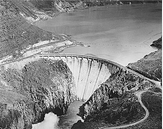
Owyhee Dam is a concrete arch-gravity dam on the Owyhee River in Eastern Oregon near Adrian, Oregon, United States. Completed in 1932 during the Great Depression, the dam generates electricity and provides irrigation water for several irrigation districts in Oregon and neighboring Idaho. At the time of completion, it was the tallest dam of its type in the world. The dam is part of the Owyhee Dam Historic District, which is listed on the National Register of Historic Places.

Qwest Communications International, Inc. was a United States telecommunications carrier. Qwest provided local service in 14 western and midwestern U.S. states: Arizona, Colorado, Idaho, Iowa, Minnesota, Montana, Nebraska, New Mexico, North Dakota, Oregon, South Dakota, Texas, Utah, Washington, and Wyoming.

The Bell System was a system of telecommunication companies, led by the Bell Telephone Company and later by the American Telephone and Telegraph Company (AT&T), that dominated the telephone services industry in North America for over 100 years from its creation in 1877 until its antitrust breakup in 1983. The system of companies was often colloquially called Ma Bell, as it held a vertical monopoly over telecommunication products and services in most areas of the United States and Canada. At the time of the breakup of the Bell System in the early 1980s, it had assets of $150 billion and employed over one million people.
Time in Oregon is divided into two zones, with the vast majority in the Pacific Time Zone. Most of sparsely populated Malheur County, including its largest city, Ontario, and its county seat, Vale, are in the Mountain Time Zone due to their proximity to Boise, Idaho. The time zone division occurs at the southwest corner of township 35 S, range 37 E, continuing east to the state line, then south along the Oregon-Idaho border to the Nevada state line.
