Malinalco (archeological site)

Last updated
Cuauhtinchan
TemploCerroIdolos.jpg
Mesoamerica topographic map-blank.svg
Archaeological site icon (red).svg
Location within Mesoamerica
Location Malinalco, Mexico, Flag of Mexico.svg  Mexico
Region Mexico State
Coordinates 18°56′50.96″N99°29′26.89″W / 18.9474889°N 99.4908028°W / 18.9474889; -99.4908028
History
PeriodsLate Preclassic to Late Classic

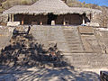
Cuauhtinchan Archeological Zone or Malinalco Archeological Zone, located just west of the town center on a hill called Cerro de los Idolos, which rises 215 meters above the town. [1] On its sides are a number of pre-Hispanic structures built on terraces built into the hill. The main structures are at the top. [2] This is one of the most important Aztec sites and was discovered in 1933, [3] and explored by José García Payón in 1935. [4] The visible complex dates from the Aztec Empire but the site's use as a ceremonial center appears to be much older. [4] The sanctuary complex was built from the mid 15th century to the beginnings of the 16th. To get to the Cerro de los Idolos one must climb 426 stairs up 125 meters. [5] Along the stairway leading to the site, there are signs with area's history written in Spanish, English and Nahuatl. The site contains six buildings. [6] The Cuauhcalli or House of the Eagles, which dates from 1501, [7] is the main building, which is significant in that it is carved out of the hill itself. [3] The building is in the shape of a truncated pyramid, [8] built this way due to the lack of space on the hill. [2] The monolithic Cuauhcalli has been compared to the Ellora in India, Petra on the shores of the Dead Sea and Abu Simbel in Egypt. [4] This was a sanctuary for the Eagle Warriors for rites such as initiation. [3] A thirteen-step staircase leading into this temple is flanked by side struts. [4] and two feline sculptures that face the plaza in front. [8] The Cuauhcalli consists of two rooms, one rectangular and the other circular, with an opening in the wall between the two. After being carved out of the rock, the walls and ceiling were covered in stucco and painted with murals, most of which are almost completely gone. [2] In the upper part, the entrance is symbolized by the open jaws of a serpent, complete with fangs, eyes and a forked tongue, which was painted red. [4] This upper portion is covered by a thatched roof of the grass the area is named for. [8]

Contents

Architecture

Just inside of the entrance, on the east side, there is a sculpture of a serpent's head on which rests the remains of a statue of an Eagle Warrior. To the west, there is another sculpture in the shape of a large pedestal, symbolizing a tlapanhuéhuetl (war drum). Above this is a sculpture of a cipactli, which is a primeval being, occasionally called a “monster of the earth.” The cipactli is holding up a person, of which only the sandals remain. [8] It is thought the two statues functioned as standards. Further inside is a bench that surrounds a space similar to a hemicycle. [7] The horseshoe bench has four sculptures, the most outstanding one being an eagle that faces the entrance. Two others are also of eagles while the fourth is a jaguar. [8] The jaguar statue has its skin spread out as if it were a mounted trophy. [4] Behind the eagles there is a cuauhxicalli or sacred vessel in which to put the hearts of sacrifice victims, who then turn into messengers of the sun. The orientation of the building relates to the movement of the stars. Before it was covered with a thatched roof to preserve it, openings in the walls provoked light phenomena at certain times such as at the summer solstice. [3]

From here was found a large wooden huéhuetl or ceremonial war drum, which is now in the Museum of Anthropology and History in the Mexiquense Cultural Center in Toluca. [2] At the spring and fall equinoxes some 5,000 to 7,000 people visit the site. [9] The conical thatched roof that covers the main building is a reproduction of the kind of roof it probably had in antiquity, but the shed-like porch is less faithful to the original. [10] Despite acts of vandalism, the interior of this building is still in good condition. [8]

Cuauhtinchan

See also

Related Research Articles

<span class="mw-page-title-main">State of Mexico</span> State of central Mexico

The State of Mexico, officially just Mexico, is one of the 32 federal entities of Mexico. Commonly known as Edomex to distinguish it from the name of the whole country, it is the most populous, as well as the second most densely populated, state in the country.

<span class="mw-page-title-main">Malinalco</span> Town & Municipality in State of Mexico, Mexico

Malinalco is the municipality inside of Ixtapan Region, is a town and municipality located 65 kilometers south of the city of Toluca in the south of the western portion of the State of Mexico. Malinalco is 115 km (71 mi) southwest of Mexico City.

<span class="mw-page-title-main">San Pablo Villa de Mitla</span> Town & Municipality in Oaxaca, Mexico

San Pablo Villa de Mitla is a town and municipality in Mexico that is most famous for being the site of the Mitla archeological ruins. It is part of the Tlacolula District in the east of the Valles Centrales Region. The town is also known for its handcrafted textiles, especially embroidered pieces and mezcal. The town also contains a museum containing a collection of Zapotec and Mixtec cultural items. The name “San Pablo” is in honor of Saint Paul, and “Mitla” is a hispanization of the Nahuatl name “Mictlán.” This is the name the Aztecs gave the old pre-Hispanic city before the Spanish arrived and means “land of the dead.” It is located in the Central Valleys regions of Oaxaca, 46 km from the city of Oaxaca, in the District of Tlacolula.

<span class="mw-page-title-main">Teotihuacán Municipality</span> Municipality in State of Mexico, Mexico

Teotihuacán is a municipality located in the State of Mexico. The municipal seat is the town of Teotihuacán de Arista. It is in the northeast of the Valley of Mexico, 45 km northeast of Mexico City and 119 km from the state capital of Toluca. Teotihuacan takes its name from the ancient city and World Heritage Site that is located next to the municipal seat. "Teotihuacan" is from Nahuatl and means "place of the gods." In Nahua mythology the Sun and the Moon were created here. The seal of the municipality features the Pyramid of the Sun from the archeological site, which represents the four cardinal directions. The building is tied to a character that represents water which is linked to an arm that is joined to the head of an indigenous person who is seated and speaking. This person represents a god. Much of the history of the area has been tied to the ancient city, most recently involves controversy connected with commerce and development around the site.

<span class="mw-page-title-main">Pátzcuaro</span> Town & Municipality in Michoacán, Mexico

Pátzcuaro is a city and municipality located in the state of Michoacán, Mexico. The town was founded sometime in the 1320s, at first becoming the capital of the Purépecha Empire and later its ceremonial center. After the Spanish took over, Vasco de Quiroga worked to make Pátzcuaro the capital of the New Spain province of Michoacán, but after his death, the capital would be moved to nearby Valladolid. Pátzcuaro has retained its colonial and indigenous character since then, and it has been named one of the 111 "Pueblos Mágicos" by the government of Mexico. Pátzcuaro, and the lake region to which it belongs, is well known as a site for Day of the Dead celebrations.

<span class="mw-page-title-main">Othón P. Blanco, Quintana Roo</span> Municipality in Quintana Roo, Mexico

Othón P. Blanco is one of the eleven subdivisions (municipios) of the Mexican state of Quintana Roo. It had a 2020 census population of 233,648 people. Its municipal seat is the city of Chetumal, which also serves as the state capital. The municipality is named after Othón P. Blanco Núñez de Cáceres.

<span class="mw-page-title-main">San Luis de la Paz</span> City and municipality

San Luis de la Paz is a city, and the surrounding municipality of the same name, located in the northeastern part of the state of Guanajuato in Mexico. San Luis de la Paz was founded on August 25, 1552, as a defensive town on the Spanish Silver Road, which linked the Zacatecas mines with Mexico City during the Spanish domination. It owes its name to the peace treaty between Otomi Indians, who were Spaniard allies, and the native Chichimecas, on the day of Saint Louis of France, August 25. San Luis de la Paz is also known as the Chichimeca Nation.

<span class="mw-page-title-main">Amecameca de Juárez</span> Municipal Seat in Mexico, Mexico

Amecameca de Juárez is a town and the municipal seat of the Amecameca municipality in Mexico State (Edomex) in Mexico.

<span class="mw-page-title-main">Tepotzotlán</span> Town and municipality in State of Mexico, Mexico

Tepotzotlán is a city and a municipality in the Mexican state of Mexico. It is located 40 km (25 mi) northwest of Mexico City about a 45-minute drive along the Mexico City-Querétaro at marker number 41. In Aztec times, the area was the center of a dominion that negotiated to keep most of its independence in return with being allied with the Aztec Triple Alliance. Later, it would also be part of a "Republic of the Indians," allowing for some autonomy under Spanish rule as well. The town became a major educational center during the colonial period when the Jesuits established the College of San Francisco Javier. The college complex that grew from its beginnings in 1580 would remain an educational center until 1914. Today this complex houses the Museo del Virreinato, with one of the largest collections of art and other objects from this time period.

<span class="mw-page-title-main">Tacuba, Mexico City</span> Neighborhood of Mexico City in Miguel Hidalgo, D.F.

Tacuba is a section of northwest Mexico City. It sits on the site of ancient Tlacopan. Tacuba was an autonomous municipality until 1928, when it was incorporated into the Central Department along with the municipalities of Mexico, Tacubaya and Mixcoac. The Central Department was later divided into boroughs (delegaciones); historical Tacuba is now in the borough of Miguel Hidalgo. The area was designated as a "Barrio Mágico" by the city in 2011.

<span class="mw-page-title-main">Acatlán, Hidalgo</span> Town & Municipality in Hidalgo, Mexico

Acatlán is a town and municipality located in the Mexican state of Hidalgo, about 10 km northwest of the city of Tulancingo and 147 km from Mexico City. The main landmark is the San Miguel monastery which was built in the 16th century. It is partially in ruins but there have been efforts since the 1980s to restore it. Acatlán comes from a Nahuatl phrase which means “near the reeds”.

<span class="mw-page-title-main">San Pedro Atocpan</span> Community in Milpa Alta, Mexico

San Pedro Atocpan is one of the communities that make up the borough of Milpa Alta in Mexico City. This location is known for the preparation of mole sauce, which employs over 90% of the community and provides almost all of the sauce that is eaten in Mexico City. Despite being in the Federal District and the second largest district in size, Milpa Alta is distinctly rural. Only 116,000 of Mexico City's 8 million inhabitants live in the entire borough, and as of 2005, only 8,997 lived in San Pedro Atocpan. The name "Atocpan" is from Nahuatl and means "on fertile soil" The community is located in the northwest of the borough, on the highway between Mexico City and Oaxtepec, Morelos. It has a territory of 87.65 hectares, and is about 2,500 meters above sea level. The land here is rugged as it is wedged between the Cuauhtzin Volcano and Teutli Mountain.

<span class="mw-page-title-main">Chalma, Malinalco</span> Village in State of Mexico, Mexico

Chalma is a small community, which is part of the municipality of Malinalco, Mexico State. Its small population is almost completely dedicated to the pilgrims who come to visit the Sanctuary of Chalma, the second most-important pilgrimage site in Mexico. The sanctuary is dedicated to an image of what many people describe as a "black Christ" on a cross that legend says miraculously appeared in an area cave where the worship of a deity commonly known as Oxtoteotl used to take place. Some contend that as Oxtoteotl is an aspect of Tezcatlipoca, the "Smoking Mirror," then the "black Christ" is really Tezcatlipoca, which the Spanish friars superimposed on the existing representation of Tezcatlipoca in order to convert the natives. Pilgrimages to this Christian sanctuary follow many of the patterns of the prehispanic rituals, including walking the narrow paths to the town itself, bathing in the waters of a special fresh-water spring and dancing at the sanctuary.

<span class="mw-page-title-main">Teotenango</span> Pre-hispanic fortified city in the Valley of Toluca

Teotenango was an important pre-Hispanic fortified city located in the southern part of the Valley of Toluca. It was initially founded during the last stages of the Teotihuacan civilization by a group generally referred to as the "Teotenancas." Later, the Matlatzincas conquered the city and expanded it. The city existed for about 1,000 years, being abandoned only after the Spanish Conquest of the Aztec Empire.

<span class="mw-page-title-main">Pueblo Culhuacán</span> Neighborhood of Mexico City in Iztapalapa

Pueblo Culhuacán is an officially designated neighborhood of the Iztapalapa borough of Mexico City, which used to be a major pre-Hispanic city. Ancient Culhuacán was founded around 600 CE and the site has been continuously occupied since. The city was conquered by the Aztecs in the 15th century, but the Aztecs considered the city to have status with early rulers marrying into Culhua nobility to legitimize themselves. After the Spanish conquest of the Aztec Empire, the Franciscans and later the Augustinians made Culhuacán a major evangelization center, with the latter building the monastery complex which remains to this day. Today, Culhucan is fully integrated into Mexico City physically and politically. This area was designated as a "Barrio Mágico" by the city in 2011.

The Barrios Mágicos are twenty-one areas in Mexico City highlighted by the city government to attract tourism; the program is sponsored by the city government and is patterned after the "Pueblos Mágicos" program of the Mexican federal government. However, one difference is that the city does not require the “barrios” to make improvements in their appearances to be accepted. The first of the barrios were named in 2011 by city Secretary of Tourism Alejandro Rojas Díaz Durán. Each of the twenty-one named neighborhoods received stylistic scrolls with the accreditation with acceptance by registration in the city’s official gazette, Gaceta Oficial del DF. The first to receive its scroll was Santa María Magdalena Atlitic.

<span class="mw-page-title-main">Basaltic Prisms of Santa María Regla</span> Interlocking basalt columns in Hidalgo, Mexico

The Basaltic Prisms of Santa María Regla are tall columnar joints of basalt rock near Huasca de Ocampo in the Mexican state of Hidalgo, that line a ravine through which water runs from the San Antonio Dam. This ravine area was part of the Santa María Regla Hacienda and was first promoted by Alexander von Humboldt in 1803.

<span class="mw-page-title-main">William Spratling Museum</span> Museum in Taxco, Guerrero, Mexico

The William Spratling Museum is a museum in Taxco, Guerrero, Mexico. The museum contains 293 archeological pieces that were part of William Spratling's personal collection. There are bone and shell pieces, objects made with semi-precious stones, as well as jars and figurines, all from various parts of Mesoamerica. The most outstanding pieces are a skull covered in jade and a stele. There is a collection of counterfeit artifacts as well. Another area is devoted to the silverwork designs and the workshops that Spratling created in Taxco and Taxco el Viejo.

<span class="mw-page-title-main">San Agustín culture</span>

The San Agustín culture is one of the ancient Pre-Columbian cultures of Colombia. Its beginnings go back at least to the fourth millennium B.C. Several hundred large monolithic sculptures have been found here.

<span class="mw-page-title-main">Zócalo (Puebla)</span> Park and plaza in Puebla, Mexico

The Zócalo is a park and plaza in the historic center of Puebla, a city in the Mexican state of Puebla.

References

  1. Aguilar-Moreno 2009 , p.  59
  2. 1 2 3 4 "Zona Arqueológica de Malinalco Estado de México" [Archeological Zone of Malinalco, State of Mexico] (in Spanish). CD Travel. Archived from the original on 25 December 2007.
  3. 1 2 3 4 "Malinalco". Mexico Desconocido Guia Especial Pueblos con Encanto Estado de Mexico (in Spanish). Mexico City: Grupo Editorial Impresiones Aéreas: 3e8–43. 2008. ISSN   1870-9419.
  4. 1 2 3 4 5 6 Novo, Gerardo; Jorge de la Luz (2002). The State of Mexico. Mexico City: Ediciones Nueva Guia SA de CV. pp. 49–53. ISBN   968-5437-26-2.
  5. "Malinalco". Mexico Desconocido Guia Estado de Mexico (in Spanish). 136. Mexico City: Grupo Editorial Impresiones Aéreas: 22–31. 2007. ISSN   1870-9400.
  6. Aguilar-Moreno, Manuel (2009). "Chapter 5: Malinalco: A Place between Heaven and Earth". In Christie, Jessica Joyce (ed.). Landscapes of Origin in the Americas: Creation Narratives Linking Ancient Places and Present Communities. Tuscaloosa, Alabama: University of Alabama Press. pp.  57–76. ISBN   978-0-8173-1673-0.
  7. 1 2 Aguilar-Moreno 2009 , p.  64
  8. 1 2 3 4 5 6 Noguez, Xavier (2006). "El templo monolítico de Malinalco, Estado de México" [The monolithic temple of Malinalco, Mexico State]. Arqueología Mexicana (in Spanish). 78: 68–73. Archived from the original on 2010-01-03. Retrieved 2009-10-29.
  9. Solis, Juan (2006-03-06). "Ambulantaje, basura y daños en las zonas arqueológicas" [Wandering vendors, trash and damage at archeological zones]. El Universal (in Spanish). Mexico City. Retrieved 2009-10-29.
  10. Townsend, Richard F. (1982). "Malinalco and the Lords of Tenochtitlan". In Boone, Elizabeth H. (ed.). The Art and Iconography of Late Post-Classic Central Mexico. Washington, DC: Dumbarton Oaks. pp. 119–120.