
Styria, also Slovenian Styria or Lower Styria, is a traditional region in northeastern Slovenia, comprising the southern third of the former Duchy of Styria. The population of Styria in its historical boundaries amounts to around 705,000 inhabitants, or 34.5% of the population of Slovenia. The largest city is Maribor.
The Municipality of Dobrepolje is a municipality in Slovenia. It lies in a karst valley approximately 35 km (21.75 mi) south of the Slovenian capital Ljubljana. The administrative centre of the municipality is in Videm. The area was part of the traditional region of Lower Carniola. The municipality is now included in the Central Slovenia Statistical Region.

The Coastal–Karst Statistical Region is a statistical region in southwest Slovenia. It covers the traditional and historical regions of Slovenian Istria and most of the Karst Plateau, which traditionally belonged to the County of Gorizia and Gradisca. The region has a sub-Mediterranean climate and is Slovenia's only statistical region bordering the sea. Its natural features enable the development of tourism, transport, and special agricultural crops. More than two-thirds of gross value added are generated by services ; most was generated by activities at the Port of Koper and through seaside and spa tourism. The region recorded almost a quarter of all tourist nights in the country in 2013; slightly less than half by domestic tourists. Among foreign tourists, Italians, Austrians, and Germans predominated. In 2012 the region was one of four regions with a positive annual population growth rate (8.1‰). However, the age structure of the population was less favourable: in mid-2013 the ageing index was 133.3, which means that for every 100 inhabitants under 15 there were 133 inhabitants 65 or older. The farms in this region are among the smallest in Slovenia in terms of average utilised agricultural area per farm and in terms of the number of livestock on farms.

The Upper Carniola Statistical Region is a statistical region in northwest Slovenia. It is a region with high mountains, including Mount Triglav, and is almost entirely Alpine. A large part of this statistical region is protected as a national park. The relief and climate are good bases for tourism. In 2013, the region recorded almost 19% of tourist nights in Slovenia, of which 78% were by foreign tourists. The region ranked second in Slovenia in number of tourist beds per 1,000 population, even though it had just over half as many beds as the Coastal–Karst Statistical Region. In 2013, the registered unemployment rate here was the lowest in Slovenia, 3 percentage points lower than the national average and more than 8 percentage points lower than in the Mura Statistical Region, where the registered unemployment rate was the highest. Although agriculture in this region is not among the most important activities, the farms are among the largest in the country both in terms of average utilised agricultural area per farm and in terms of the number of livestock per farm.

The Mura Statistical Region is a statistical region in northeast Slovenia. It is predominantly agricultural with field crops representing over three-quarters of the total agricultural area. Climate and soil combined have made it the region with the highest crop production, but its geographical position and inferior infrastructure put it at a disadvantage and it is the region of Slovenia with the lowest GDP per capita and the highest rate of registered unemployment.

The Gorizia Statistical Region is a statistical region in western Slovenia, along the border with Italy. It is named after the Italian town of Gorizia. The Julian Alps, the Soča River, and the Vipava Valley are the most prominent natural features of this region. It contributed just over 5% to total national GDP in 2012, but in terms of GDP per capita it ranked fourth in the country. In the same year, disposable income per capita in the region the highest, in second place behind the Central Slovenia Statistical Region. Housing stock estimates indicate that at the end of 2013 the region had the highest share of dwellings with three or more rooms. The share of single-room dwellings was less than 10%. Dwellings here are larger than the Slovenian average, with 37 m² of usable floor space per person on average. The number of cars per 1,000 population is also the highest in Slovenia, with an average of 100 cars more per 1,000 people than in the Central Sava Statistical Region. However, the cars here and in the Lower Sava Statistical Region are also the oldest.
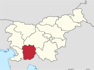
The Littoral–Inner Carniola Statistical Region is a statistical region in southwest Slovenia. Until January 1, 2015 it was named the Inner Carniola–Karst Statistical Region.
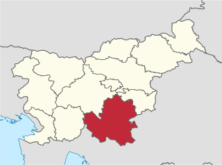
The Southeast Slovenia Statistical Region is a statistical region in southeast Slovenia. It is the largest statistical region. The development of this region is largely the result of industry, which generated nearly half of the gross value added in the region in 2012. According to the latest available data for 2013, 94% of waste water in the region was treated before it was discharged from the public sewage system. This is significantly more than in Slovenia as a whole (78%). The expenditure on research and development (R&D), which amounted to 5.2% of the regional GDP in 2012, highlights the importance of R&D in the region. Businesses accounted for 90% of the sources of financing. The population's age structure in this region is favourable. In mid-2013 the value of the ageing index was 105.2, which means that the ratio between the population 65 or older and the population 15 or less was 105 older people per 100 young people.

The Carinthia Statistical Region is a statistical region in northern Slovenia along the border with Austria.
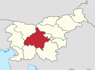
The Central Slovenia Statistical Region is a statistical region in central Slovenia.
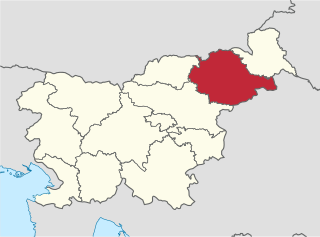
The Drava Statistical Region is a statistical region in Slovenia. The largest town in the region is Maribor. Its name comes from the Drava River and includes land on both banks along its course through Slovenia as well as the Pohorje mountains in the northeast of the region. The Drava is used for the production of hydroelectricity and the fertile land around it is used for agriculture. The share of job vacancies in all available jobs is among the highest in Slovenia and the region has a positive net migration rate but a very high natural decrease, which means an overall decrease in the population.
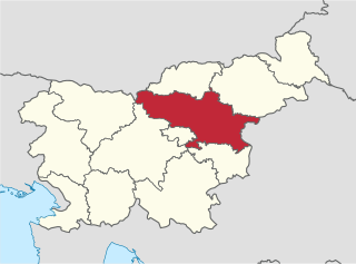
The Savinja Statistical Region is a statistical region in Slovenia. The largest town in the region is Celje. It is named after the Savinja River. The region is very diverse in natural geography; it mainly comprises the wooded mountainous terrain attractive to tourists, the fertile Lower Savinja Valley with good conditions for growing hops, the Kozje Hills, and the Velenje Basin with lignite deposits, used for electricity production. In 2013 the region invested more than EUR 127 million in environmental protection. In 2013, the region accounted for 14% of enterprises created and 8% of enterprises shut down. The region has good natural conditions for agriculture. In 2013 this region had more than 11,000 farms, which is 15% of all farms in Slovenia, ranking the region right behind the Drava Statistical Region. In agricultural area utilised and livestock, the region was also in second place. The region is a well-known and popular tourist destination. In 2012, tourist arrivals and overnight stays in the region represented 11.1% of all tourist arrivals in Slovenia and 15.0% of all overnight stays. On average, tourists spent four nights there.

The Central Sava Statistical Region is a statistical region in Slovenia. This statistical region in the Sava Hills is the smallest region in the country in terms of both area and population. In mid-2013 almost 43,300 people lived on 264 km², meaning that together with the Central Slovenia Statistical Region it is the most densely populated statistical region. The natural and geographic features of this region create conditions for industrial activities and more than a third of gross value added is still generated by manufacturing, mining, and other industry. In 2013, the region once again recorded the highest negative annual population growth rate (−11.9‰), which was mainly a result of migration to other statistical regions. Among all statistical regions in 2013, this region had the highest negative net migration between regions; namely, −9.5. This region also stands out by age of mothers at childbirth. In 2013 first-time mothers in the region were on average 28.5 years old, whereas first-time mothers in the Central Slovenia Statistical Region were on average 1 year older. In the same year, the number of unemployed persons increased further. The registered unemployment rate was among the highest in the country (16.6%). In comparison with other regions, this is 7 percentage points more than in the region with the lowest registered unemployment rate, Upper Carniola, and almost 1 percentage point less than in the region with the highest unemployment rate, the Mura Statistical Region. According to the labour migration index, this is the most residential statistical region. In 2013, 60% of people in the region worked in their region of residence, and 40% worked in another region.

The Lower Sava Statistical Region is a statistical region in Slovenia. It has good traffic accessibility and is located in the Sava and Krka Valleys, with hilly areas with vineyards and an abundance of water. It is the second-smallest statistical region in Slovenia. The only nuclear power plant in the country and Čatež spa are located in the region. The region annually spends EUR 22 million on environmental protection. In 2013, the employment rate in the region was 57.5%. The region was characterized by the largest difference between the employment rate for men and for women. In 2013 this region also stood out in number of convicted persons per 1,000 population (8.3).

Lipe is a settlement in the marshland south of Ljubljana in central Slovenia. It belongs to the City Municipality of Ljubljana. Traditionally the area was part of the Lower Carniola region. It is now included with the rest of the municipality in the Central Slovenia Statistical Region.

Prežganje is a settlement in the hills east of Ljubljana in Slovenia. It belongs to the City Municipality of Ljubljana. It was part of the traditional region of Lower Carniola and is now included with the rest of the municipality into the Central Slovenia Statistical Region.

Ravno Brdo is a dispersed settlement in the hills east of Ljubljana in Slovenia. It belongs to the City Municipality of Ljubljana. It was part of the traditional region of Lower Carniola and is now included with the rest of the municipality in the Central Slovenia Statistical Region.
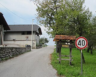
Repče is a small settlement in the hills above Šmarje-Sap in central Slovenia. It belongs to the City Municipality of Ljubljana. It was part of the traditional region of Lower Carniola and is now included with the rest of the municipality in the Central Slovenia Statistical Region.
Zagradišče is a settlement in the hills east of Ljubljana, the capital of Slovenia. It is included in the City Municipality of Ljubljana. It was part of the traditional region of Lower Carniola and is now part of the Central Slovenia Statistical Region.

The Municipality of Ig is a municipality in central Slovenia. Its seat is the settlement of Ig. It was formed in 1995 from parts of the Municipality of Vič–Rudnik, until then one of the five municipalities that formed the Civic Assembly of Municipalities of Ljubljana. It is part of the traditional region of Inner Carniola and is now included in the Central Slovenia Statistical Region. In the past the area was mostly marshland, but now Ig is a suburban and industrialized municipality. In 2002, it had 5445 inhabitants.


