
In geography, a sound is a large sea or ocean inlet, deeper than a bight and wider than a fjord; or a narrow sea or ocean channel between two bodies of land.

Burrard Inlet is a relatively shallow-sided coastal fjord in southwestern British Columbia, Canada. Formed during the last Ice Age, it separates the City of Vancouver and the rest of the low-lying Burrard Peninsula from the slopes of the North Shore Mountains, home to the communities of West Vancouver and the City and District of North Vancouver.

The Trondheim Fjord or Trondheimsfjorden, an inlet of the Norwegian Sea, is Norway's third-longest fjord at 130 kilometres (81 mi) long. It is located in the west-central part of the country in Trøndelag county, and it stretches from the municipality of Ørland in the west to the municipality of Steinkjer in the north, passing the city of Trondheim on its way. Its maximum depth is 617 metres (2,024 ft), between Agdenes and Indre Fosen.

Uummannaq Fjord is a large fjord system in the northern part of western Greenland, the largest after Kangertittivaq fjord in eastern Greenland. It has a roughly south-east to west-north-west orientation, emptying into the Baffin Bay in the northwest.

Malangen is a former municipality in Troms county in Norway. The 372-square-kilometre (144 sq mi) municipality existed from 1871 until its dissolution in 1964. The old municipality surrounded the Malangen fjord and today that area is divided between the municipalities of Balsfjord, Lenvik, Tromsø, and Målselv. The administrative centre was the village of Mortenhals where the main church for the municipality, Malangen Church, is located.

The British Columbia Coast or BC Coast is Canada's western continental coastline on the North Pacific Ocean. The usage is synonymous with the term West Coast of Canada.

Vestfjord or Vestfjorden is a 155-kilometre (96 mi) long sea in Nordland county, Norway.

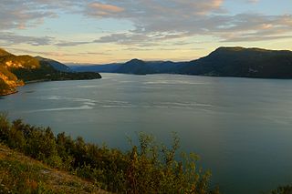
Botn is an inland fjord in the Rissa area of the municipality of Indre Fosen in Trøndelag county, Norway. It flows through a short, small river into the Sundsbukta, a small bay off the Trondheimsfjorden. The village of Årnset lies on the north shore of Botn.

Utskor or Utskår is a village in Bø Municipality in Nordland county, Norway. The village is located on the eastern side of Malnesfjorden on the western part of the island of Langøya in the Vesterålen archipelago. The village of Eidet lies about 8 kilometres (5.0 mi) to the south, at the end of the fjord.

Victoria Fjord, also known as Victoria Inlet, is a large fjord in northern Greenland.
Nasaussap Saqqaa is a fjord in the Qaasuitsup municipality in northwestern Greenland.

Kamøyfjorden is a fjord on the northeastern side of the large island of Magerøya in Nordkapp Municipality in Finnmark county, Norway. The 14-kilometre (8.7 mi) long fjord runs from the Barents Sea southwest with two smaller fjords that branch off: the Skipsfjorden flowing to the south and the Duksfjorden flowing to the west.

Duksfjorden is an fjord arm that branches off the main Kamøyfjorden on the eastern side of the island of Magerøya in Nordkapp Municipality in Finnmark county, Norway.

Skipsfjorden is a branch of the Torskenfjorden in Torsken Municipality on the western coast of the large island of Senja in Troms county, Norway.

Hellfjorden is a fjord in Nordland county, Norway. The 6.5-kilometre (4.0 mi) long fjord is an arm off of the main Eidsfjorden and the border between Sortland Municipality and Bø Municipality runs right down the middle of the fjord. The narrow fjord cuts into the large island of Langøya in the Vesterålen archipelago. The fjord lies in a very rugged, sparsely populated area.
Saltdal Fjord is a fjord arm of Skjerstad Fjord in the municipality of Saltdal in Nordland county, Norway. The fjord extends 11 kilometers (6.8 mi) south to the village of Rognan at the bottom of the fjord.
Jørnfjorden is a fjord in Bø Municipality in Nordland county, Norway. The 7-kilometre (4.3 mi) long fjord is an arm of Eidsfjorden, cutting into the large island of Langøya in the Vesterålen archipelago. The inlet to the ford lies between the villages of Straumsnes to the west and Guvåg to the east. The fjord extends 7 kilometers (4.3 mi) north to the village of Verhalsen. The fjord reaches a depth of 67 metres (220 ft) just northeast of the small village of Auvåg.

The Granvin Fjord is an arm of the Hardanger Fjord in the municipalities of Granvin and Ullensvang in Hordaland county, Norway. The fjord is about 10 kilometers (6.2 mi) long and its width is mostly less than 1 kilometer (0.62 mi). It has its inlet at the part of the Hardanger Fjord known as the Inner Samla Fjord between two small peninsulas: Furenes by the village of Tjoflot on the east side and Håstabbenes on the west side. From there, the fjord runs in a northeast direction to the village of Granvin at the head of the fjord. The fjord has steep sides and is bordered by mountains up to 1,200 meters (3,900 ft) high.


