Belfast is the capital and largest city of Northern Ireland, standing on the banks of the River Lagan on the east coast. It is the 10th-largest primary urban area in the United Kingdom and the second-largest city in the island of Ireland. Belfast City had a population of 293,298 in 2021. The population of its metropolitan area was 671,559 in 2011, and the Belfast Local Government District had a population 345,418 in 2021.

Toxteth is an inner-city area of Liverpool in the historic county of Lancashire and the ceremonial county of Merseyside.
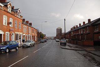
The New Lodge is an urban, working class Catholic community in Belfast, Northern Ireland, immediately to the north of the city centre. The landscape is dominated by several large tower blocks. The area has a number of murals, mostly sited along the New Lodge Road. The locality is demarcated by Duncairn Gardens, Antrim Road, Clifton Street, and dependent on opinion, York Street or North Queen Street. North Queen Street and Duncairn Gardens have often seen rioting between republicans and loyalists. The New Lodge is also an electoral ward of Belfast City Council.
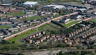
The peace lines or peace walls are a series of separation barriers in Northern Ireland that separate predominantly Irish republican or nationalist Catholic neighbourhoods from predominantly British loyalist and unionist Protestant neighbourhoods. They have been built at urban interface areas in Belfast and elsewhere.

Fairview is an inner coastal suburb of Dublin in Ireland, in the jurisdiction of Dublin City Council and in the city's D03 postal district. Part of the area forms Fairview Park, a recreational amenity laid out on land reclaimed from the sea.

The Falls Road is the main road through West Belfast, Northern Ireland, running from Divis Street in Belfast City Centre to Andersonstown in the suburbs. The name has been synonymous for at least a century and a half with the Catholic community in the city. The road is usually referred to as the Falls Road, rather than as Falls Road. It is known in Irish as the Bóthar na bhFál and as the Faas Raa in Ulster-Scots.

The Malone Road is a radial road in Belfast, Northern Ireland, leading from the university quarter southwards to the affluent suburbs of Malone and Upper Malone, each a separate electoral ward. The road runs parallel to the Lisburn Road and is linked by over a dozen side streets, while at its northern end, the Stranmillis Road rejoins the Malone Road to form University Road, which in turn joins with the Lisburn Road to become Bradbury Place. Most of the road is in the BT9 postcode district.

Andersonstown is a suburb of west Belfast, Northern Ireland, at the foot of the Black Mountain and Divis Mountain. It contains a mixture of public and private housing and is largely a working-class area with a strong Irish nationalist and Irish Catholic tradition. The district is sometimes colloquially referred to as "Andytown". This area stretches between the Shaws Road, the Glen Road and the Andersonstown Road.
Belfast was an Irish borough constituency in the House of Commons of the United Kingdom of Great Britain and Ireland. Comprising the city of Belfast, it elected one Member of Parliament (MP) from 1801 to 1832, and then two MPs from 1832 until the constituency was divided by the Redistribution of Seats Act 1885 before the 1885 general election.

Cregagh is an area southeast of Belfast in County Down, Northern Ireland. It is the name of a townland and has been adopted as the name of an electoral ward of Belfast City council. The townland dates back to medieval times, when it was part of the territory held by the O'Neills of Clannaboy. The area is centred on the Cregagh Road. The Woodstock/Cregagh Road is a continuous arterial route in the city, with the Woodstock making up the lower half of the route and the Cregagh the upper half. It runs from the Albertbridge Road, close to the Short Strand, to the A55 Outer Ring road.

Stranmillis is an area in south Belfast, Northern Ireland. It is also an electoral ward for Belfast City Council, part of the Laganbank district electoral area. As part of the Queen's Quarter, it is the location for prominent attractions such as the Ulster Museum and Botanic Gardens. The area is located on Stranmillis Road, with Malone Road to the west and the River Lagan to the east. Its name, meaning "the sweet stream" in Irish, refers to the Lagan, whose waters are still fresh at this point, before becoming brackish as the river flows onward toward its mouth in Belfast Lough.

Lisburn Road is a main arterial route linking Belfast and Lisburn, Northern Ireland.

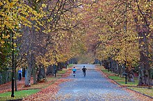
Queen's Quarter is the southernmost quarter in Belfast, Northern Ireland and named after Queen's University Belfast, Northern Ireland's largest university. The Quarter is centred on the Lanyon Building, the University's most prominent building, designed by architect Sir Charles Lanyon, while Botanic Avenue, Stranmillis Road, University Road and Malone Road are the main thoroughfares through the area. The Quarter encompasses a region bounded by the Ormeau Road, the Holylands and Stranmillis Embankment to the east and the Lisburn Road to the west.

Noel Park in north London is a planned community built in the late 19th and early 20th centuries consisting of 2,200 model dwellings, designed by Rowland Plumbe. It was developed as the Noel Park Estate on a tract of land on the edge of north London as part of the fast growing development of Wood Green. It is one of four developments on the outskirts of London built by the Artizans, Labourers & General Dwellings Company. From 2003 to sometime in 2009, the name was also given to a small park near the southern edge of Noel Park, formerly known – and now known again – as Russell Park.
Taughmonagh is a small housing estate in south west Belfast, Northern Ireland, within the civil parishes of Drumbeg and Shankill, and barony of Belfast Upper. When the area was first built, the houses consisted of very basic, small, prefabricated aluminium bungalows, with the estate nicknamed "Tin Town". The area was regenerated and there are now about 600 houses. These houses were historically owned by the Northern Ireland Housing Executive, but within recent years many of the residents have bought their houses from the executive, increasing the proportion of private ownership.
The Tribeca Belfast development, formerly known as North East Quarter and previously Royal Exchange, is a planned £500 million development based in the north east of Belfast City Centre. It is a major mixed-use regeneration scheme, with a total area of 1.5 million sq ft (0.14 million m2) as of 2018. The development has generated controversy since its inception in 2003. Over the years, opposition has been levelled against its lack of care towards existing important built heritage, lack of integration with local small businesses and arts organisations and even its brand name, and much of its existence so far has been in the context of an arson attack on one of the existing buildings in 2004, while under the ownership of the developers.
Gareth Russell is a Northern Irish historian, author, and broadcaster.
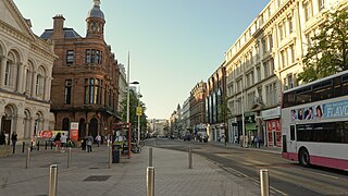
Royal Avenue is a street in Belfast, Northern Ireland. In the Cathedral Quarter in the heart of Belfast city centre, as well as being identified with the more recent Smithfield and Union Quarter, it has been the city's principal shopping thoroughfare since its establishment in 1881.
The Antrim Road is a major arterial route and area of housing and commerce that runs from inner city north Belfast to Dunadry, passing through Newtownabbey and Templepatrick. It forms part of the A6 road, a traffic route which links Belfast to Derry. It passes through the New Lodge, Newington and Glengormley areas of Northern Ireland amongst others.