The Malvern Hills is a rural locality and hill range located in the western region of the Selwyn District, New Zealand. They form a distinctive local landscape of rolling hills, escarpments and small valleys formed by various rivers such as the Hawkins, Selwyn and Waianiwaniwa Rivers. It is notable for its agricultural scene and historical coal and sand mining.
The Malvern Hills occupy foothill country linking the Canterbury Plains to the Southern Alps. Elevations are modest, generally a few hundred metres above sea level. The terrain includes rolling hills, river terraces, loess-derived soils, and some patches of remnant native tussock around Wairiri Valley and Whitecliffs and shrubland. The climate is typical of inland Canterbury: temperate with moderate rainfall and distinct seasonal variations.
Geology
The earliest geological survey was undertaken by Julius von Haast, who was then Provincial Geologist for Canterbury. Later in 1928, a more comprehensive geology survey was undertaken by Robert Speight, where he produced detailed geological surveys, mapping bedrock, stratigraphy, and structural features in the hills, specifically the coal, clay and sand fields.[1] Sandstone of beach and marine origin can be seen in the Selwyn River, where flood waters have eroded away alluvial material from the river bed.
Homebush Sandstone (Eyre Group) exposed after a high-flow event in the Selwyn River, Glentunnel
In 2012, more recent work by Robert Holm and David Bell examines the Erye Group (pictured) stratigraphy and sedimentology of the Malvern Hills Coal Mine. Their study finds the late-Cretaceous/early-PaleoceneBroken River Formation, which consists of fining-upward cycles of flaser and lenticular-bedded quartz sandstones, carbonaceousmudstones, and coal seams, indicating a coastal swamp environment. Above the Broken River Formation is the Paleocene Conway Formation, which shows features of cross-bedded marine quartz sandstones and lenses of tidal sedimentation, indicating a lower intertidal–subtidal environment.[2]
Other significant geological features that are found in the area are igneous basalts (Harper Hills), located immediately to the south of the Selwyn River and the Mount Somers Volcanics Group (MSVG), an upper-Cretaceous volcanic group of seven calc-alkaline volcanic formations. These are the Surrey Hills Tuff, Barrosa Andesite, Woolshed Creek Ignimbrite, Somers Rhyolite, Somers Ignimbrite, volcanic conglomerates and tuffs, and Hinds River Dacite.[3] The formations present in the Malvern Hills are the northern-most landforms found in the MSVG.
Earthquakes
The Malvern Hills were close to the epicentre of the 2010 Canterbury earthquake, which struck near Darfield on 4 September 2010. The quake caused widespread damage across Canterbury, particularly in Christchurch.
History
Agriculture and livestock farming lead to the construction of many farm buildings, in this instance, the Homebush Station Woolshed
The area was named by early European settlers after the Malvern Hills in Worcestershire and Herefordshire, England. Pastoral farming was established in the mid-19th century, with large sheep runs dominating the landscape. One of the most prominent families to farm was the Deans family. Agricultural development, including cropping and dairying, increased as the land was subdivided into smaller farms during the late 19th and early 20th centuries.
Owing to the rich clay deposits of the area, the Glentunnel Brickworks operated from 1875 until its closure on 31 October 1983. It manufactured bricks, tiles and pottery. Products from the brickworks were used to build the Homebush Homestead, as well as other farm buildings around the Deans' Homebush station.[4]
Economy
Agriculture
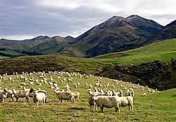
This remains the dominant land use in the Malvern Hills district today. Sheep, beef, and dairy farming are common, alongside arable cropping. Forestry and lifestyle farming have also developed in more recent decades. The area is known for its fertile soils and access to irrigation from Canterbury’s rivers.
Mining
Industrial activity such as lignitecoal mining used to take place in the region. This was one reason as to why the Whitecliffs Branch and other private tramways were built (to Bush Gully and the mines north of Glentunnel), but industrial activity declined sharply in the 20th century and has been effectively non-existent since the 1980s.[5] However, one open-pit coal mine is still operated by Bathurst Resources Limited.[6]
Holm & Bell (2013) note that historic mines in the region, including Homebush (worked 1873–1938) and Klondyke (worked 1929–1972), together produced around 356,000 tonnes of coal from these early mines.[2]
This page is based on this Wikipedia article Text is available under the CC BY-SA 4.0 license; additional terms may apply. Images, videos and audio are available under their respective licenses.