| Mambucaba River | |
|---|---|
 | |
| Location | |
| Country | Brazil |
| Physical characteristics | |
| Source | |
| • location | Rio de Janeiro state |
The Mambucaba River is a river of Rio de Janeiro state in southeastern Brazil. It lies adjacent to the historic village of Mambucaba.
| Mambucaba River | |
|---|---|
| | |
| Location | |
| Country | Brazil |
| Physical characteristics | |
| Source | |
| • location | Rio de Janeiro state |
The Mambucaba River is a river of Rio de Janeiro state in southeastern Brazil. It lies adjacent to the historic village of Mambucaba.

Rio de Janeiro, or simply Rio, is the capital of the state of the same name, Brazil's third most populous state, and the second most populous city in Brazil, after São Paulo. Listed by the GaWC as a beta global city, Rio de Janeiro is the sixth most populous city in the Americas. Part of the city has been designated as a World Heritage Site, named "Rio de Janeiro: Carioca Landscapes between the Mountain and the Sea", on 1 July 2012 as a Cultural Landscape.

Rio de Janeiro is one of the 27 federative units of Brazil. It has the second largest economy of Brazil, with the largest being that of the state of São Paulo. The state, which has 8.2% of the Brazilian population, is responsible for 9.2% of the Brazilian GDP.
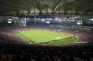
Maracanã Stadium, officially named Estádio Jornalista Mário Filho, is an association football stadium in Rio de Janeiro, Brazil. The stadium is part of a complex that includes an arena known by the name of Maracanãzinho, which means "The Little Maracanã" in Portuguese. Owned by the Rio de Janeiro state government, the stadium is now managed by the clubs Flamengo and Fluminense. It is located at the Maracanã neighborhood, named after the Rio Maracanã, a now canalized river in Rio de Janeiro.
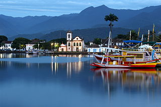
Paraty is a preserved Portuguese colonial (1500–1822) and Brazilian Imperial (1822–1889) municipality with a population of about 43,000. Indeed, the name "Paraty" originates from the local Guaianá Indians' Indigenous Tupi language, inspired by an abundant local fish native to the region. Paraty is located on the Costa Verde, a lush green corridor that runs along the coastline of the state of Rio de Janeiro, in Brazil. Paraty has become a tourist destination, known for its historic town center and the coast and mountains in the region. The historic center of the city, as well as four areas of the Atlantic Forest, were inscribed on UNESCO World Heritage List in 2019 under the title "Paraty and Ilha Grande".

Duque de Caxias is a city on Guanabara Bay and part of Rio de Janeiro metropolitan area, southeastern Brazil.

Cachoeira Paulista is a municipality in the state of São Paulo in Brazil. It is part of the Metropolitan Region of Vale do Paraíba e Litoral Norte, in the Guaratinguetá Microregion.
Volta Redonda is the name of a municipality in the Rio de Janeiro state of Brazil with an area of 182.81 km2, located from 350m to 707m above the sea level and with a population of 273,988 inhabitants. The area around the city has nearly 700,000 km2. Its name is due to the round shape of a curve in the Paraíba do Sul river around which the city was built.
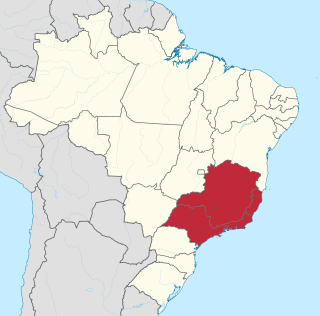
The Southeast Region of Brazil is composed of the states of Espírito Santo, Minas Gerais, Rio de Janeiro and São Paulo. It is the richest region of the country, responsible for approximately 60% of the Brazilian GDP, as São Paulo, Rio de Janeiro, and Minas Gerais are the three richest states of Brazil, the top three Brazilian states in terms of GDP. The Southeast of Brazil also has the highest GDP per capita among all Brazilian regions.

Nova Iguaçu is a municipality in Rio de Janeiro state in Brazil.

Jacarezinho is a Brazilian neighborhood and also a favela with more than 60,300 residents living in an area of 40 ha. The place is located in the North Zone of Rio de Janeiro city, and it borders the neighborhoods of Jacaré, Méier, Engenho Novo and Triagem. It is the third largest favela in Rio de Janeiro, only behind Rocinha and Complexo do Alemão. The favela expanded along with the city's industrialization, and it became the biggest favela in Rio de Janeiro by the mid-20th century, with a population of 23,000 in 1960. The crucial element in its growth was the industrial boom in the nearby Méier district after World War II, according to historian by Julio César Pino, author of a book about the favelas of Rio de Janeiro.

The Academia Militar das Agulhas Negras is the biggest among several schools of formation of combatant officers of the Brazilian Army. It originated in 1792 with the creation of the Royal Academy of Artillery, Fortification and Drawing, the first military school of the Americas, in the city of Rio de Janeiro. Today the Academy is located in the city of Resende, in the state of Rio de Janeiro.

Barreiras is a city located in the west of the state of Bahia, Brazil. It is the most important urban, political, technological and economic center of the western region of the state. Its economy is based on livestock raising and agriculture. In recent years it has experienced an economic boom and is one of the fastest-growing cities in the state of Bahia if not in Brazil.
The Federal Rural University of Rio de Janeiro is a public university located in Seropédica in the State of Rio de Janeiro, Brazil. It possesses the largest campus among Latin American universities and is known for being the first university to offer agriculture related courses in Brazil.
The Barra Mansa River is a river of Rio de Janeiro state in southeastern Brazil.
The Barreiro de Baixo River is a river of Rio de Janeiro state in southeastern Brazil.
The Piranema River is a river of Rio de Janeiro state in southeastern Brazil.
Pavuna is a neighbourhood in the North Zone of Rio de Janeiro, Brazil. It is one of the oldest places in Rio de Janeiro.
The Rio de Janeiro Brazil is a temple of the Church of Jesus Christ of Latter-day Saints in Rio de Janeiro, Brazil. It is the eighth dedicated temple in Brazil.

The Tamoios Environmental Protection Area is an environmental protection area of the state of Rio de Janeiro, Brazil. It protects an area of coastal forests, mangroves, rocky shores and islands.
Coordinates: 23°01′37″S44°31′16″W / 23.02694°S 44.52111°W