Mambucaba

Last updated
Mambucaba
Mambucaba8.jpg
Rua das Flores
Bandeira de Angra dos Reis.png
Brasao de Angra dos Reis.png
RiodeJaneiro Municip AngradosReis.svg
Location in the state of Rio de Janeiro and Brazil
Brazil State RiodeJaneiro.svg
Coordinates: 23°01′37″S44°31′16″W / 23.02694°S 44.52111°W / -23.02694; -44.52111
Country Brazil
Region Southeast
State Rio de Janeiro
Founded1619
Elevation
6 m (20 ft)
Population
  Total700
Time zone UTC-3 (UTC-3)
  Summer (DST) UTC-2 (UTC-2)

The Historic village of Mambucaba is located in the 4th district of the municipality of Angra dos Reis, on the west coast of the state of Rio de Janeiro, Brazil. [1] In the former headquarters of the district of Mambucaba, currently recognized as historical village, [2] are the districts of Parque Mambucaba (Perequê), Praia Vermelha, Residential village of Praia Brava and Boa Vista. Across the Mambucaba River, near the village, lies the Mambucaba Residential Village (formerly known as Parada Beach) and the Batanguera Beach (now known as Coqueiro or Morrinho).

Contents

The access to the village is by Rodovia Governador Mário Covas, also known as Rio-Santos highway.

History

The first record of Mambucaba may be the Tamoio village of Mambucaba, which is cited in the 1557 book História Verídica e Descrição de uma Terra de Selvagens by the German mercenary Hans Staden, [3] which established contact with the local Indians in the 16th century. Faced with the occupation of the region by the Portuguese in that century, the Indians would have remained on the south bank of the river, where they would frequently attack the Portuguese who settled on the north bank (site of the present village). The Portuguese were forced to maintain vigilance in the face of the threat. The Europeans remained there and established an important point of whale hunting for the production of whale oil. It is worth noting that these places were of such importance to the Kingdom of Portugal that their establishment could be only authorized by the king himself. [3]

From the end of the 18th to the 19th century, the village was an important exporter of coffee and importer of slaves to the Vale do Paraíba, located at the mouth of the Mambucaba River, since those who were brought to the municipality of Rio de Janeiro, came in vessels to the islands situated in front of the village and, there, their screening and forwarding to the farms inland was done. House were built in the village during the Golden Age of coffee plantation, a church dedicated to Our Lady of the Rosary, reasonable commerce activity, with records of an establishment for a Vice consul of France.

With the decadence of the port, after the railway connection between São Paulo and Rio de Janeiro in 1872, the village went through decades of abandonment and economic lethargy. In 1968, it was listed by the National Institute of Historic and Artistic Heritage — IPHAN, the historic village of Mambucaba is one of the Brazilian historical sites that were listed in its entirety, not only the buildings, with the urban layout and equipment related to the occupation of the site as well.

The construction of the Rio-Santos highway in the early 1970s threatened the village, generating several protests of cultural movements of the society in Angra dos Reis. In that decade, the existing police station was deactivated, and a military police company installed in barracks on the edge of the highway, now with the purpose of providing protection to the construction works of the nuclear power plant.

Etymology

The name, of indigenous origin, has a controversial meaning. Some people claim that it derives from Mambuca, a small stingless bee better known as "Japurá", a bee-dog abundant in the region. Some others refer to a very abundant plant in the region. There are still others who advocate the meaning as "passage". This last interpretation seeks origin in the fact that, by bordering the river, we have a path that was already used by the Indians of the region as means of connection with the Planalto Paulista. This path came to have long rocky sidewalks built by African slaves for disposal of coffee production.[ citation needed ]

The name "Mambucaba" also designates the river that finds the sea, having its source in the state of São Paulo, within the Serra da Bocaina National Park, in the municipality of São José do Barreiro. Within the Fluminense territory, the river marks the boundary between the municipalities of Angra dos Reis and Paraty. With this, according to historian Alípio Mendes, the name Mambucaba can also mean "sea loch", since the Mambucaba river waters into the sea, as if it were an extension of it. [4]

Village and neighborhood

Nowadays, the old village, which keeps much of its colonial houses, is a point of vacationers that come from other regions of the west of the state of Rio de Janeiro, the city of Rio de Janeiro and the state of São Paulo. It has about 700 inhabitants, reaching approximately 10,000 visitors in the summer. Its infrastructure has had great improvements in recent years, having practically all streets received pavement and public lighting. A health post and a school are also offered to the local population by the municipality of Angra dos Reis.

There is also residential villages maintained by the Eletrobras, the state energy company for employees of the Angra Nuclear Power Plant. In the neighborhood, Parque Mambucaba, known until a few years ago as Perequê (which means "Path of ascent of the fish", due to the mangrove areas on its shores where the fish reproduce), reside around 21000 people, population that multiply on weekends and holidays during the summer months, when the influx of people come mainly from the region of Vale do Paraíba, and those who have summer residences there. In the last 15 years, this neighborhood has won a reasonable infrastructure for the trade and provision of public and private services, since many workers and former workers of the nuclear power plant resolved to reside permanently, due to the proximity of other localities with access to the sea, as well as the ease of access to Rodovia Rio-Santos.

This region is attended, in relation to public security and civil defense, by the 33 battalion of Military police, whose headquarters is located at the entrance of Parque Mambucaba, and by the 1st Detachment of the 26th group of Military Fireman, located in the working village. Another hospital is located in the neighborhood of Praia Brava and is maintained by Eletronuclear. There are other health posts and a detachment of the Municipal Civil Defense of Angra dos Reis held in Mambucaba Park.

Related Research Articles

<span class="mw-page-title-main">Santos, São Paulo</span> Municipality in São Paulo, Brazil

Santos, officially Municipality of Estancia Balneária de Santos is a municipality in the Brazilian state of São Paulo, founded in 1546 by the Portuguese nobleman Brás Cubas. It is located mostly on the island of São Vicente, which harbors both the city of Santos and the city of São Vicente, and partially on the mainland. It is the main city in the metropolitan region of Baixada Santista. The population is 433,656 in an area of 280.67 km2 (108.37 sq mi). The city is home to the Coffee Museum, where world coffee prices were once negotiated. There is also a football memorial, dedicated to the city's greatest players, which includes Pelé, who spent the majority of his career with Santos Futebol Clube. Its beachfront garden, 5,335 m (5,834 yd) in length, figures in Guinness World Records as the largest beachfront garden in the world.

<span class="mw-page-title-main">Paraty</span> Historic municipality in Brazil

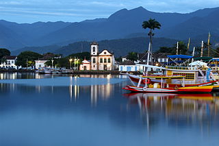
Paraty is a preserved Portuguese colonial (1500–1822) and Brazilian Imperial (1822–1889) municipality with a population of about 43,000. The name "Paraty" originates from the local Guaianá Indians' indigenous Tupi language, named for an abundant local fish native to the region. Paraty is located on the Costa Verde, a lush green corridor that runs along the coastline of the state of Rio de Janeiro, in Brazil. Paraty has become a tourist destination, known for its historic town center and the coast and mountains in the region. The historic center of the city, as well as four areas of the Atlantic Forest, were inscribed on the UNESCO World Heritage List in 2019 under the title "Paraty and Ilha Grande".

<span class="mw-page-title-main">São José dos Campos</span> Municipality in Southeast, Brazil

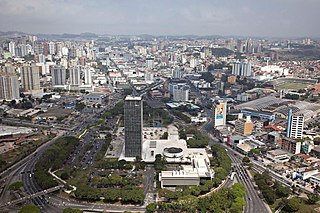
São José dos Campos is a major city and the seat of the municipality of the same name in the state of São Paulo, Brazil. One of the leading industrial and research centers with emphasis in aerospace sciences in Latin America, the city is located in the Paraíba Valley, between the two most active production and consumption regions in the country; São Paulo and Rio de Janeiro. It is the main city of the Metropolitan Region of Vale do Paraíba e Litoral Norte. A native of São José dos Campos is called a joseense. Being the second most populous non-capital city in Brazil – behind Campinas – São José dos Campos lies in the middle of the Expanded Metropolitan Complex, the first megalopolis in the Southern Hemisphere, with over thirty million inhabitants. The city's metro area also includes Greater São Paulo, Campinas, Santos and Sorocaba. The municipality concentrates many major companies and industries, such as Embraer, Panasonic, Johnson & Johnson, Ericsson, Philips, General Motors, Petrobras, Monsanto among others. São José dos Campos also holds relevant education and research institutions, as ITA, INPE, CEMADEN, IEAv, IEA, IFI, UNESP, UNIFESP, DCTA, FATEC, UNIVAP and IP%D, holding a position the puts the city as the main and largest Aerospacial Complex in Latin America. Thus, it is also considered the warlike producer centre. The Technological Park, the largest one in the country, is the only research institute in the world that converges all the three top global plane production companies, Embraer, Boeing and Airbus.

<span class="mw-page-title-main">Bananal, São Paulo</span> Municipality in the state of São Paulo in Brazil

Município da Estância Turística de Bananal is a city in the state of São Paulo in Brazil. It is part of the Metropolitan Region of Vale do Paraíba e Litoral Norte. The population is 10,993 in an area of 616.43 km2 (238.00 sq mi).

<span class="mw-page-title-main">Duque de Caxias, Rio de Janeiro</span> Municipality in Southeast, Brazil

Duque de Caxias is a city on Guanabara Bay and part of Rio de Janeiro metropolitan area, southeastern Brazil.

<span class="mw-page-title-main">Cachoeira Paulista</span> Municipality in Southeast Brazil, Brazil

Cachoeira Paulista is a municipality in the state of São Paulo in Brazil. It is part of the Metropolitan Region of Vale do Paraíba e Litoral Norte, in the Guaratinguetá Microregion.

<span class="mw-page-title-main">Itanhaém</span> Municipality in Southeast, Brazil

Itanhaém is a municipality in the state of São Paulo in Brazil. It is part of the Metropolitan Region of Baixada Santista. The population is 103,102 in an area of 601.85 km². The elevation is 4 m.

<span class="mw-page-title-main">Paraíba Valley</span>

The Paraíba Valley is a landform that encompasses the regions: Paraíba Valley Metropolitan Region and Northern Coast, in the state of São Paulo and Sul-Fluminense Region, in the state of Rio de Janeiro, which stands out for concentrating a considerable portion of the Brazilian economy.

<span class="mw-page-title-main">Resende, Rio de Janeiro</span> Municipality in Southeast, Brazil

Resende is a municipality located in the Brazilian state of Rio de Janeiro. The population is 132,312 in an area of 1094 km2. Resendense refers to people or things that come from or inhabit Resende. It is the oldest town in this region, which has boundaries with the state of São Paulo and Minas Gerais. It is an important industrial, automotive, metallurgical, and tourist center, and headquarters of the world's second-largest military complex, the Academia Militar das Agulhas Negras (AMAN). Resende is of national importance and houses the Nuclear Fuel Factory complex of the "Indústrias Nucleares" of Brasil, the only one able to enrich uranium. Resende's automotive area holds MAN Latin America, the biggest truck and bus factory of Brazil, limited to PSA Peugeot Citroën and Michelin.

<span class="mw-page-title-main">BR-101 (Brazil highway)</span> Highway in Brazil

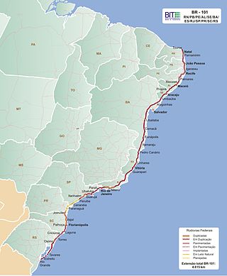
The BR-101 is a longitudinal highway of Brazil. It is the longest in the country with a length of nearly 4,800 km (3,000 mi), and it is considered one of the most important highways in the country, along with BR-116.

<span class="mw-page-title-main">Brazilian Highway System</span> Highway system of Brazil

The Brazilian Highway System is a network of trunk roads administered by the Ministry of Transport of Brazil. It is constructed, managed and maintained by the National Department of Transport Infrastructure (DNIT), federal agency linked to the Ministry of Infrastructure, and the public works departments of state governments.

<span class="mw-page-title-main">Angra dos Reis</span> Municipality in Rio de Janeiro state, Brazil

Angra dos Reis is a municipality located in the southern part of the Brazilian state of Rio de Janeiro. The city is located by the sea and includes in its territory many offshore islands, the largest being Ilha Grande.

<span class="mw-page-title-main">São Bernardo do Campo</span> Municipality in Southeast, Brazil

São Bernardo do Campo is a Brazilian municipality in the state of São Paulo.

<span class="mw-page-title-main">Rodovia Presidente Dutra</span> Highway in Brazil

The Rodovia Presidente Dutra,, colloquially known as Via Dutra is a federal highway which runs through the eastern part of the state of São Paulo and southwestern region of the state of Rio de Janeiro. It is the part of the route BR-116 connecting the city of São Paulo to the city of Rio de Janeiro.

Costa Verde is a coastline in Brazil, which runs from Itaguaí, Rio de Janeiro state, to Santos, São Paulo state. In São Paulo it is known as litoral norte. Brazil's Costa Verde is characterized by the Serra do Mar escarpment reaching Atlantic Ocean, creating a mountainous landscape very near the coast. It can be considered the greatest extension of Atlantic Forest biome reaching the ocean, between Baixada Fluminense and Baixada Santista.

<span class="mw-page-title-main">Aventureiro Sustainable Development Reserve</span> Sustainable Development Reserve in Rio de Janeiro

The Aventureiro Sustainable Development Reserve, formerly the Aventureiro Marine State Park, is a sustainable development reserve in the state of Rio de Janeiro, Brazil. It supports artisanal fishing by a small traditional community on the Ilha Grande, an island off the southwest coast of the state.

<span class="mw-page-title-main">Ilha Grande State Park</span>

The Ilha Grande State Park is a state park in the state of Rio de Janeiro, Brazil.

<span class="mw-page-title-main">Tamoios Environmental Protection Area</span> Protected area in Rio de Janeiro, Brazil

The Tamoios Environmental Protection Area is an environmental protection area of the state of Rio de Janeiro, Brazil. It protects an area of coastal forests, mangroves, rocky shores and islands.

<span class="mw-page-title-main">Captaincy of Rio de Janeiro</span> Former territorial division of Brazil

The Captaincy of Rio de Janeiro was formed in the northern portion of the Captaincy of São Vicente, in a territory that extended from Macaé to Caraguatatuba. This part of the Captaincy had been abandoned by its donatário Martim Afonso de Sousa, who was never interested in its settlement and focused his attention and resources on the area of the current São Paulo coast.

References

  1. Francimar Carlos Pinheiro. "A Relacao Historica da Regiao de Mambucaba/RJ com a Energia Eletrica no Brasil" (PDF). Archived (PDF) from the original on December 23, 2018. Retrieved October 18, 2019.
  2. "Vila Historica de Mambucaba, Angra Dos Reis". Inspirock. Archived from the original on October 18, 2019. Retrieved October 18, 2019.
  3. 1 2 Hans Staden. Duas Viagens ao Brasil. L&PM, Porto Alegre, 2010. p. 83.
  4. "Festival de Marchinha de Mambucaba". Acampamento Base Marins. Archived from the original on October 18, 2019. Retrieved October 18, 2019.
Attribution