
Raetihi, a small town in the centre of New Zealand's North Island, is located at the junction of State Highways 4 and 49 in the Manawatū-Whanganui region. It lies in a valley between Tongariro and Whanganui National Parks, 11 kilometres west of Ohakune's ski fields.

Ōtaki is a town in the Kāpiti Coast District of the North Island of New Zealand, situated halfway between the capital city Wellington, 70 km (43 mi) to the southwest, and Palmerston North, 70 km (43 mi) to the northeast.

Kakahi ) is a small King Country settlement about 10 kilometres (6.2 mi) up the Whanganui River from Taumarunui, New Zealand. Founded as a sawmill town, it takes its name from the Māori word for the New Zealand freshwater mussel.
Ohangai is a locality in South Taranaki, New Zealand. It is approximately 10 km east of Hāwera and 6 km north of Mokoia
Waitōtara is a town in South Taranaki, New Zealand. Waverley is 10 km to the north-west, and Whanganui is 34 km to the south-east. State Highway 3 passes through it. The Waitōtara River flows past the east side of the town.
Mimi is a locality in northern Taranaki, in the North Island of New Zealand. It is located on State Highway 3 close to the shore of the North Taranaki Bight, 6 kilometres north-east of Urenui and 26 km south-west of Ahititi. The Mimi River flows past the settlement into the North Taranaki Bight.
Whatatutu is a small settlement in the northeast of New Zealand's North Island. It is located north of Te Karaka on the upper reaches of the Waipaoa River, close to its meeting with its tributaries, the Mangatu River and Waingaromia River.
Manakau is a settlement situated in the Horowhenua District, located at the boundary of the Manawatū-Whanganui and Wellington regions of New Zealand's North Island. It lies 8 km north of Ōtaki and 12 km south of Levin, and is connected to both via State Highway 1, which skirts Manakau's western edge. The township is situated 5 km inland from the coast of the Tasman Sea.
Matangi is a settlement in the Waikato District on the eastern border of Hamilton. It is surrounded by many lifestyle blocks, but the village centre has Matangi School, a garage, Four Square, takeaway and café, Matangi Hall, St David’s church and Matangi recreation reserve.
Matahi is a rural valley in the Whakatāne District and Bay of Plenty Region of New Zealand's North Island.
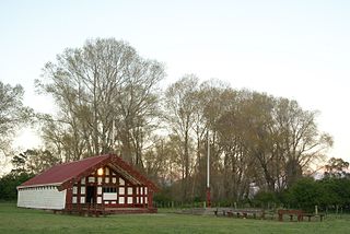
Mangahanea Marae is a marae located in the East Coast township of Ruatoria in New Zealand. The marae is the within the land catchment of the descendants of Māori tribes Ngāti Porou and Ngāti Uepohatu, through the marriage of Hinetapora and Te Rangikaputua. Their descendants are connected to a number of subtribes (hapū): Uepohatu, Te Aitangā o Materoa, Hauiti, Ruataupare and Te Whānau o Umuariki.

Tauwhare is a small rural community in the Waikato District on the outskirts of Hamilton. The Waitakaruru Arboretum and Sculpture Park is located here.
Ohinewai is a small settlement in the Waikato Region, in New Zealand. It is located on the east bank of the Waikato River on SH1, 9 km north of Huntly
Koputaroa, Koputāroa or Kōputaroa is a rural community in the Horowhenua District and Manawatū-Whanganui region of New Zealand's North Island.
Wharerātā or Bartletts is a rural coastal community in the Gisborne District of New Zealand's North Island. It is located on State Highway 2 between Wairoa and Gisborne.
Poroporo is a rural community in the Whakatāne District and Bay of Plenty Region of New Zealand's North Island. It is located south-west of Whakatāne, inland from the settlement.

Omaio is a coastal township in the Ōpōtiki District and Bay of Plenty Region of New Zealand's North Island.
Kutarere is a community in the Ōpōtiki District and Bay of Plenty Region of New Zealand's North Island, on the coast of the Ohiwa Harbour.
Te One is a settlement on the Chatham Islands. It is located in Petre Bay, on the west coast of the main island, just north of the port settlement of Waitangi.
Waiaua or Lower Waiaua is a rural community in the Ōpōtiki District and Bay of Plenty Region of New Zealand's North Island, located around the lower part of the Waiaua River.