
Conshohocken is a borough on the Schuylkill River in Montgomery County, Pennsylvania, in suburban Philadelphia. Historically a large mill town and industrial and manufacturing center, after the decline of industry in recent years Conshohocken has developed into a center of riverfront commercial and residential development. In the regional slang, it is sometimes referred to by the colloquial nickname Conshy. The name "Conshohocken" comes from the Unami language, from either Kanshi'hak'ing, meaning "Elegant-ground- place", or, more likely, Chottschinschu'hak'ing, which means "Big-trough-ground-place" or "Large-bowl-ground-place", referring to the big bend in the Tulpe'hanna.

Roxborough is a neighborhood in the Northwest section of the city of Philadelphia, Pennsylvania. It is bordered to the southwest, along the Schuylkill River, by the neighborhood of Manayunk, along the northeast by the Wissahickon Creek section of Fairmount Park, and to the southeast by the neighborhood of East Falls. Beyond Roxborough to the northwest is Montgomery County. Roxborough's ZIP code is 19128. Most of Roxborough is in Philadelphia's 21st Ward.

The Schuylkill River is a river running northwest to southeast in eastern Pennsylvania, which was improved by navigations into the Schuylkill Canal. Several of its tributaries drain major parts of the center-southern and easternmost Coal Regions in the state. It flows for 135 miles (217 km) from Pottsville to Philadelphia, where it joins the Delaware River as one of its largest tributaries.

The Union Canal was a towpath canal that existed in southeastern Pennsylvania in the United States during the 19th century. First proposed in 1690 to connect Philadelphia with the Susquehanna River, it ran approximately 82 mi from Middletown on the Susquehanna below Harrisburg to Reading on the Schuylkill River.

Manayunk is a neighborhood in the section of Lower Northwest Philadelphia in the state of Pennsylvania. Located adjacent to the neighborhoods of Roxborough and Wissahickon and also on the banks of the Schuylkill River, Manayunk contains the first canal begun in the United States. The area's name is derived from the language of the Lenape Indians. In 1686-dated papers between William Penn and the Lenape, the Lenape referred to the Schuylkill River as "Manaiung", their word for "river", which literally translates as "place to drink"; the word was later altered and adopted as the town's name.
The Schuylkill Expressway, locally known as "the Schuylkill" or "the Skook", is a two to eight lane freeway through southwestern Montgomery County and the city of Philadelphia, and the easternmost segment of Interstate 76 (I-76) in the U.S. state of Pennsylvania. It extends from the Valley Forge exit of the Pennsylvania Turnpike in King of Prussia, paralleling its namesake Schuylkill River for most of the route, to the Walt Whitman Bridge in South Philadelphia. It serves as the primary corridor into Philadelphia from points west. Maintenance and planning are administered through Pennsylvania Department of Transportation (PennDOT) District 6. Constructed over a period of ten years from 1949 to 1959, a large portion of the expressway predates the 1956 introduction of Interstate Highway System; many of these portions were not built to contemporary standards. The rugged terrain, limited riverfront space covered by the route and narrow spans of bridges passing over the highway have largely stymied later attempts to upgrade or widen the highway. With the road being highly over capacity, it has become notorious for its chronic congestion. An average of 163,000 vehicles use the road daily in Philadelphia County, and an average of 109,000 use the highway in Montgomery County, making it the busiest road in Pennsylvania. Its narrow lane and left shoulder configuration, left lane entrances and exits, common construction activity and generally congested conditions have led to many accidents, critical injuries and fatalities, leading to the highway's humorous nickname of the "Surekill Expressway" or in further embellishment, the "Surekill Distressway" or the “Surekill Crawlway".

Norristown Transportation Center is a two-level multimodal public transportation regional hub located in Norristown, Pennsylvania, USA, operated by SEPTA. It opened in 1989 to replace the older Norristown High Speed Line terminus one block away at Main and Swede Streets, and integrated the former Reading Company DeKalb Street Norristown railroad station into its structure. A plaque embedded in the sidewalk commemorates the location of one of the columns of the dismantled segment of the Philadelphia and Western Railroad (P&W) trestle.
The Schuylkill Valley Metro (SVM) was a proposal for a 62-mile railway system that would link Philadelphia, Pennsylvania with the city of Reading, Pennsylvania in central Berks County, using the SEPTA Manayunk/Norristown Line and Cynwyd Line, plus two Norfolk Southern Railway freight-only lines. The proposal was rejected by the Federal Transit Administration; there are no plans to move forward with the project.
The Schuylkill Canal, or Schuylkill Navigation, was a system of interconnected canals and slack-water pools along the Schuylkill River in the U.S. state of Pennsylvania, built as a commercial waterway in the early 19th-century. Chartered in 1815, the navigation opened in 1825 to provide transportation and water power. At the time, the river was the least expensive and most efficient method of transporting bulk cargo, and the eastern seaboard cities of the U.S. were experiencing an energy crisis due to deforestation. It fostered the mining of anthracite coal as the major source of industry between Pottsville and eastern markets. Along the tow-paths, mules pulled barges of coal from Port Carbon through the water gaps to Pottsville; locally to the port and markets of Philadelphia; and some then by ship or through additional New Jersey waterways, to New York City markets.

East Falls is a neighborhood in the Northwest section of Philadelphia, Pennsylvania, United States. It lies on the east bank of the "Falls of the Schuylkill," cataracts submerged in 1822 by the Schuylkill Canal and Fairmount Water Works projects. East Falls sits next to the Germantown, Roxborough, Allegheny West, and Nicetown-Tioga neighborhoods, and to Wissahickon Valley Park. The neighborhood runs along a few miles of Ridge Avenue, along the banks of the Schuylkill River then extends northeast to Wissahickon Avenue. It overlooks the multi-use recreational path of Fairmount Park along Kelly Drive, and is desirable for its central location, an easy commute to Center City with easy access to several major roadways and public transportation.

The Delaware Division of the Pennsylvania Canal, more commonly called the Delaware Canal, runs for 60 miles (97 km) parallel to the right bank of the Delaware River from the entry locks near the mouth of the Lehigh River and terminal end of the Lehigh Canal at Easton south to Bristol. At Easton, which today is the home of The National Canal Museum, the Delaware Canal also connected with the Morris Canal built to carry anthracite coal to energy starved New Jersey industries. Later, with a crossing-lock constructed at New Hope, the New Hope 'outlet lock' (1847) connected by Cable Ferry to enter at Lambertville, NJ; where it connected to a feeder navigation/canal that began at Bull's Island opposite Lumberville; which then ran over 22 miles (35 km) south along the New Jersey bank of the Delaware River through Trenton to Bordentown, the west end of the Delaware and Raritan Canal (1834) to New York City via New Brunswick. The Commonwealth of Pennsylvania built the Delaware canal to feed anthracite stone coal to energy-hungry Philadelphia as part of its transportation infrastructure building plan known as the Main Line of Public Works—a legislative initiative creating a collection of self-reinforcing internal improvements to commercial transportation capabilities.

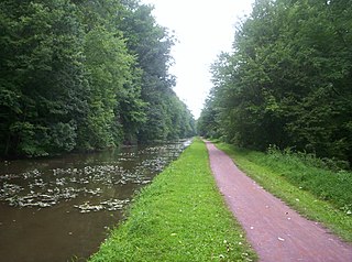
The Schuylkill River Trail is a multi-use trail along the banks of the Schuylkill River in southeastern Pennsylvania. Partially complete as of 2018, the trail is ultimately planned to run about 140 miles (230 km) from the river's headwaters in Schuylkill County to Fort Mifflin in Philadelphia.

The Lehigh Canal or the Lehigh Navigation Canal is a navigable canal, beginning at the mouth of Nesquehoning Creek on the Lehigh River in Eastern Pennsylvania. It was built in two sections over a span of twenty years, beginning in 1818. The lower section spanned the distance between Easton, Pennsylvania and the town of Mauch Chunk, present-day Jim Thorpe, Pennsylvania. In Easton the canal met the Delaware and Morris Canals, with which goods could be brought further up the east coast. At its height, the Lehigh Canal was 72 miles (116 km) long.
Delaware Canal State Park is a 830-acre (336 ha) Pennsylvania state park in Bucks and Northampton Counties in Pennsylvania in the United States. The main attraction of the park is the Delaware Canal which runs parallel to the Delaware River between Easton and Bristol.

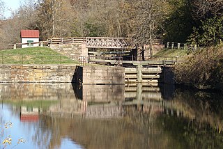
The Schuylkill Canal Association (SCA) is a non-governmental organization that maintains the Oakes Reach and Lock #60 of the Schuylkill Canal as a public recreation area and historical site. Organized in 1982 as the Schuylkill Canal Advisory Board, the Association, in cooperation with Upper Providence Township, Montgomery County, and the Commonwealth of Pennsylvania, maintains the canal reach, associated structures, parks and trails. The area extends along the canal and left bank of the Schuylkill River, from Mont Clare past Port Providence. The area makes up a large part of the Schuylkill Navigation Canal, Oakes Reach Section Historic District (#88000462).

The Manayunk Bridge is an S-shaped former railroad bridge over the Schuylkill River, Schuylkill Canal and Schuylkill Expressway, that connects Bala Cynwyd, Montgomery County and the Manayunk neighborhood of Philadelphia, Pennsylvania. Closed to rail traffic in 1986, it is now an extension of the Cynwyd Heritage Trail and connects to the Schuylkill River Trail.

The Cynwyd Line is a SEPTA Regional Rail line running from Center City Philadelphia to Cynwyd in Montgomery County. Originally known as the Ivy Ridge Line, service was truncated on May 17, 1986, at its current terminus at Cynwyd. Track between Cynwyd and Ivy Ridge was dismantled between 2008 and 2010 for conversion as an interim rail trail, preventing service restoration for the foreseeable future. The Cynwyd line is the shortest of the SEPTA regional rail lines, and is the second shortest regional rail line in the United States, with only the New Jersey Transit Princeton Branch being shorter. It is by far the least ridden and least trafficked SEPTA Regional Rail Line. It is fully grade-separated.

The Manayunk/Norristown Line is a commuter rail line in Southeastern Pennsylvania, and one of the 13 lines in SEPTA's Regional Rail network.
The Manayunk Expressway was a proposed parkway that was to run along the east bank of the Schuylkill River similar to the Moses parkways of New York City, first proposed in 1932 by the Regional Planning Federation. It was originally designed to connect Fairmount Park in Philadelphia with Norristown. The purpose was to have served as an alternate route to the Schuylkill Expressway and Germantown Pike that by 1960 had become congested.
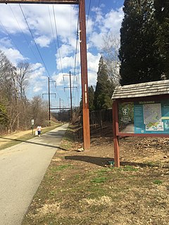
The Cynwyd Heritage Trail is a 1.8-mile rail trail in Lower Merion, Pennsylvania, on Philadelphia's Main Line. The trail surface is partially asphalt and crushed stone.
