
U.S. Route 90 or U.S. Highway 90 (US 90) is an east–west major United States highway in the Southern United States. Despite the "0" in its route number, US 90 never was a full coast-to-coast route. It generally travels near Interstate 10 (I-10) and passes through the southern states of Texas, Louisiana, Mississippi, Alabama, and Florida. US 90 also includes part of the DeSoto Trail between Tallahassee and Lake City, Florida.
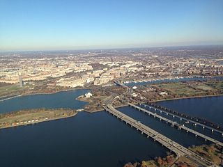
The 14th Street bridges refers to the three bridges near each other that cross the Potomac River, connecting Arlington, Virginia and Washington, D.C. Sometimes the two nearby rail bridges are included as part of the 14th Street bridge complex. A major gateway for automotive, bicycle and rail traffic, the bridge complex is named for 14th Street, which feeds automotive traffic into it on the D.C. end.
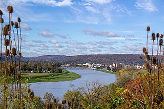
The Chemung River is a tributary of the Susquehanna River, approximately 46.4 miles (74.7 km) long, in south central New York and northern Pennsylvania in the United States. It drains a mountainous region of the northern Allegheny Plateau in the Southern Tier of New York. The valley of the river has long been an important manufacturing center in the region but has suffered a decline in the late 20th century.
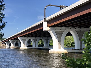
The Scudder Falls Bridge is a toll bridge that carries Interstate 295 (I-295) over the Delaware River, connecting Lower Makefield Township in Bucks County, Pennsylvania, with the Scudders Falls section of Ewing Township in Mercer County, New Jersey, United States. It is maintained by the Delaware River Joint Toll Bridge Commission (DRJTBC). The original bridge was a plate girder bridge constructed from 1958 to 1961, and the current structure is a box-girder bridge that partially opened in 2019 and was substantially complete in 2021. Previously, the bridge was a toll-free crossing. However, this changed on July 14, 2019, when an all-electronic toll was levied for Pennsylvania-bound traffic; the toll can be paid using E-ZPass or Toll-by-Plate.

Manchester is a former independent city in Virginia in the United States. Prior to receiving independent status, it served as the county seat of Chesterfield County, between 1870 and 1876. Today, it is a part of the city of Richmond, Virginia.

The Richmond Staples Mill Road Amtrak station is located in unincorporated Henrico County, Virginia, about 5 miles (8 km) north of downtown Richmond. The station was designed by David Volkert and Associates, and was built in 1975 as a replacement for Main Street Station in downtown Richmond, which had been heavily damaged by flooding from Hurricane Agnes. At its opening, it also inherited trains that had called at Richmond's other former union station, Broad Street Station, with a bus connection to the short-lived Richmond–Ellerson Street Station. Although limited Amtrak service returned to Main Street Station in December 2003, Staples Mill Road remains the primary rail station for the Richmond area, and all Richmond trains make a stop there. Richmond Main Street Station only sees trains that terminate there or at Newport News, since the other trains bypass downtown Richmond to the west.
The Robert E. Lee Memorial Bridge in Richmond, Virginia carries U.S. Route 1 and U.S. Route 301 across the James River at the Fall Line.

The George Massey Tunnel is a highway traffic tunnel in the Metro Vancouver region of southwestern British Columbia. It is located approximately 20 km (12.4 mi) south of the city centre of Vancouver, British Columbia, and approximately 30 km (18.6 mi) north of the Canada–United States border at Blaine, Washington.

Boulevard Bridge in the independent city of Richmond, Virginia is a toll bridge which carries State Route 161 across the James River.

Huguenot Memorial Bridge is located in Henrico County and the independent city of Richmond, Virginia. It carries State Route 147 across the former Chesapeake and Ohio Railway, the James River and Kanawha Canal, and the James River in the Fall Line region above the head of navigation at Richmond.
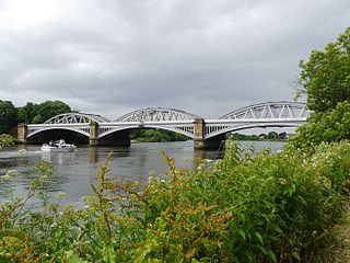
Barnes Railway Bridge is a Grade II listed railway bridge in the London Borough of Richmond upon Thames and the London Borough of Hounslow. It crosses the River Thames in London in a northwest to southeast direction at Barnes. It carries the South Western Railway's Hounslow Loop Line, and lies between Barnes Bridge and Chiswick stations. It can also be crossed on foot, and is one of only three bridges in London to combine pedestrian and rail use; the others being Hungerford Bridge and Golden Jubilee Bridges and Fulham Railway Bridge.

The Walnut Street Bridge also known as The People's Bridge, is a truss bridge that spanned the Susquehanna River in Harrisburg, Pennsylvania until 1996. Built by the Phoenix Bridge Company in 1890, it is the oldest remaining bridge connecting Harrisburg's downtown and Riverfront Park with City Island. Since flooding in 1996 collapsed sections of the western span, it no longer connects to the West Shore. The bridge was added to the National Register of Historic Places in 1971. A 2014 Cross-River Connections Study notes that the bridge currently serves as an "important bicycle and pedestrian link between City Island and downtown Harrisburg, connecting the city and the Capital Area Greenbelt to special events on City Island."
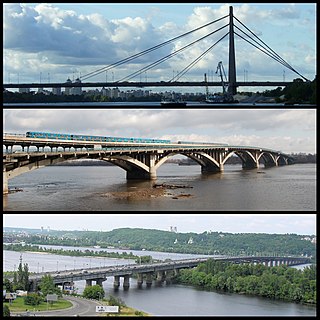
Kyiv, historically situated on the right bank of the Dnieper River, now covers both banks of the river whose width, as it flows through the city, reaches several hundred metres. Additionally, several tributaries join the Dnieper inside or just north or south of the historic city. Currently there are eight bridges spanning across the river and a few dozen bridges across the canals and Dnieper tributaries.

The Dinsmore Bridge is a crossing over the middle arm of the Fraser River, and a former section of River Rd., in Metro Vancouver.

Vodootvodny Canal is a 4 kilometre long, 30-60 metre wide canal in downtown Moscow, Russia. It was built in the 1780s on the old riverbed of the Moskva River to control floods and support shipping. Canal construction created an island between the Moskva River and the canal. The island acquired its present shape in 1938 with the completion of Moscow Canal megaproject. The canal is spanned by ten bridges; the eleventh is now under construction.
The No. 2 Road Bridge is a crossing over the middle arm of the Fraser River, and River Rd., in Metro Vancouver.

Mayo's Bridge is located in Richmond, Virginia. A four lane structure, it transports U.S. Route 360 across the James River. Signage identifies the bridge as "Mayo's Bridge".

The James River Bridge carries Interstate 95 across the James River in Richmond, Virginia.

The Brown's Island Dam Walk, also known as the VEPCO Levee Dam is a structure across the James River in Richmond, Virginia that connects Brown's Island to the James River Parks System on the Manchester side of the river. It was originally constructed as a dam in 1901 by the Virginia Electric and Power Company (VEPCO). The original purpose for the 31.5 ft (9.6 m) tall structure was to divert water into the Haxall Canal where it was received by the 12th Street Power Station until its decommissioning in 1968. The bridge has been renamed the T. Tyler Potterfield Memorial bridge after a senior planner in the Richmond Department of Planning and Development Review who was the project manager for the bridge's redevelopment into a pedestrian bridge.

The Chelsea Street Bridge is a bridge in South Royalton, Vermont, spanning over the White River. The original bridge was constructed in 1848, followed by several replacements. The current bridge was completed in 2002.


