Related Research Articles

Chesterfield County is a county located just south of Richmond in the Commonwealth of Virginia. The county's borders are primarily defined by the James River to the north and the Appomattox River to the south. Its county seat is Chesterfield Court House.

Manchester is a former independent city in Virginia in the United States. Prior to receiving independent status, it served as the county seat of Chesterfield County, between 1870 and 1876. Today, it is a part of the city of Richmond, Virginia.

The Chesterfield Railroad was located in Chesterfield County, Virginia. It was a 13-mile (21-kilometer) long mule-and-gravity powered line that connected the Midlothian coal mines with wharves that were located at the head of navigation on the James River just below the Fall Line at Manchester. It began operating in 1831 as Virginia's first common carrier railroad.
The Richmond–Petersburg Turnpike was a toll road located in the Richmond-Petersburg region of central Virginia, United States.
Midlothian, Virginia is an unincorporated area in Chesterfield County, Virginia, U.S. Settled as a coal town, Midlothian village experienced suburbanization effects and is now part of the western suburbs of Richmond, Virginia south of the James River in the Greater Richmond Region. Because of its unincorporated status, Midlothian has no formal government, and the name is used to represent either the original small Village of Midlothian, located near US-60 and Woolridge Road, or a vast expanse of Chesterfield County in the northwest portion of Southside Richmond covered by three zip codes served by the Midlothian post office. These zip codes are not coterminous with the Midlothian Magisterial District associated with the Chesterfield County government.

State Route 76 is a state highway in the U.S. state of Virginia. Known as Powhite Parkway, the state highway runs 13.04 miles (20.99 km) from SR 652 near Midlothian north to Interstate 195 (I-195) in Richmond. SR 76 is a toll freeway that connects SR 288, U.S. Route 60, and SR 150 in Chesterfield County with I-195 and SR 195 west of Downtown Richmond. The highway includes a pair of mainline barrier toll plazas and ramp toll plazas at most interchanges, all of which accept E-ZPass. SR 76 is maintained by the Virginia Department of Transportation (VDOT) in Chesterfield County and the Richmond Metropolitan Authority in the city of Richmond. The Richmond section of the freeway was constructed in the early 1970s; the highway was extended to its current terminus in Chesterfield County in the late 1980s.

State Route 150 is a state highway in the U.S. state of Virginia. Known as Chippenham Parkway, the state highway runs 15.19 miles (24.45 km) from Interstate 95 (I-95) and SR 895 in Bensley north to Parham Road and River Road near Tuckahoe in Henrico County. SR 150 is a four- to six-lane circumferential highway that connects the Chesterfield County suburbs of Richmond with western Henrico County and, via SR 895, eastern Henrico County and Richmond International Airport. The highway is a freeway except for a short stretch east of SR 147 in Richmond. SR 150 has junctions with all of the radial highways south of the James River, including I-95, U.S. Route 1, US 301, US 360, US 60, and SR 76.

Falling Creek is a tributary of the James River located near Richmond, Virginia. Approximately 23 miles (37 km) in length, it varies in width between 10 feet (3.0 m) at its source to several hundred feet in the Falling Creek Reservoir. Falling Creek rises in the Salisbury section of northwestern Chesterfield County, flows through Southside Richmond and empties into the James River roughly one mile south of the Richmond city limits. A dam located in the Meadowbrook section of the county at Hopkins Road forms the Falling Creek Reservoir, formerly used as northern Chesterfield's drinking water supply.
The Southside of Richmond is an area of the Metropolitan Statistical Area surrounding Richmond, Virginia. It generally includes all portions of the City of Richmond which lie south of the James River, and includes all of the former city of Manchester. Depending on context, the term "Southside of Richmond" can include some northern areas of adjacent Chesterfield County, Virginia in the Richmond-Petersburg region. With minor exceptions near Bon Air, VA, the Chippenham Parkway forms the border between Chesterfield County and the City of Richmond portions of Southside, with some news agencies using the term "South Richmond" to refer to the locations in Southside located in the city proper.

Transportation in Richmond, Virginia and its immediate surroundings include land, sea and air modes. This article includes the independent city and portions of the contiguous counties of Henrico and Chesterfield. While almost all of Henrico County would be considered part of the Richmond area, southern and eastern portions of Chesterfield adjoin the three smaller independent cities of Petersburg, Hopewell, and Colonial Heights, collectively commonly called the Tri-Cities area. A largely rural section of southwestern Chesterfield may be considered not a portion of either suburban area.
Chesterfield County Public Schools is the public school system of Chesterfield County, Virginia, United States. As of 2015, there are about 59,000 students enrolled in 63 schools. There are 38 elementary schools, 12 middle schools, and 11 high schools Additionally, high school students can enroll in 13 specialty centers, two technical centers, and two Governor's Schools.

The Richmond and Petersburg Railroad moved passengers and goods between Richmond and Petersburg from 1838 to 1898. It survived the American Civil War and eventually merged into the Atlantic Coast Line Railroad in 1900.
U.S. Route 60 (US 60) in the Commonwealth of Virginia runs 303 miles (488 km) west to east through the central part of the state, generally close to and paralleling the Interstate 64 corridor, except for the crossing of the Blue Ridge Mountains, and in the South Hampton Roads area.

Falling Creek was an unincorporated location in Virginia, United States, along Interstate 95 near the point where a local tributary, Falling Creek, has its confluence with the James River. It was perhaps best known as the site of one of the toll barriers on the Richmond-Petersburg Turnpike, completed in 1958. In modern times, I-95 and the more recently built Pocahontas Parkway toll road now occupy much of the site. Nearby, at the northwestern edge, the old lost town of Port Warwick was located on the river before it was destroyed during the American Revolutionary War.
Warwick Road in Chesterfield County, Virginia, was one of the older roadways in the area extending across the northern section of the county. Established in the 18th century in the Virginia Colony, the Warwick Road effectively provided a portage around the portion of the James River containing dams and rapids near the fall line in the area of the towns of Manchester and Richmond, Virginia, which were located along the south and north banks of the river respectively.

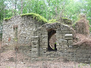
Black Heath was a house and coal mine located along the Old Buckingham Road in the present Midlothian area of Chesterfield County, Virginia. The Black Heath coal mining enterprises were operated by the Heth family between 1785 and 1844, when the mine closed following a fatal explosion.

The Clover Hill Railroad was a railroad company that operated for 36 years in central Virginia near Richmond. The railroad was created to carry coal most efficiently from the Clover Hill Pits in Winterpock, Virginia, to further transportation points in Chester, Virginia, where it could sold for a better price than on the Appomattox River in the Piedmont region. This made the railroad important to the Confederacy in the Civil War to ensure a supply of coal for munitions and iron working. The mines were dangerous for the miners, and many accidents occurred. The railroad had to be sold when coal mining declined so that new owners could find other uses for the railroad.

In 1886, Randolph Harrison, of the Virginia department of Agriculture, cited Cumberland Mining Company, stating that businessmen would soon open a hotel at Lithia Springs, Farmville, VA for people seeking the healing waters. The Brighthope railway would be extended to bring them there. But instead, the Farmville and Powhatan Railroad Company built the narrow gauge rails through Cumberland County and the Farmville and Powhatan Railroad Company bought the Brighthope Railway, so the Farmville and Powhatan Railroad made the connection. In 1890, Beach Station was built with a railroad depot, some railroad shanties, a general store and an owner's house, the George Perdue House as a stop on the line.

The Clover Hill Pits are a number of coal shafts and mines that operated in the Southside area of Richmond, Virginia from 1837 until around 1883.
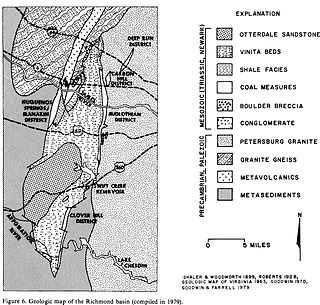
The Richmond Basin was one of the Eastern North America Rift Basins. It lies over Swift Creek Reservoir from Interstate 64 to the Appomattox River.
References
- ↑ "A History of Roads In Virginia". loudonhistory.org. Retrieved 19 July 2020.
- ↑ The Statutes At Large in Virginia, from October Session 1792, to December Session 1806. Richmond, Va.: Samuel Shepherd. 1835. pp. 374–377. Retrieved 18 July 2020.
- ↑ "A History of Roads In Virginia". loudonhistory.org. Retrieved 19 July 2020.
| This Virginia road or road transport-related article is a stub. You can help Wikipedia by expanding it. |
| This article relating to U.S. Highways is a stub. You can help Wikipedia by expanding it. |