Gallery
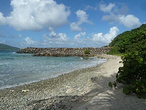 Mandahl Bay Beach
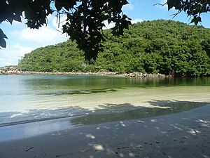 Mandahl Bay Salt Pond
 Turtle nesting site, Mandahl Bay
Mandahl or Mandal is a settlement on the Northside of the island of St. Thomas in the United States Virgin Islands.
Yvonne E. Milliner Bowsky Elementary School (formerly Peace Corps Elementary School) is located on the site of the former Mandahl Plantation factory. [1]
The Buddhist Nirvana Temple is in Mandahl. For many years, there was also a small hotel, the Inn at Mandahl. [2]
Mandahl Bay and Mandahl Salt Pond are home to a mangrove lagoon and numerous animals. [3] There is an environmental camp by the salt pond. [4]


New Kent County is a county in the eastern part the Commonwealth of Virginia. As of the 2010 United States Census, its population was 18,429. Its county seat is New Kent.
Benton County is a county located in the west central part of the U.S. state of Missouri. The population was 19,056 as of the 2010 Census. Its county seat is Warsaw. The county was organized January 3, 1835, and named for U.S. Senator Thomas Hart Benton of Missouri.

Bonaire is an island in the Leeward Antilles in the Caribbean Sea. Its capital is Kralendijk, near the ocean on the lee side of the island. Aruba, Bonaire and Curaçao form the ABC islands, 80 km off the coast of Venezuela. Unlike much of the Caribbean region, the ABC islands lie outside Hurricane Alley. The islands have an arid climate that attracts visitors seeking warm, sunny weather all year round. Bonaire is a popular snorkeling and scuba diving destination because of its multiple shore diving sites and easy access to the island's fringing reefs.

New Iberia is the largest city and parish seat of, Iberia Parish, Louisiana, United States. It is located 21 miles southeast of Lafayette.

Woods Hole is a census-designated place in the town of Falmouth in Barnstable County, Massachusetts, United States. It lies at the extreme southwest corner of Cape Cod, near Martha's Vineyard and the Elizabeth Islands. The population was 781 at the 2010 census.

North Attleborough, alternatively spelled North Attleboro, is a town in Bristol County, Massachusetts, United States. The population was 28,712 at the 2010 United States Census.

Kingsport is a city in Sullivan and Hawkins counties in the U.S. state of Tennessee; most of the city is in Sullivan County and the city is the largest in both counties, but is the county seat of neither. As of the 2010 census the population was 48,205; as of 2019 the estimated population was 54,127.

Menasha is a city in Calumet and Winnebago counties in the U.S. state of Wisconsin. The population was 17,353 at the 2010 census. Of this, 15,144 were in Winnebago County, and 2,209 were in Calumet County. The city is located mostly in Winnebago County; only a small portion is in the Town of Harrison in Calumet County. Doty Island is located partially in Menasha. The city's name comes from the Winnebago word meaning "thorn" or "island". In the Menominee language, it is known as Menāēhsaeh, meaning "little island". Menasha is home to the Barlow Planetarium and Weis Earth Science Museum, both housed at the University of Wisconsin-Fox Valley.
Weymouth is a city in Norfolk County, Massachusetts, one of 13 Massachusetts municipalities with city forms of government while retaining "town of" in their official names. It is named after Weymouth, Dorset, a coastal town in England, and is the second-oldest settlement in Massachusetts, second only to Plymouth, Massachusetts. It is one of the South Shore's more affordable towns and offers a short commute into Boston, MBTA bus and rail service, and a town beach.

Pond Inlet is a small, predominantly Inuit community in the Qikiqtaaluk Region of Nunavut, Canada, and is located in northern Baffin Island. At the 2016 census the population was 1,617, an increase of 4.4% from the 2011 census Pond Inlet was named in 1818 by explorer John Ross after John Pond, an English astronomer. The mayor is Joshua Katsak. Tununiq Sauniq Cooperative Limited, most often referred to simply as the Co-op, also operates a local hotel and other endeavours.

The Virgin Islands National Park is an American national park preserving about 60% of the land area of Saint John in the United States Virgin Islands, as well as more than 5,500 acres of adjacent ocean, and nearly all of Hassel Island, just off the Charlotte Amalie, Saint Thomas harbor.
Prince's Bay is the name of a neighborhood located on the South Shore of New York City's borough of Staten Island. Prince's Bay is bordered to the north by Huguenot, to the south by the Raritan Bay, and to the west by Pleasant Plains. The neighborhood is represented in the New York State Senate by Andrew Lanza, in the New York State Assembly by Michael Reilly, and in the New York City Council by Joe Borelli.

Riverside is a neighborhood in the city of East Providence in the U.S. state of Rhode Island. Despite not being an incorporated city, Riverside has its own zip code, 02915, and is an acceptable mailing address according to the United States Postal Service. Riverside has a population of approximately 20,000 people.

Kalihi is a neighborhood of Honolulu on the island of Oʻahu in Hawaiʻi, United States. Split by the Likelike Highway, it is flanked by downtown Honolulu to the east and Mapunapuna, Moanalua and Salt Lake to the west.

Mayreau is the smallest inhabited island of the Grenadines, with an area of about 0.46 sq. miles and a population of about 271. The population is centered in an unnamed village, located on Station Hill, a hilltop in the south-west of the island. It is an isolated community, accessible only by boat. Electricity was only recently (2002) provided by a central generator located on Saline Bay. There is a single-lane concrete road leading from the wharf on Saline Bay through the village to Saltwhistle Bay. The top of the island is crested with the small elementary school; the telecommunications building; the brick and stone Catholic Church of the Immaculate Conception, christened on May 12, 1930, and a Pentecostal church. From the crest of the hill behind the Catholic Church, there is an overlook of the Tobago Cays, Canouan and Union Island.

Warwick Parish is one of the nine parishes of Bermuda. It is named after Robert Rich, 2nd Earl of Warwick (1587-1658).

The Halifax Regional Centre for Education is the public school district responsible for 136 elementary, junior high, and high schools located in the Halifax Regional Municipality in Halifax County, Nova Scotia, Canada. The current Regional Executive Director is Elwin LeRoux. The district's office is on Spectacle Lake Drive, Dartmouth. The district's stated vision is "to provide a high quality education to every student every day". On January 24, 2018 the provincial government announced would be dissolved and education administered by an appointed provincial council and the board was dissolved on March 31, 2018.

Burin is a town on the Burin Peninsula in Placentia Bay, Newfoundland and Labrador, Canada. The Burin Peninsula is often affectionately nicknamed "The Boot" due to its resemblance to the footwear when seen on a map, with the town of Burin located near the "heel". Burin is approximately 318 km from the capital of St. John's. Settlement in Burin dates to the early 18th century, although documentary evidence indicates that French fishermen had been fishing and exploring the area even earlier.
Nestor is a residential neighborhood in the southern section of San Diego, and part of the Otay Mesa-Nestor community planning area. It neighbors Palm City and Otay Mesa West to the east, Egger Highlands to the north, San Ysidro to the southeast and the Tijuana River Valley to the south. Major thoroughfares include Coronado Avenue, Saturn Boulevard, Hollister Street, and Tocayo Avenue.
Coordinates: 18°21′20″N64°53′55″W / 18.35551°N 64.898476°W