Related Research Articles

The North Eastern Province is one of the former provinces of Kenya. It had a land area of 127,358.5 km2, with its capital at Garissa. The North Eastern Province was carved out of the then Northern Frontier District (NFD) prior to independence.
Laikipia County is one of the 47 Counties of Kenya, located on the Equator in the former Rift Valley Province of the Country. Laikipia is a cosmopolitan County and is Listed as County number 31. The county has two major urban centres: Nanyuki to the southeast, and Nyahururu to the southwest. Its County government headquarters town is Rumuruti. The County lies between latitudes 0° 18" South and 0° 51" North and between longitudes 36° 11" and 37° 24' East. It borders Samburu County to the North, Isiolo County to the North East, Meru County to the East, Nyeri County to the South East, Nyandarua County to the South, Nakuru County to the South West and Baringo County to the West.

Kericho County is one of the 47 counties in Kenya. The county seats between longitude 35°02' and 35°40' East and between the equator and latitude 0°23' South with an altitude of about 2002m above sea level. It borders Uasin Gishu County to the North West, Baringo County to the North-East, Nandi County to the North-West, Nakuru County to the East and Bomet County to the South, Kisumu County to the Northwest and Nyamira County to the West. It has a population of 901,777 and an area of 2,111 km². Its capital and largest town is Kericho.

Lamu County is a county in Kenya located along the North Coast of the country and is one of the six Coastal Counties in Kenya. Its capital is the town of Lamu. It borders Tana River County to the southwest, Garissa County to the north, Somalia to the northeast, and the Indian Ocean to the South.

Mandera is the capital of Mandera County in the former North Eastern Province of Kenya. It is situated at around 3°55′N41°50′E, near the borders with Somalia and Ethiopia.
Nyeri County is a county located in the central region of Kenya. Its capital and largest town is Nyeri. It has a population of 759,164 and an area of 2361 km2. Mutahi Kahiga was governor as of 2022. Previous governors include Nderitu Gachagua, who died while receiving treatment in London, Wamathai Samuel Githaiga, and Wahome Gakuru, who died in a road accident at Kabati near Kenol heading towards Thika Super Highway. It is also the home county of the third president of Kenya, the late President Mwai Kibaki.
Marsabit County is a county in Kenya, covering a surface area of 66,923.1 square kilometres. Marsabit is the second largest county by size in Kenya after Turkana county which has an area of 71,597.8 km2. Its capital is Marsabit and its largest town is Moyale. According to the 2019 census, the county has a population of 459,785. It is bordered to the North by Ethiopia, to the West by Turkana County to the South by Samburu County and Isiolo County, and to the East by Wajir County.

Makueni County is a county in the former Eastern Province of Kenya. Its capital town is Wote.The largest town is Wote town followed by Emali town which is also an important market and stop over for the Standard Gauge Railway (SGR). Emali town is multicultural and adds diversity to Makueni county.The county has a population of 987,653. The county lies between Latitude 1° 35' and 2° 59' South and Longitude 37° 10' and 38° 30' East. It borders Machakos County to the North, Kitui County to the East, Taita Taveta County to the South and Kajiado County to the West and covers an area of 8,008.9 km2.

Garissa County is an administrative county in Kenya. It is located in Eastern Kenya bordering Somalia to the East, Wajir County and Isiolo County to the North, Tana River County to the West and Lamu County to the South. Its capital and largest urban area is Garissa.
Mandera County is one of the counties in Kenya that has its capital and largest town as Mandera. The county is bordered by Ethiopia to the north, Somalia to the east and Wajir County to the southwest. According to the 2019 census, the county has a population of 1,200,890 and an area of 25,939.8 square kilometres (10,015.4 sq mi). The main economic activity in the county is pastoralism, while others include cross-border trade with Ethiopia, artisanal mining, beekeeping, and agriculture along the Dawa River.
Cherangany Constituency, comprises the larger Trans Nzoia East District; otherwise known as Cherangani Sub-County, with an approximate area of 556.9 square km. It is an electoral constituency in Kenya, which was established/created for the 1988 general election.
Mandera West Constituency is an electoral constituency in Kenya that was established for the 1966 elections. It is one of six constituencies in Mandera County. It has five wards, all electing councillors to the Mandera County Assembly.
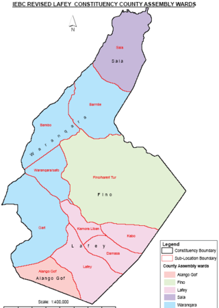
Lafey Constituency is a constituency in Mandera County, Kenya. It is one of six constituencies in the county. The town of Lafey is the capital of the constituency, and is located at around 3°55′N 41°50′E / 3.917°N 41.833°E, near the border with Somalia.

The Independent Electoral and Boundaries Commission (IEBC) is an independent regulatory agency that was founded in the year 2011 through the making of the Constitution of Kenya. The Commission is responsible for conducting or supervising referendums and elections to any elective body or office established by the Constitution, and any other elections as prescribed by an Act of Parliament. It was created in a provision of the 2010 constitution and the Independent Electoral and Boundaries Commission Act. Its mandate includes "the continuous registration of voters and revision of the voter's roll, the delimitation of constituencies and wards, the regulation of political parties process, the settlement of electoral disputes, the registration of candidates for elections, voter education, the facilitation of the observation, monitoring and evaluation of elections, the regulation of money spent by a candidate or party in respect of any election, the development of a code of conduct for candidates and parties, [and] the monitoring of compliance with legislation on nomination of candidates by parties."

Sub-counties, also known as Districts, are the decentralised units through which government of Kenya provides functions and services. At national level, sub-counties take a more administrative function like security, statistical purposes, provision of government services, etc. Even though the sub-counties are divisions of counties, powers to create new national sub-counties lies with the national government. As of 2023, there are 314 sub-counties, compared to 290 constituencies. A deputy county commissioner is appointed by the state to lead each sub-county. The sub-counties are further divided into divisions, locations and sub-locations.
Rhamu, known to the locals as "shantooley", is a town in the Mandera County of Kenya situated in the northeastern part of Kenya,along the River Dawa. The town lies within a semi-arid region characterized by dry and hot conditions, with limited rainfall and sparse vegetation. It is largely populated by the Degodia which forms majority of the Mandera north constituency settling in the wards of Ashabito,Guticha, Rhamu Dimtu,Rhamu town and Garre murule as well as a substantial settlement of somalis. The town was previously built by the british colonial administration.
Rhamu is located at the international border between Kenya and Ethiopia. Due to its proximity to Ethiopia, Rhamu has historically been a center for cross-border trade. Local traders engage in the exchange of goods, including livestock, agricultural products, and other commodities with their Ethiopian counterparts.
Lafey is a town and sub-county in the Mandera County of Kenya. It sits in the northeast part of the country, at the international border with Somalia.
Shaaban Ali Isaack is a Kenyan politician. He hails from the Murule Clan of the Jidle Hawiye clan of the Somalis
Adan Mohamed Nooru is a Kenyan politician and member of the Keyan and East African Legislative Assembly. He was first elected to the parliament from Mandera North Constituency during the one- party system in Kenya in 1983 and served as an assistant minister under the Kenya African National Union (KANU) government.
Mohamed Huka Adan was a Kenyan politician and a member of the 11th parliament of Kenya elected from Mandera South Constituency on the ticket of United Republican Party (URP) and with the support of Jubilee Coalition. In the parliament, he served on the house committee on Education, Research and Technology and spoke 63 times in the parliament during the 11th assembly. He died in March 2019 from an undisclosed illness.
References
- ↑ "Constituency – Constituencies in Kenya". softkenya. Archived from the original on July 10, 2017. Retrieved 9 June 2018.
{{cite web}}: CS1 maint: unfit URL (link) - ↑ "Constituencies". The National Government Constituencies Development Fund (NG-CDF). Retrieved 9 June 2018.
- ↑ Malalo, Humphrey; Sheikh, Abdi; Miriri, Duncan (January 3, 2018). Williams, Alison (ed.). "Al Shabaab kills five Kenyan policemen who were out on patrol". Reuters. Archived from the original on January 3, 2018.
Daniel Bundotich, the deputy county commissioner for Mandera South, said those killed included three police reservists, local civilians who usually assist the police and are assigned uniforms and arms.