Related Research Articles

The Taupō Volcanic Zone (TVZ) is a volcanic area in the North Island of New Zealand. It has been active for at least the past two million years and is still highly active.

Ruatāhuna is a small town in the remote country of Te Urewera, in the northeast of New Zealand's North Island. It is 90 kilometres directly west of Gisborne, and 18 kilometres northwest of Lake Waikaremoana. By road, it is 50 kilometres south-east of Murupara, and 110 kilometres north-west of Wairoa. It is on the upper reaches of the Whakatāne River, and surrounded on three sides by the Te Urewera protected area, formerly the Te Urewera National Park. The road that runs from Murupara through Ruatahuna to Āniwaniwa on Lake Waikaremoana, a large part of which is unsealed, used to be designated as part of State Highway 38. It is a subdivision of the Galatea-Murupara ward of the Whakatāne District.

Moturiki Island is a small island located just off Mount Maunganui beach, in the North Island of New Zealand. The island is connected to the beach by a man made land bridge. NIWA maintains a tide metre on Moturiki Island. Moturiki Island offers walking, bird watching, fishing and rock climbing opportunities.

Waiotapu is an active geothermal area at the southern end of the Okataina Volcanic Centre, just north of the Reporoa caldera, in New Zealand's Taupo Volcanic Zone. It is 27 kilometres south of Rotorua. Due to dramatic geothermal conditions beneath the earth, the area has many hot springs noted for their colourful appearance, in addition to the Lady Knox Geyser, Champagne Pool, Artist's Palette, Primrose Terrace and boiling mud pools. These can mostly be viewed through access by foot, and in addition to a paid and curated experience, naturally forming hot springs appear around the area. The geothermal area covers 18 square kilometres. Prior to European occupation the area was the homeland of the Ngāti Whaoa tribe who descended from those on the Arawa waka (canoe).
The Moerangi River or Moerangi Stream is a small river located in New Zealand's Whirinaki Te Pua-a-Tāne Conservation Park. It is one of the main tributaries of the Waiau River, Hawke's Bay. This river is mostly used by trampers (hikers), fishermen, and hunters.

Tauranga Harbour is the natural tidal harbour that surrounds Tauranga CBD and the Mount Maunganui area of Tauranga, New Zealand, and which flows into the Pacific Ocean at Mount Maunganui. The harbour is effectively two flooded river systems separated from the Pacific Ocean by Matakana Island.
The Hinemaiaia Stream is a river of the central North Island of New Zealand. It flows northwest from Kaimanawa Forest Park, flowing into the eastern shore of Lake Taupō at Hatepe, halfway between Taupō and Tūrangi. It is a popular Fly fishing stream with good numbers of Rainbow trout spawning in the winter months of June through to September.
The Horomanga River is a river of the northeastern North Island of New Zealand. The river flows north through Te Urewera National Park, reaching its confluence with the Rangitaiki River 12 kilometres (7 mi) north of Murupara. A well formed horse track follows the river valley to its headwaters. There are an abundant amount of introduced species such as Red deer, Rusa deer and wild pigs that provide hunters and locals with a supply of meat and recreation. The river itself holds good numbers of rainbow and some brown trout. There is a rebuilt 5 bed hut where midway hut used to stand. Midway hut was burnt down. the forest cover in the river valley is predominantly Tawa and podocarps from the river level to about 700–800 metres, before transitioning to predominantly Tawai (beech) forest. The mountain range on the west side of the Horomanga is steep and rugged, with thick almost impenetrable bush. Serious care should be taken when hunting or tramping on this side of the river valley. The east side of the Horomanga is a sharp contrast to the west, as the bush here is more open, and the hills less steep. However, care should be taken when hunting on this side of the river, for the lower, less defined ridgelines of this area are easy to get disorientated or lost in.
The Ōamaru River is a river of the centre of New Zealand's North Island. One of the headwaters of the Mohaka River, it flows generally northeast from its source 35 kilometres (22 mi) southeast of Tūrangi, and forms the boundary between the Kaimanawa and Kaweka Forest Parks.
The Te Hoe River is a river of the Hawke's Bay region of New Zealand's North Island. It flows south from its sources west of Lake Waikaremoana to reach the Mohaka River 20 kilometres north of Lake Tutira.

The Wairakei River or Wairakei Stream is a river of the Waikato Region of New Zealand's North Island. It flows southeast to meet the Waikato River, which it does at the town of Wairakei, 10 kilometres north of Taupō.
The Wheao River is a river of the Bay of Plenty region of New Zealand's North Island. An upper tributary of the Rangitaiki River, it flows predominantly north through the Kaingaroa Forest to reach the Rangitaiki south of Murupara.
Minginui is a town in Whakatāne District and Bay of Plenty Region on New Zealand's North Island.

Iwitahi is a rural locality in the Taupō District and Bay of Plenty Region of New Zealand's North Island. It is situated on State Highway 5 between Taupō and Napier, about 20 km southeast of Taupō. It is a farming area, largely surrounded by forest, close to the plains of the upper Rangitaiki River. The locality was formerly known as Iwatahi.

The Huka Prawn Park is an aquaculture venture and tourist attraction located 10 minutes north of Taupō. It was started in 1987, and is currently New Zealand's only prawn farm. It can produce over 30 tonnes of prawns a year.
The Otamatea River is a river of the northwestern Hawke's Bay region of New Zealand's North Island. It flows generally north from its origins in the northern foothills of the Ahimanawa Range, reaching the Rangitaiki River 25 kilometres southwest of Taupō amid the Kaingaroa Forest.
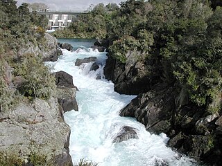
The Aratiatia Rapids are an area of New Zealand river rapids downstream from the dam for the Aratiatia Power Station on the Waikato River. The rapids are extremely dangerous.

Te Whaiti or Te Whāiti, formerly called Ahikereru, is a forested area in the Whakatāne District and Bay of Plenty Region of New Zealand's North Island. It is at the northern end of the Ahikereru valley – Minginui is at the southern end. The Whirinaki River flows through the valley.
Mihi is a rural community in Rotorua Lakes within the Waikato region of New Zealand's North Island. It is located on the northern banks of the Waikato River, near the mouth of the Waiotapu Stream, and just off State Highway 5.
Waiohau or Waiōhau is a rural valley in the Whakatāne District and Bay of Plenty region of New Zealand's North Island, north of Murupara and south of Lake Matahina.
References
- ↑ "Place name detail: Manganuiohou River". New Zealand Gazetteer. New Zealand Geographic Board . Retrieved 21 April 2010.
38°50′39″S176°54′29″E / 38.844225°S 176.908029°E