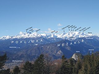
The Julian Alps are a mountain range of the Southern Limestone Alps that stretch from northeastern Italy to Slovenia, where they rise to 2,864 m at Mount Triglav, the highest peak in Slovenia. A large part of the Julian Alps is included in Triglav National Park. The second highest peak of the range, the 2,755 m high Jôf di Montasio, lies in Italy.
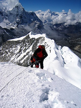
A summit is a point on a surface that is higher in elevation than all points immediately adjacent to it. The topographic terms acme, apex, peak, and zenith are synonymous.
This is a list of the extreme points of Europe: the geographical points that are higher or farther north, south, east or west than any other location in Europe. Some of these positions are open to debate, as the definition of Europe is diverse.
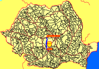
The Transfăgărășan or DN7C is a paved mountain road crossing the southern section of the Carpathian Mountains of Romania. It has national-road ranking and is the second-highest paved road in the country after the Transalpina. It starts near the village of Bascov, near Pitești, and stretches 90 kilometres (56 mi) to the crossroad between the DN1 and Sibiu, between the highest peaks in the country, Moldoveanu and Negoiu. The road, built in the early 1970s as a strategic military route, connects the historic regions of Transylvania and Wallachia.

The M41, known informally and more commonly as the Pamir Highway, is a road traversing the Pamir Mountains through Afghanistan, Uzbekistan, Tajikistan and Kyrgyzstan with a length of over 1,200 km. It is the only continuous route through the difficult terrain of the mountains and is the main supply route to Tajikistan's Gorno-Badakhshan Autonomous Region. The route has been in use for millennia, as there are a limited number of viable routes through the high Pamir Mountains. The road formed one link of the ancient Silk Road trade route. M41 is the Soviet road number, but it only remains as an official designation in post-Soviet Uzbekistan, as confirmed by official decree. Kyrgyzstan and Tajikistan have passed decrees abolishing Soviet numbering of highways and assigning their own national numbering.
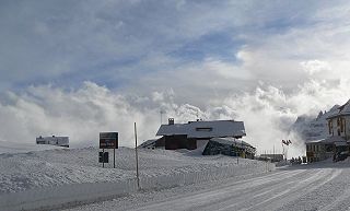
Pordoi is a pass in the Dolomites in the Alps, located between the Sella group in the north and the Marmolada group in the south. The pass is at an altitude of 2,239 m (7,346 ft), and the road crossing the pass connects Arabba with Canazei. It is the second highest surfaced road traversing a pass in the Dolomites, after the Sella Pass.

Radl Pass, with an elevation of 670 metres (2,200 ft), is a mountain pass in the Alps, located on the border between Austria and Slovenia in the Bundesland of Styria.

The Predil Pass or Predel Pass is a high mountain pass on the border between Italy and Slovenia.

Mount Jalovec is a mountain in the Julian Alps. With an elevation of 2,645 m, it is the sixth-highest peak in Slovenia. It stands between the Tamar, Koritnica, and Trenta Alpine valleys. Nearby peaks include Mangart to the west, Travnik and Mojstrovka to the east, and Ponce to the north. The Log Cliff stands immediately southwest of Mount Jalovec.

Log pod Mangartom, is a settlement in the Municipality of Bovec in the Littoral region of Slovenia. It comprises the former villages of Gorenji Log and Spodnji Log as well as the hamlets of Loška Koritnica, Možnica, and Pustina.

Mangart or Mangrt is a mountain in the Julian Alps, located on the border between Italy and Slovenia. With an elevation of 2,679 metres (8,789 ft), it is the third-highest peak in Slovenia, after Triglav and Škrlatica. It was first climbed in 1794 by the naturalist Franz von Hohenwart. Mangart is also the name of the mountain range between the Koritnica Valley and the Mangart Valley, with the highest peak called Veliki Mangart.

Cave del Predil is a frazione subdivision of the comune of Tarvisio in the Province of Udine, in the Friuli-Venezia Giulia region of northeastern Italy.
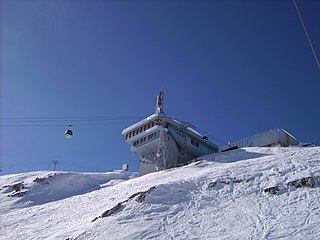
Kanin-Sella Nevea is a joint Slovenian-Italian ski resort located on the slopes of Mt Kanin and Sella Nevea Pass at the Slovenian-Italian border. The nearest locality is Bovec. On the Italian side, Tarvisio and Chiusaforte are the closest settlements.

The Stelvio Pass is a mountain pass in northern Italy bordering Switzerland at an elevation of 2,757 m (9,045 ft) above sea level. It is the highest paved mountain pass in the Eastern Alps, and the second highest in the Alps, 7 m (23 ft) below France's Col de l'Iseran.
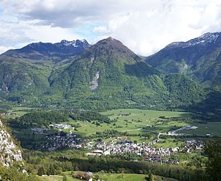
The Municipality of Bovec is a municipality in northwestern Slovenia. Its center is the town of Bovec. As of June 2016, its mayor is Valter Mlekuž.

Mangart Saddle or the Mangart Pass is a mountain saddle in the Julian Alps in northwestern Slovenia. It has an elevation of 2,072 metres (6,798 ft). It is the most common starting point for the ascent of Mt. Mangart. The Mangart Road that leads over Mangart Saddle, with its elevation of 2,055 m (6,742 ft), has a number of turns and is the highest-lying road in Slovenia. It was built in 1938. The Mangart Pass offers a picturesque view towards the Log Koritnica Valley in Slovenia to the south and the Lakes of Fusine in Italy to the north. The Mangart Saddle Lodge lies under the saddle. The saddle was the scenery of the film Let's Go Our Own Way. Mangart Saddle is also known as the finding place of manganese nodules from the Early Jurassic period.

The evolution of motorways construction in European Union member states by total number of kilometres existing in that year. This is a list of the total number of Motorways by country, member of the European Union. It includes motorways, classified as such by the Eurostat.
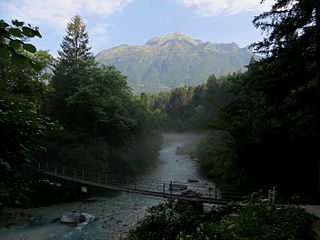
The Koritnica, with a length slightly over 16 kilometers (9.9 mi), is a right tributary of the Soča River. It flows west through the Log Koritnica Valley south of Mount Mangart and then turns south near Log pod Mangartom, flowing past the Kluže Fortress and through the 70-meter (230 ft) deep and 200-meter (660 ft) long Kluže Canyon, also known as the Koritnica Canyon. It empties into the Soča southeast of Bovec.
