
Admiral Sir James Stirling was a British naval officer and colonial administrator. His enthusiasm and persistence persuaded the British Government to establish the Swan River Colony and he became the first Governor and Commander-in-Chief of Western Australia. In 1854, when Commander-in-Chief, East Indies and China Station, Stirling on his own initiative signed Britain's first Anglo-Japanese Friendship Treaty. Throughout his career Stirling showed considerable diplomatic skill and was selected for a number of sensitive missions. Paradoxically, this was not reflected in his personal dealings with officialdom and his hopes for preferment received many rebuffs. Stirling also personally led the attack in Western Australia on a group of approximately seventy Bindjareb men, women and children now known as the Pinjarra massacre.
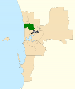
The Division of Stirling was an Australian electoral division in the inner northern and beachside suburbs of Perth, Western Australia, which included a large portion of the local government area of the City of Stirling.
Flinders Bay is a bay that is immediately south of the townsite of Augusta, and close to the mouth of the Blackwood River.
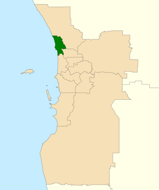
The Division of Moore is an Australian electoral division in the state of Western Australia.
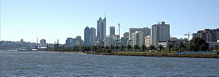
Perth Water is a section of the Swan River on the southern edge of the central business district of Perth, Western Australia. It is between the Causeway to the east, and Narrows Bridge to the west – a large wide but shallow section of river, and the northern edge of the suburb South Perth. It is considered a landmark of the City of Perth.

Hamelin Bay is a bay and a locality on the southwest coast of Western Australia between Cape Leeuwin and Cape Naturaliste. It is named after French explorer Jacques Félix Emmanuel Hamelin, who sailed through the area in about 1801. It is south of Cape Freycinet.

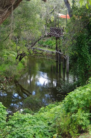
The Canning River is a major tributary of the Swan River in the South West Land Division of Western Australia. It is home to much wildlife including dolphins, pelicans, swans and many other bird species.
Preston Point is a small point in the Swan River, Western Australia. It is located in the Perth bordering the suburbs of East Fremantle and Bicton, about 12 kilometres (7.5 mi) south west of the city centre. On the other side of the river is Rocky Bay and the suburbs of North Fremantle and Mosman Park.

Point Belches is a small point on the south side of Swan River, Western Australia, about 250 metres (820 ft) east of The Narrows within the area known as Perth Water. The land is part of the South Perth Esplanade, and the water off the point is used as a commercial water skiing area.

Melville Water is a significant section of the Swan River in Perth, Western Australia. It is located west and downstream of Perth Water, from which it is separated by the Narrows Bridge.

James Drummond was an Australian botanist and naturalist who was an early settler in Western Australia.

The Murray River is a river in the southwest of Western Australia. It played a significant part in the expansion of settlement in the area south of Perth after the arrival of British settlers at the Swan River Colony in 1829. It should not be confused with the Murray River in southeastern Australia, which is the longest river in the country.
The Harvey River is a river in Western Australia and is the southernmost of the three major waterways which drain into the Peel-Harvey Estuary, with its delta in the southern extreme of the Harvey Estuary. It is about 90 km in length, rising near Mount Keats. Due to flooding of grazing land the river was diverted to discharge directly into the ocean in 1934.
The Bali Sea is the body of water north of the island of Bali and south of Kangean Island in Indonesia. The sea forms the south-west part of the Flores Sea, and the Madura Strait opens into it from the west.
Guy Fawkes River, a perennial stream that is part of the Clarence River catchment, is in the New England and Northern Tablelands districts of New South Wales, Australia.

The Donnelly River is a river in the South West of Western Australia. Its main tributaries are Barlee Brook and Carey Brook. The river runs primarily through state forest reserves, although 25 private landholdings are situated along the length of the river. Clearing of the catchment area is estimated at 20% with the land mostly being used for viticulture, horticulture, dairy, grazing and tourism.

Stirling County was one of the 26 counties of Western Australia that were designated in 1829 as cadastral divisions. It approximately corresponds to the southern part of the Hay Land District which forms the basis for land titles in the area.
Lockhart River is a river in the Wheatbelt region of Western Australia. It is a sub-catchment of the Avon River, and has an area of 32,400 square kilometres (12,500 sq mi). At its junction with the Yilgarn River to form the Salt River, it passes through a hydrological-topographical pinch-point at 'Caroline Gap'.
The Lunenburgh River is a perennial river in the South West region of Western Australia.
