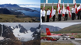
Ammassalik was one of two municipalities in Tunu, the former county of East Greenland − the other one being Illoqqortoormiut. It was located in southeastern Greenland, and with an area of 232,100 km2, most of it on the ice sheet, it was the largest municipality of East Greenland. It is now mostly part of the new Sermersooq municipality, except for the uninhabited area from Timmiarmiut southwards, which is part of the new Kujalleq municipality. The population was 3,031 on 1 January 2005. Due to its size, the old municipality bordered more municipalities than any other in Greenland (10):

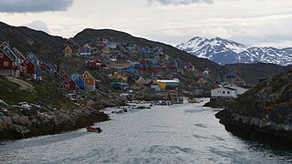
Maniitsoq, formerly Sukkertoppen, is a town in Maniitsoq Island, western Greenland located in the Qeqqata municipality. With 2,534 inhabitants as of 2020, it is the sixth-largest town in Greenland.

Kitaa, originally Vestgrønland, is a former administrative division of Greenland. It was by far the most populated of the divisions, being home to almost 90% of the total population. The divisions were de facto replaced by statistical regions after Greenland received home rule in 1979.

Kangaamiut, formerly known as Gammel Sukkertoppen, is a settlement with a population of 293 (2020) in the Qeqqata municipality in central-western Greenland.

Itilleq is a settlement in the Qeqqata municipality in central-western Greenland. It is located on a small island around 1 km from the mainland, 45 km south of Sisimiut and 2 km north of the Arctic Circle on the shores of Davis Strait. It had 89 inhabitants in 2020.

Qeqqata is a municipality in western Greenland, operational from 1 January 2009. The municipality was named after its location in the central-western part of the country. Its population is 9,378 as of January 2020. The administrative center of the municipality is in Sisimiut.

Maniitsoq Airport is an airport located on Maniitsoq Island, 0.5 NM northwest of Maniitsoq, a town in the Qeqqata municipality in central-western Greenland. It can serve STOL aircraft, although there is no deicing equipment at the airport, which is costly and problematic in Greenlandic winter.
Upernavik Archipelago is a vast coastal archipelago in the Avannaata municipality in northwestern Greenland, off the shores of northeastern Baffin Bay. The archipelago extends from the northwestern coast of Sigguup Nunaa peninsula in the south at approximately 71°50′N56°00′W to the southern end of Melville Bay in the north at approximately 74°50′N57°30′W.

Sermersuut Island is an uninhabited island in the Qeqqata municipality in western Greenland.

Simiutaq Island is a 13 km × 10 km uninhabited island in the Qeqqata municipality in western Greenland, located in the mouth of the long Kangerlussuaq Fjord. It was also known informally as Cruncher Island.
Kangerlussuatsiaq Fjord is a fjord in the Qeqqata municipality in western Greenland. Taking its source in the tidewater glaciers draining the Maniitsoq ice cap, the fjord flows in a deep canyon through a mountainous, uninhabited region, emptying into Davis Strait near the settlement of Kangaamiut.
Kangaamiut Kangerluarsuat Fjord is a fjord in the Qeqqata municipality in western Greenland. The fjord is located halfway between the lower runs of the long Kangerlussuaq Fjord in the north, and Kangerlussuatsiaq Fjord in the south, emptying into Davis Strait.
Isortoq Fjord is a fjord in the Qeqqata municipality in western Greenland. The fjord to the east of Maniitsoq, emptying into Davis Strait. Majorqaq, one of the widest rivers in western Greenland draining the Greenland ice sheet, empties into the fjord head.
Tasiusaq Bay is a bay in the Upernavik Archipelago in the Avannaata municipality in northwestern Greenland. It is an indentation of northeastern Baffin Bay. The name of the bay derives from the name of the settlement of the same name in the bay.
Upernavik Icefjord is a fjord in Avannaata municipality in northwestern Greenland.
Qassersuaq Peninsula is a mainland peninsula in northwestern Greenland, located in the south-central part of Upernavik Archipelago.
Maniitsoq is an island of Greenland. It is located in Tasiusaq Bay in the Upernavik Archipelago.

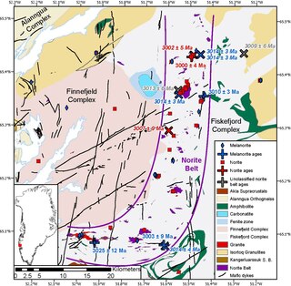
The Maniitsoq Norite Belt is a ~75 km x 15 km J-shaped belt of igneous norite intrusions, located in the Akia Terrane of the North Atlantic Craton, Greenland, near the town of Maniitsoq. The belt is found as enclaves ranging from meter-scale pods to 8 km2 large intrusive bodies within the ~3050 to 2990 Ma TTG and dioritic gneisses of the Akia terrane. and formed contemporaneously with the host gneisses between ~3013 and 3001 Ma The norites underwent high grade granulite facies metamorphism at temperatures of ~800 °C and pressures of ~9 kbar from ~3010 to 2980 Ma, soon after they were intruded. The norites were metamorphosed twice more at ~2.7 Ga and ~2.5 Ga.


