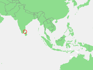
The Gulf of Mannar is a large shallow bay forming part of the Laccadive Sea in the Indian Ocean with an average depth of 5.8 m (19 ft). It lies between the southeastern tip of India and the west coast of Sri Lanka, in the Coromandel Coast region. The chain of low islands and reefs known as Adam’s Bridge or Rama Setu, which includes Mannar Island, separates the Gulf of Mannar from Palk Bay, which lies to the north between India and Sri Lanka. The estuaries of Thamirabarani River and Vaippar River of South India and the Malvathu Oya of Sri Lanka drain into the Gulf. The dugong is found here.

The Laccadive Sea, also known as the Lakshadweep Sea, is a body of water bordering India, the Maldives, and Sri Lanka. It is located to the southwest of Karnataka, to the west of Kerala and to the south of Tamil Nadu. This warm sea has a stable water temperature through the year and is rich in marine life, the Gulf of Mannar alone hosting about 3,600 species. Mangaluru, Kasaragod, Kannur, Kozhikode, Ponnani, Kochi, Alappuzha, Kollam, Thiruvananthapuram, Tuticorin, Colombo, Negombo and Malé are the major cities on the shore of the Laccadive Sea. Kanyakumari, the southernmost tip of peninsular India, also borders this sea.
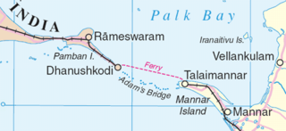
Mannar Island, formerly spelt Manar Island, which lies off the north-western coast of Sri Lanka, is part of Mannar District, Sri Lanka. It is linked to the main island of Sri Lanka by a causeway and the Mannar Bridge, which carries the A14 highway, and a railway bridge. It has an area of about 130 square kilometres (50 sq mi), mainly covered with vegetation and sand.
Kankesanthurai, colloquially known as KKS, is a port suburb, fishing division and resort hub of the Jaffna District, Northern Province, Sri Lanka. Formerly an electoral district, Kankesanthurai is home to the Kankesanthurai beach, Keerimalai Naguleswaram temple and the Maviddapuram Kandaswamy Temple. The port's harbour has served as an arrival and departure point for pilgrims since classical antiquity and is named after the Sri Lankan Tamil god Murukan. Kankesanthurai suburb has many fishing villages and Grama Niladhari and is a northern part of Valikamam, one of the three regions of ancient habitation on the Jaffna peninsula, located on the peninsula's northern coast, 12 miles from Jaffna city, 85 miles from Mannar and 155 miles from Trincomalee.
Mannar may refer to the following places:

The Shrine of Our Lady of Madhu is a Roman Catholic Marian shrine in Mannar district of Sri Lanka. With a history of more than 400 years, the shrine acts as a center of pilgrimage and worship for Sri Lankan Catholics. The site is considered as the holiest Catholic shrine in the island and is a well known place of devotion for both Tamil and Sinhalese Catholics. The church has been a symbol of unity not just between Tamils and Sinhalese but also between people of different religions, including Buddhists, Hindus and Protestants.

Talaimannar is a settlement in Sri Lanka located on the northwestern coast of Mannar Island.
The Portuguese conquest of the Jaffna kingdom occurred after Portuguese traders arrived at the rival Kotte kingdom in the southwest of modern Sri Lanka in 1505. Many kings of Jaffna, such as Cankili I, initially confronted the Portuguese in their attempts at converting the locals to Roman Catholicism, but eventually made peace with them.

Mannar is the main town of Mannar District, Northern Province, Sri Lanka. It is governed by an Urban Council. The town is located on Mannar Island overlooking the Gulf of Mannar and is home to the historic Ketheeswaram temple. In the Tamil language, Mannar means the raised place [of sand] which is thought to have come from the geology of Mannar Island which was formed by the accumulation of sand.
Mannar Electoral District was an electoral district of Sri Lanka between August 1947 and February 1989. The district was named after the town of Mannar in Mannar District, Northern Province. The 1978 Constitution of Sri Lanka introduced the proportional representation electoral system for electing members of Parliament. The existing 160 mainly single-member electoral districts were replaced with 22 multi-member electoral districts. Mannar electoral district was replaced by the Vanni multi-member electoral district at the 1989 general elections, the first under the PR system, though Mannar continues to be a polling division of the multi-member electoral district.

Mannar District is one of the 25 districts of Sri Lanka, the second level administrative division of the country. The district is administered by a District Secretariat headed by a District Secretary appointed by the central government of Sri Lanka. The capital of the district is Mannar, which is located on Mannar Island.
The Mannar line is a railway line in Sri Lanka. Branching off the northern line at Medawachchiya Junction, the line heads north-west through North Central and Northern provinces before terminating at the town of Talaimannar. The line is 106 kilometres (66 mi) long and has 11 stations. The line opened in 1914.
Bishop Rayappu Joseph was a Sri Lanka Tamil prelate and the Roman Catholic Bishop of Mannar.
Madhu Road railway station is a railway station in the town of Madhu in northern Sri Lanka. The station serves pilgrims visiting the Shrine of Our Lady of Madhu. Owned by Sri Lanka Railways, the state-owned railway operator, the station is part of the Mannar Line which links Mannar Island with the capital Colombo. The station was not functioning between 1990 and 2013 due to the civil war. The Mannar Line between Medawachchiya and Madhu Road was re-opened on 14 May 2013.

The Round Island Lighthouse is an offshore lighthouse on Round Island in Trincomalee Bay, Sri Lanka and is operated and maintained by the Sri Lanka Ports Authority. The lighthouse was erected in 1863, originally it was a red light however in 1864 it was changed to white.

Kovalam Point Lighthouse is a lighthouse on the island of Karaitivu in northern Sri Lanka. Built in 1916, the 30 metres (98 ft) white lighthouse has a round masonry tower. The light itself is 31 metres (102 ft) above sea level. An observer on a ship 30.48 metres (100.0 ft) tall can see this light from 21.4 nautical miles
Mannar Island Lighthouse is a lighthouse in Talaimannar on Mannar Island in northern Sri Lanka. Built in 1915, the 19 metres (62 ft) white lighthouse has a round cylindrical tower with lantern and gallery.
Mannar Fort is located on Mannar Island, Sri Lanka. It was built by Portuguese in 1560 and christened São Jorge. The fort fell to the Dutch in 1658, and they rebuilt the fort in 1696. In 1795 the British occupied the fort following the surrender by the Dutch.

The Thambapavani Wind Farm named after Thambapanni and Pavan meaning wing in Sinhalese. Also called Mannar Island Wind Farm or Mannar Wind Farm) is a 100-megawatt wind farm which was built on the southern coast of the Mannar Island, in Sri Lanka. The project would cost approximately US$200 million, 78% of which will be borne by the Asian Development Bank, while the remaining 22% will be borne by the developers, the Ceylon Electricity Board. Identification of land plots and ownership has already begun. It is currently regarded as the largest wind farm in Sri Lanka and it is also the first wind power plant to be owned by the Ceylon Electricity Board.
Manar, sometimes Al Manar, may refer to:
