Mannlgrat

Last updated
The Mannlgrat ridge runs from lower right towards the upper left this side of the Hoher Goll's summit HoherGoell.jpg
The Mannlgrat ridge runs from lower right towards the upper left this side of the Hoher Göll's summit

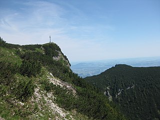
The Mannlgrat is an east-facing ridge on the Hoher Göll in the Bavarian Alps rising above Obersalzberg near Berchtesgaden.

Hoher Göll mountain

The Hoher Göll is a 2,522 m (8,274 ft) mountain in the Berchtesgaden Alps, the highest peak of the Göll massif, which straddles the border between the German state of Bavaria and Salzburg, Austria.

Bavarian Alps part of the Alps mountain range in Bavaria, Germany

Bavarian Alps is a summarizing term of several mountain ranges of the Northern Limestone Alps in the German state of Bavaria.

Obersalzberg mountain

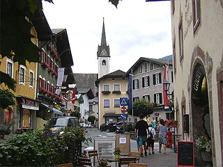
Obersalzberg is a mountainside retreat situated above the market town of Berchtesgaden in Bavaria, Germany. Located about 120 kilometres (75 mi) southeast of Munich, close to the border with Austria, it is best known as the site of Adolf Hitler's former mountain residence, the Berghof, and of the mountaintop Kehlsteinhaus, popularly known in the English-speaking world as the "Eagle's Nest." All of the Nazi buildings were demolished in the 1950s but the relevant past of the area is the subject of the Dokumentationszentrum Obersalzberg museum which opened in 1999.

The ridge rises from a col separating it from a subpeak of the Hoher Göll, the Kehlstein , upon which the famous Kehlsteinhaus is located. Served by a Klettersteig, the Mannlgrat is regarded as the easiest route to the Hoher Göll's summit. [1]

Mountain pass Route through a mountain range or over a ridge

A mountain pass is a navigable route through a mountain range or over a ridge. Since many of the world's mountain ranges have presented formidable barriers to travel, passes have played a key role in trade, war, and both human and animal migration throughout Earth's history. At lower elevations it may be called a hill pass. The highest vehicle-accessible pass in the world appears to be Mana Pass, located in the Himalayas on the border between India and Tibet, China.

Kehlstein mountain

The Kehlstein is, at an elevation of 1,881 metres (6,171 ft), a subpeak of the Göll massif, a 2,522-metre-high (8,274 ft) mountain in the Berchtesgaden Alps. The rocky promontory is located west of the Hoher Göll main summit, high above the Obersalzberg mountain retreat near Berchtesgaden. It is chiefly known for the Kehlsteinhaus mountain inn built in 1937–1938, which is a major tourist destination.

Kehlsteinhaus architectural structure

The Kehlsteinhaus is a Third Reich-era building erected atop the summit of the Kehlstein, a rocky outcrop that rises above the Obersalzberg near the town of Berchtesgaden. It was used exclusively by members of the Nazi Party for government and social meetings. It was visited on 14 documented instances by Adolf Hitler, who disliked the location due to his fear of heights, the risk of bad weather, and the thin mountain air. Today it is open seasonally as a restaurant, beer garden, and tourist site.

Related Research Articles

Hallein District District in Salzburg, Austria

The Bezirk Hallein is an administrative district (Bezirk) in the federal state of Salzburg, Austria, and congruent with the Tennengau region.

Ibei HaNahal is an Israeli outpost within the Gush Etzion settlement block in the West Bank. Its residents established it as an ecovillage. The outpost is under the jurisdiction of the Gush Etzion Regional Council. The international community considers Israeli settlements in the West Bank illegal under international law, but the Israeli government disputes this.

Schönau am Königsee Place in Bavaria, Germany

Schönau am Königssee is a municipality in the district of Berchtesgadener Land in the German state of Bavaria. It is located at the northern end of the Königssee lake.

Golling an der Salzach Place in Salzburg, Austria

Golling an der Salzach is a market town in the Hallein district of Salzburg, Austria.

Dokumentationszentrum Obersalzberg Museum in Obersalzberg

Dokumentation Obersalzberg is a museum in the Obersalzberg resort near Berchtesgaden, providing historical information on the use of the mountainside retreat by Nazi leaders, especially Hitler who regularly vacationed in this area beginning in 1928. The museum was opened in 1999, and by 2007 had been visited by more than one million people.

Hoher Mechtin mountain

At a height of 142 m above sea level (NN) the Hoher Mechtin is the highest elevation in the Wendland in the district of Lüchow-Dannenberg in northern Germany, and is at the same time a significant high point on the entire North German Plain. It lies roughly at the centre point of the Drawehn ridge, which is also described as the East Hanoverian gravel or end moraine.. The area is part of the Ostheide division of the Lüneburg Heath.

Burg Golling castle in the state of Salzburg, Austria

Burg Golling is a castle in Golling an der Salzach, in the Austrian state of Salzburg, erected by the Prince-Archbishops of Salzburg in the 13th century. The large fortress is located on a rock above the Salzach valley near the strategically important narrows between the Hagen and Tennen Mountains, at 469 metres (1,539 ft) above sea level.

Satsuma-Matsumoto Station railway station in Kagoshima, Kagoshima prefecture, Japan

Satsuma-Matsumoto Station is a railway station on the Kagoshima Main Line operated by Kyushu Railway Company in Kagoshima, Kagoshima, Japan.

Ahornbüchsenkopf mountain

The Ahornbüchsenkopf is a northern subpeak of the Hoher Göll, 1,604 m above sea level (NN) high, in the Berchtesgaden Alps in the county of Berchtesgadener Land, Bavaria, Germany, and the state of Salzburg in Austria.

Jenner (mountain) Mountain in Bavaria, Germany

The Jenner is a mountain in Bavaria, Germany. It is part of the Göll massif within the Berchtesgaden Alps. Its summit, accessible from Schönau by cable car (Jennerbahn) since 1953, offers panoramic views to the Watzmann range and the Königssee below.

Karkopf mountain

The Karkopf is a mountain, 1,738 m, and the highest peak of the whole Lattengebirge range in the German state of Bavaria. It lies exactly on the boundary between the municipality of Bayerisch Gmain to the west and the municipality of Bischofswiesen to the east.

The Hoher Kranzberg is a mountain in Bavaria, Germany.

Hoher Stein (Fichtelgebirge)

The Hoher Stein is a rock formation at the northeastern foot of the Bergkopf mountain, part of the Waldstein ridge in the Germany's Fichtel Mountains.

Ketyan is a Syrian village located in Taftanaz Nahiyah in Idlib District, Idlib. According to the Syria Central Bureau of Statistics (CBS), Ketyan had a population of 1876 in the 2004 census.

High Vogelsberg Nature Park nature park in Hesse, Germany

The High Vogelsberg Nature Park lies in the highlands of the Vogelsberg in the centre of the German state of Hesse. It covers the region of eleven rings around Oberwald, the central part of the mountain range, certain municipalities in the counties of Vogelsbergkreis, Wetteraukreis, Gießen and Main-Kinzig-Kreis. The park has an area of 883.36 km² and is thus roughly as large as the capital city of Berlin.

Hoher Burgstall (Kalkkögel) mountain in Austria

The Hoher Burgstall is a mountain, 2,611 m, in the Kalkkögel in the Stubai Alps, southeast of the Schlicker Seespitze. Its summit offers a good view into the Oberbergtal, the upper Stubaital, the Serles ridge and the Kalkkögeln.

The Fulda-Werra Uplands are a major natural regional unit in the East Hesse Highlands in East and North Hesse and, with small elements in the southeast, in the German state of Thuringia. Most of the range lies right of the River Fulda and left of the Werra. The uplands extend from the Rhön mountains northwards, to the River Weser near Hann. Münden.

References

  1. http://www.summitpost.org/mannlgrat/156788

Coordinates: 47°36′19″N13°03′14″E / 47.6053°N 13.0539°E / 47.6053; 13.0539

Geographic coordinate system Coordinate system

A geographic coordinate system is a coordinate system that enables every location on Earth to be specified by a set of numbers, letters or symbols. The coordinates are often chosen such that one of the numbers represents a vertical position and two or three of the numbers represent a horizontal position; alternatively, a geographic position may be expressed in a combined three-dimensional Cartesian vector. A common choice of coordinates is latitude, longitude and elevation. To specify a location on a plane requires a map projection.