
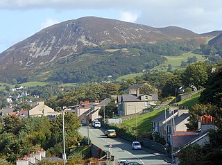
Blaenau Ffestiniog is a town in Gwynedd, Wales. Once a slate mining centre in historic Merionethshire, it now relies much on tourists, drawn for instance to the Ffestiniog Railway and Llechwedd Slate Caverns. It reached a population of 12,000 at the peak development of the slate industry, but fell with the decline in demand for slate. The population of the community, including the nearby village Llan Ffestiniog, was 4,875 at the 2011 census: the fourth most populous in Gwynedd after Bangor, Caernarfon and Llandeiniolen. The population not including Llan is now only about 4,000.
Penmaenmawr is a town and community in Conwy County Borough, Wales, which was formerly in the parish of Dwygyfylchi and the traditional county of Caernarfonshire. It is on the North Wales coast between Conwy and Llanfairfechan and was an important quarrying town, though quarrying is no longer a major employer. The population of the community was 4,353 in 2011, including Dwygyfylchi and Capelulo. The town itself having a population of 2,868 (2011).

Tanygrisiau is a village and area within Blaenau Ffestiniog in the upper end of the Vale of Ffestiniog in the county of Gwynedd, north-west Wales. It can be found along the southern side of the Moelwyn mountain range and dates to around 1750. It joins onto the semi-urban area of Blaenau Ffestiniog, and is in the community of Ffestiniog; located between 650 feet (200 m) and 750 feet (230 m) above sea level. it is in the electoral ward of Bowydd and Rhiw which had a 2011 census population of 1878. The village itself has a population of around 350.

The River Dwyryd, is a river in Gwynedd, Wales which flows principally westwards; draining to the sea into Tremadog Bay, south of Porthmadog.
The Croesor Tramway was a Welsh, 2 ft narrow gauge railway line built to carry slate from the Croesor slate mines to Porthmadog. It was built in 1864 without an Act of Parliament and was operated using horse power.

Moelwyn Mawr is a mountain in Snowdonia, North Wales and forms part of the Moelwynion. Its summit overlooks the Vale of Ffestiniog and has views in all directions.

Craigysgafn is a rocky ridge and a top of Moelwyn Mawr that leads south from Moelwyn Mawr to Moelwyn Bach in Snowdonia, North Wales. It has several gullies which lead directly down to the scree slopes above Llyn Stwlan. Some scrambling is needed in places.

Manod Mawr is a mountain in North Wales and forms part of the Moelwynion. Although known as a mountain in the eastern Moelwyns, it and its sister peaks are sometimes known as the Ffestiniog hills.

The Moelwynion are a group of mountains in central Snowdonia, north Wales. They extend from the north-east of Porthmadog to Moel Siabod, the highest of the group. The name derives from the names of two of the largest mountains in the group, Moelwyn Mawr and Moelwyn Bach, 770m and 710m, respectively. Moel Siabod, to the north, is the highest at 872m.

Moel Penamnen is a mountain just north of Blaenau Ffestiniog, North Wales and forms part of the Moelwynion.

The Rhiwbach Tramway was a Welsh industrial, 1 ft 11+1⁄2 in narrow gauge railway connecting the remote slate quarries east of Blaenau Ffestiniog with the Ffestiniog Railway. It was in use by 1862, and remained so until progressively closed between 1956 and 1976. The route included three inclines, one of which became the last operational gravity incline in the North Wales slate industry. The tramway was worked by horses and gravity for much of its existence, but a diesel locomotive was used to haul wagons on the top section between 1953 and its closure in 1961.

Tan-y-Manod railway station was a railway station approximately 1 mile (1.6 km) south of Blaenau Ffestiniog, in Gwynedd, North Wales.

Moelwyn Mawr North Ridge Top is a top of Moelwyn Mawr in Snowdonia, North Wales and forms part of the Moelwynion. From its summit, which directly overlooks Bwlch Rhosydd, can be seen Cnicht, Allt-fawr and Moel-yr-hydd. A recently discovered 'top' has only received attention from Nuttall baggers.

Y Ro Wen is a mountain just north of Blaenau Ffestiniog, North Wales and forms part of the Moelwynion.

Y Gamallt is a mountain located in the Migneint in Snowdonia, North Wales. It forms part of the Arenig mountain range being separated from the Moelwynion range at the head of Cwm Teigl.

Graig Ddu quarry is a disused slate quarry near Blaenau Ffestiniog, in Gwynedd, North Wales. Although output was only about 3,000 tons a year, it reputedly has 36 saw tables and the same number of dressing machines on site. As with others in the area, the quarry suffered from a lack of water, resulting in the siting of the mill some distance away, at a lower level.

Moelwyn quarry is a defunct slate quarry located to the south of the village of Tanygrisiau, north Wales. Some initial prospecting was carried out in the 1820s and again in the 1840s, but it was 1860 before a company was formed, and chambers were excavated. The quarry was never a financial success, and operated sporadically until its demise in 1897. Despite the poor results, a spectacular series of seven inclines were constructed, to enable slates to reach the Ffestiniog Railway. The quarry was hampered by lack of a good water supply, and the mill was constructed between inclines 4 and 5, where water could be obtained from Llyn Stwlan. As in many quarries, barracks were provided, but these were occupied by whole families, living on the mountain, rather than used as lodgings for the quarrymen during the working week. Even in its remote location, there was still a concern for education, with basic literacy classes being run in the 1860s.
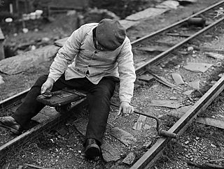
The car gwyllt is a Welsh invention used by quarrymen to ride downhill on the steep inclined planes of a slate quarry.
Mawr is a community in south Wales.

Bwlch y Slaters quarry is a slate quarry near Blaenau Ffestiniog, in Gwynedd, North Wales.
