Mansfield Road, Oxford

Last updated

Mansfield College on Mansfield Road. Mansfield College Oxford 20040124.jpg
Mansfield College on Mansfield Road.
Harris Manchester College on Mansfield Road. HarrisManchesterDusk.jpg
Harris Manchester College on Mansfield Road.
Building work at the southern end of Mansfield Road. White vans Oxford.JPG
Building work at the southern end of Mansfield Road.
Oxford map small.svg
Blue pog.svg
Location of Mansfield Road within central Oxford

Mansfield Road is a road in central Oxford, England. [1] [2] It runs north-south with two of Oxford University's colleges on it, Mansfield College and Harris Manchester College, and Queen Elizabeth House which houses the Oxford Department of International Development.

To the north is South Parks Road and the University's main Science Area. To the south is Holywell Street. Also off this road to the east near its southern end is Jowett Walk, named after Benjamin Jowett, a Master of Balliol College in Victorian times. On the northern corner with Jowett Walk is the former Geography Department of the University, since 2006 the Oxford Department of International Development (No. 3 Mansfield Road).

Savile Road is a cul-de-sac to the west with New College School (associated with New College in Holywell Street close by) just to the north. The University Club sports ground, for use by graduate students and University staff, is based on Mansfield Road, and hosts a football team named after the road, Mansfield Road Football Club, [3] playing in the Morrells of Oxford Premier League, and the Mansfield Road Cricket Club, or Oxford University Club Cricket Club (OUCCC). [4]

The Oxford University Club Hurriers (OUCH) were formerly known as the Mansfield Road Runners. [5]

Halifax House, a social club for people associated with Oxford University, was located to the east of the northern end of Mansfield Road at 8 South Parks Road from 1961. [6] The building has since been demolished to make way for new university science facilities. Evidence of Bronze Age barrows together with later prehistoric and early Roman field systems was found on the site. [7]

Mansfield Road Club

The Mansfield Road Club was established in 1960 by Jack Cox and Rupert Cecil as a successor to the informal staff club which first met in the old Zoology Department in the Oxford University Museum of Natural History, and which later moved to a basement room in Keble Road.[ citation needed ] Jack Cox joined the Biochemistry Department in 1926 at the age of 15, and retired after 50 years' service in 1976. He was responsible for designing attachments for the Svedberg ultracentrifuge and other specialized equipment, and in 1978 he was awarded an MA for services to Oxford University. A twenty-over cricket competition, the Jack Cox Cup, is now played each year in recognition of his contribution to the Club.

Related Research Articles

<span class="mw-page-title-main">Oxford</span> City and district in Oxfordshire, England

Oxford is a cathedral city and non-metropolitan district in Oxfordshire, England, of which it is the county town. Founded in the 8th century, it was granted city status in 1542. The city is located at the confluence of the rivers Thames and Cherwell. It had a population of 163,257 in 2022. It is 56 miles (90 km) north-west of London, 64 miles (103 km) south-east of Birmingham and 61 miles (98 km) north-east of Bristol. The city is home to the University of Oxford, the oldest university in the English-speaking world; it has buildings in every style of English architecture since late Anglo-Saxon. Oxford's industries include motor manufacturing, education, publishing, science, and information technologies.

<span class="mw-page-title-main">Balliol College, Oxford</span> College of the University of Oxford

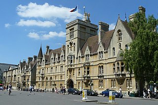
Balliol College is a constituent college of the University of Oxford. Founded in 1263 by nobleman John I de Balliol, it has a claim to be the oldest college in Oxford and the English-speaking world.

<span class="mw-page-title-main">University Parks</span> Parkland area northeast of the city centre in Oxford, England

The Oxford University Parks, commonly referred to locally as the University Parks, or just The Parks, is a large parkland area slightly northeast of the city centre in Oxford, England. The park is bounded to the east by the River Cherwell, though a small plot of land called Mesopotamia sits between the upper and lower levels of the river. To the north of the parks are Norham Gardens and Lady Margaret Hall, to the west the Parks Road, and the Science Area on South Parks Road to the south. The park is open to the public during the day, and has gardens, large sports fields, and exotic plants. It includes a cricket ground used by Oxford University Cricket Club.

<span class="mw-page-title-main">Broad Street, Oxford</span> Street in central Oxford, England

Broad Street is a wide street in central Oxford, England, just north of the former city wall. The street is known for its bookshops, including the original Blackwell's bookshop at number 50, located here due to the University of Oxford. Among residents, the street is traditionally known as The Broad. On the street is a memorial paving for the Oxford Martyrs.

<span class="mw-page-title-main">South Parks Road</span> Road in Oxford, England

South Parks Road is a road in Oxford, England. It runs east–west past the main Science Area of the University of Oxford. Many of the university science departments are located nearby or face the road, including parts of the geography, zoology, chemistry, psychology and physiology departments. Also on the road is Rhodes House.

<span class="mw-page-title-main">Parks Road</span> Road in Oxford, England

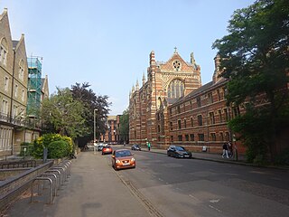
Parks Road is a road in Oxford, England, with several Oxford University colleges along its route. It runs north–south from the Banbury Road and Norham Gardens at the northern end, where it continues into Bradmore Road, to the junction with Broad Street, Holywell Street and Catte Street to the south.

<span class="mw-page-title-main">Holywell Street, Oxford</span> Street in central Oxford, England

Holywell Street is a street in central Oxford, England. It runs east–west with Broad Street to the west and Longwall Street to the east. About halfway along, Mansfield Road adjoins to the north.

<span class="mw-page-title-main">St Cross Road</span> Road in Oxford, England

St Cross Road is a road in Oxford, England. It links South Parks Road to the north and Longwall Street to the south, where it also meets Holywell Street. The road is named after St Cross Church.

<span class="mw-page-title-main">Keble Road</span> Road in central Oxford, England

Keble Road is a short road running east–west in central Oxford, England. To the west is the southern end of the Banbury Road with St Giles' Church opposite. To the east is Parks Road with the University Parks opposite. Blackhall Road leads off the road to the south near the western end.

<span class="mw-page-title-main">Canterbury Road</span> Road in North Oxford, England

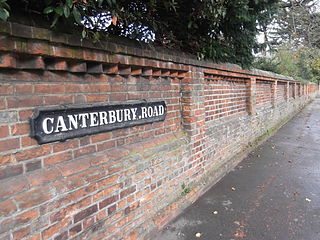
Canterbury Road is a road in North Oxford, England. It runs between Woodstock Road to the west and Banbury Road to the east. Winchester Road leads south from halfway along Canterbury Road, linking with Bevington Road that runs parallel to the south. Also to the south are North Parade and Church Walk.

<span class="mw-page-title-main">Alfred Street</span> Street in central Oxford, England

Alfred Street is a street running between the High Street to the north and the junction with Blue Boar Street and Bear Lane at the southern end, in central Oxford, England. To the south is Christ Church, one of Oxford University's historic colleges.

<span class="mw-page-title-main">Catte Street</span> Street in central Oxford, England

Catte Street is a historic street in central Oxford, England.

<span class="mw-page-title-main">Holywell Manor, Oxford</span> Historic building in central Oxford, England

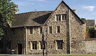
Holywell Manor is a historic building in central Oxford, England, in the parish of Holywell. It currently houses some of Balliol College's postgraduate student population. It is on the corner of Manor Road and St Cross Road, next to St Cross Church, which has become the Balliol College Historic Collections Centre.

<span class="mw-page-title-main">Jowett Walk</span> Road in central Oxford, England

Jowett Walk is a road in central Oxford, England. It connects Mansfield Road to the west with St Cross Road to the east, running parallel with and north of Holywell Street.

<span class="mw-page-title-main">St Cross Church, Oxford</span> Church in Oxford, United Kingdom

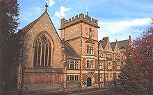
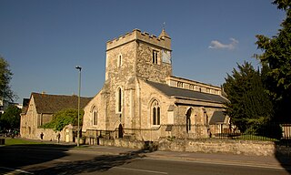
St Cross Church is a former parish church, now a historic collections centre, in Oxford, England, to the northeast of the centre of the city. The church is on St Cross Road at the junction with Manor Road, just south of Holywell Manor. Also close by is Holywell Cemetery.

<span class="mw-page-title-main">Norham Road</span> Road in North Oxford, England

Norham Road is a road which lies east of the Banbury Road in central North Oxford, a suburb in the city of Oxford, England.

<span class="mw-page-title-main">Rawlinson Road</span>

Rawlinson Road is a residential road in North Oxford, England.

<span class="mw-page-title-main">Crick Road</span> Road in North Oxford, England

Crick Road is a road in North Oxford, England, an area characterised by large Victorian Gothic villas.

<span class="mw-page-title-main">Manor Road, Oxford</span> Road in central Oxford, England

Manor Road is a road in central Oxford, England. It is a no through road that links St Cross Road to the west with St Catherine's College, one of the newer Oxford colleges, to the east. The road crosses the Holywell Mill Stream.

<span class="mw-page-title-main">Holywell Music Room</span> Chamber music hall in Oxford, England

The Holywell Music Room is the city of Oxford's chamber music hall, situated on Holywell Street in the city centre, and is part of Wadham College. Built in 1748, it is said to be the oldest purpose-built music room in Europe, and hence Britain's first concert hall.

References

  1. Sherwood, Jennifer; Pevsner, Nikolaus (1974). The Buildings of England: Oxfordshire. Penguin Books. pp. 233, 234, 274, 330. ISBN   0-14-071045-0.
  2. Tyack, Geoffrey (1998). Oxford: An architectural guide. Oxford University Press. pp. 272, 342. ISBN   0-14-071045-0.
  3. Mansfield Road Football Club, University of Oxford, UK.
  4. Oxford University Club Cricket Club (OUCCC) Archived 2008-09-30 at the Wayback Machine , University of Oxford, UK.
  5. Oxford University Club Hurriers (OUCH, formerly Mansfield Road Runners), University of Oxford, UK.
  6. "Halifax House" (PDF). oua.ox.ac.uk. University of Oxford, UK. Retrieved 15 June 2011.
  7. Anthony, Sian (2005). "Prehistoric and Early Roman Field Systems, Halifax House, South Parks Road, Oxford" (PDF). Oxoniensia . 70: 129–139.

51°45′26″N1°15′07″W / 51.7572°N 1.2520°W / 51.7572; -1.2520