
A geographic information system (GIS) consists of integrated computer hardware and software that store, manage, analyze, edit, output, and visualize geographic data. Much of this often happens within a spatial database, however, this is not essential to meet the definition of a GIS. In a broader sense, one may consider such a system also to include human users and support staff, procedures and workflows, the body of knowledge of relevant concepts and methods, and institutional organizations.

The Brundtland Commission, formerly the World Commission on Environment and Development, was a sub-organization of the United Nations (UN) that aimed to unite countries in pursuit of sustainable development. It was founded in 1983 when Javier Pérez de Cuéllar, the Secretary-General of the United Nations, appointed Gro Harlem Brundtland, former Prime Minister of Norway, as chairperson of the commission. Brundtland was chosen due to her strong background in the sciences and public health.

Sir Peter Geoffrey Hall was an English town planner, urbanist and geographer. He was the Bartlett Professor of Planning and Regeneration at The Bartlett, University College London and president of both the Town and Country Planning Association and the Regional Studies Association. Hall was one of the most prolific and influential urbanists of the twentieth century.
The Royal Town Planning Institute (RTPI) is the professional body representing planners in the United Kingdom, and Ireland. It promotes and develops policy affecting planning and the built environment. Founded in 1914, the institute was granted a royal charter in 1959. In 2018 it reported that it had over 25,000 members.
Private sector development (PSD) is a term in the international development industry to refer to a range of strategies for promoting economic growth and reducing poverty in developing countries by building private enterprises. This could be through working with firms directly, with membership organisations to represent them, or through a range of areas of policy and regulation to promote functioning, competitive markets.
Social innovations are new social practices that aim to meet social needs in a better way than the existing solutions, resulting from - for example - working conditions, education, community development or health. These ideas are created with the goal of extending and strengthening civil society. Social innovation includes the social processes of innovation, such as open source methods and techniques and also the innovations which have a social purpose—like activism, virtual volunteering, microcredit, or distance learning. There are many definitions of social innovation, however, they usually include the broad criteria about social objectives, social interaction between actors or actor diversity, social outputs, and innovativeness. Different definitions include different combinations and different number of these criteria. Transformative social innovation not only introduces new approaches to seemingly intractable problems, but is successful in changing the social institutions that created the problem in the first place.
A local development framework is the spatial planning strategy introduced in England and Wales by the Planning and Compulsory Purchase Act 2004 and given detail in Planning Policy Statements 12. In most parts of the two countries, maintaining the framework is the responsibility of English district councils and Welsh principal area councils.
Participatory GIS (PGIS) or public participation geographic information system (PPGIS) is a participatory approach to spatial planning and spatial information and communications management.
Interreg is a series of programmes to stimulate cooperation between regions in and out of the European Union (EU), funded by the European Regional Development Fund. The first Interreg started in 1989. Interreg IV covered the period 2007–2013. Interreg V (2014–2020) covers all 27 EU member states, the EFTA countries, six accession countries and 18 neighbouring countries. It has a budget of EUR 10.1 billion, which represents 2.8% of the total of the European Cohesion Policy budget. Since the non EU countries don't pay EU membership fee, they contribute directly to Interreg, not through ERDF.
Patsy Healey is a British urban planner. She is professor emeritus at Global Urban Research Unit in the School of Architecture, Planning & Landscape, at Newcastle University. She is a specialist in planning theory and practice, with a particular focus on strategic spatial planning for city regions and in urban regeneration policies. She is Senior Editor of Planning Theory and Practice journal, jointly published by TandF and the RTPI.
Sustainable procurement is a process whereby organizations meet their needs for goods, services, works and utilities in a way that achieves value for money on a life-cycle basis while addressing equity principles for sustainable development, therefore benefiting societies and the environment across time and geographies. Procurement is often conducted via a tendering or competitive bidding process. The process is used to ensure the buyer receives goods, services or works for the best possible price, when aspects such as quality, quantity, time, and location are compared. Procurement is considered sustainable when organizations broadens this framework by meeting their needs for goods, services, works, and utilities in a way that achieves value for money and promotes positive outcomes not only for the organization itself but for the economy, environment, and society. This framework is also known as the triple bottom line, which is a business accounting framework. The concept of TBL is narrowly prescribed, and even John Elkington, who coined the term in the 1990s, now advocates its recall. Indeed, procurement practitioners have drawn attention to the fact that buying from smaller firms, locally, is an important aspect of sustainable procurement in the public sector. Ethics, culture, safety, diversity, inclusion, justice, human rights and the environment are additionally listed as important aspects of SPP.
Town and country planning in Wales is based on the land use planning system which applies in England. However, the system in Wales has some distinctive features which have arisen because substantial responsibility for town and country planning has been devolved to the Welsh Government (WAG). In particular, Wales now has a Spatial Plan and Welsh Ministers have a duty to under the Government of Wales Act 2006 to promote sustainable development.
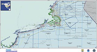
Marine spatial planning (MSP) is a process that brings together multiple users of the ocean – including energy, industry, government, conservation and recreation – to make informed and coordinated decisions about how to use marine resources sustainably. MSP generally uses maps to create a more comprehensive picture of a marine area – identifying where and how an ocean area is being used and what natural resources and habitat exist. It is similar to land-use planning, but for marine waters.

The Afghanistan Research and Evaluation Unit (AREU) is an independent research organization based in Kabul, Afghanistan. It aims to provide a firm basis for policy and practice in the country's rapidly changing environment by conducting in-depth, on-the-ground research. Funding is provided by a variety of governments and agencies.

National Council for Teacher Education (NCTE) is a statutory body of Indian government set-up under the National Council for Teacher Education Act, 1993 in 1995 is to formally oversee standards, procedures and processes in the Indian education system. This council functions for the central as well as state governments on all matter with regard to the Teacher Education and its secretariat is located in the Department of Teacher Education and National Council of Educational Research and Training (NCERT). Despite the successful functioning in terms of educational field, it is facing difficulties in ensuring the maintenance of the standards of teacher education and preventing the increase in the number of substandard teacher education institutions in the country.
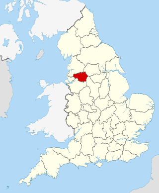
The Greater Manchester Combined Authority (GMCA) is a combined authority for Greater Manchester, England. It was established on 1 April 2011 and consists of 11 members; 10 indirectly elected members, each a directly elected councillor from one of the ten metropolitan boroughs that comprise Greater Manchester, together with the directly elected Mayor of Greater Manchester. The authority derives most of its powers from the Local Government Act 2000 and Local Democracy, Economic Development and Construction Act 2009, and replaced a range of single-purpose joint boards and quangos to provide a formal administrative authority for Greater Manchester for the first time since the abolition of Greater Manchester County Council in 1986.
The International Society of City and Regional Planners (ISOCARP) is a non-governmental global association of professional city and regional planners. It was founded in 1965 in a bid to bring together recognised and highly qualified spatial planners in an international network. The first president of ISOCARP was its co-founder Prof. Sam van Embden (1965-1975).
Water Point Mapping (WPM) is a tool for monitoring the distribution and status of water supplies. It collects data about different aspects related to the water facility and overlays this point data with information about population and administrative boundaries. WPM helps to visualize the spatial distribution of water supply coverage and can thereby be used to highlight equity issues. The information collected provides insights into schemes' sustainability levels and management-related aspects of water points.

Matthew Carmona is an architect, planner and researcher based in the United Kingdom. His research focuses on the process of design governance and management of Public Space. He has taught at the University of Nottingham and The Bartlett, the latter since 1998.

Wei Yang FAcSS FRTPI MCIHT is a Chinese-British town planner and urban designer, an author and a scholar. She is the founder of Wei Yang & Partners in London. She is a lead figure in researching, promoting and implementing the 21st Century Garden City approach and promoting joined up thinking between different built and nature environment professionals.