
The Persian Gulf, sometimes called the Arabian Gulf, is a mediterranean sea in West Asia. The body of water is an extension of the Indian Ocean located between Iran and the Arabian Peninsula. It is connected to the Gulf of Oman in the east by the Strait of Hormuz. The Shatt al-Arab river delta forms the northwest shoreline.

Gilan province is one of the 31 provinces of Iran, in the northwest of the country. Its capital is the city of Rasht. The province lies along the Caspian Sea, in Iran's Region 3, west of the province of Mazandaran, east of the province of Ardabil, and north of the provinces of Zanjan and Qazvin. It borders Azerbaijan in the north.

Merv, also known as the Merve Oasis, was a major Iranian city in Central Asia, on the historical Silk Road, near today's Mary, Turkmenistan. Human settlements on the site of Merv existed from the 3rd millennium BC until the 18th century AD. It changed hands repeatedly throughout history. Under the Achaemenid Empire, it was the center of the satrapy of Margiana. It was subsequently ruled by Hellenistic Kings, Parthians, Sasanians, Arabs, Ghaznavids, Seljuqs, Khwarazmians and Timurids, among others.

Balkh is a town in the Balkh Province of Afghanistan. It is located approximately 20 kilometres (12 mi) to the northwest of the provincial capital city Mazar-i-Sharif and approximately 74 kilometres (46 mi) to the south of the Amu Darya and the Afghanistan–Uzbekistan border. In 2021–2022, the National Statistics and Information Authority reported that the town had 138,594 residents. Listed as the eighth largest settlement in the country, unofficial 2024 estimates set its population at around 114,883 people.

Khorasan, also called Traxiane during Hellenistic and Parthian times, was a province in northeastern Iran until September 2004, when it was divided into three new provinces: North Khorasan, South Khorasan, and Razavi Khorasan.
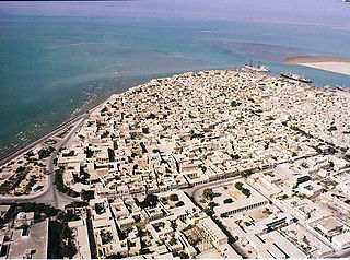
Bushehr province is one of the 31 provinces of Iran. It is in the south of the country, with a long coastline on the Persian Gulf. Its capital is the city of Bushehr.

Fars (Pars) province is one of the 31 provinces of Iran. Its capital is the city of Shiraz.

Kerman province is the largest of the 31 provinces of Iran. Its capital is the city of Kerman.

Qazvin province is one of the 31 provinces of Iran. It is in the northwest of the country, with the city of Qazvin as its capital.

Balkh is one of the 34 provinces of Afghanistan, located in the north of the country. It is divided into 15 districts and has a population of about 1,509,183, which is multi-ethnic and mostly a Persian-speaking society. The city of Mazar-i-Sharif is the capital and largest city of the province. The Mawlana Jalaluddin Mohammad Balkhi International Airport and Camp Marmal sit on the eastern edge of Mazar-i-Sharif.

Bandar Abbas is a city in the Central District of Bandar Abbas County, Hormozgan province, Iran, serving as capital of the province, the county, and the district. Bandar Abbas is a port on the southern coast of the country, on the Persian Gulf.

Shirvan is a historical region in the eastern Caucasus, as known in both pre-Islamic Sasanian and Islamic times. Today, the region is an industrially and agriculturally developed part of the Republic of Azerbaijan that stretches between the western shores of the Caspian Sea and the Kura River, centered on the Shirvan Plain.

North Khorasan province is one of the 31 provinces of Iran, located in the northeast of the country. Its capital is the city of Bojnord.

South Khorasan province is one of the 31 provinces of Iran, located in the eastern part of the country. Its capital is the city of Birjand. In 2014, the province was placed in Region 5.

Greater Khorasan is a historical eastern region in the Iranian Plateau in West and Central Asia that encompasses western and northern Afghanistan, northeastern Iran, the eastern halves of Turkmenistan and Uzbekistan, western Tajikistan, and portions of Kyrgyzstan and Kazakhstan.
The military history of Iran has been relatively well-documented, with thousands of years' worth of recorded history. Largely credited to its historically unchanged geographical and geopolitical condition, the modern-day Islamic Republic of Iran has had a long and checkered military culture and history; ranging from triumphant and unchallenged ancient military supremacy, affording effective superpower status for its time; to a series of near-catastrophic defeats, most notably including the ancient Greek kingdom of Macedon as well as the Asiatic nomadic tribes at the northeastern boundary of the lands traditionally home to the Iranian peoples.
Turkmen Sahra is a region in the northeast of Iran near the Caspian Sea, bordering Turkmenistan, the majority of whose inhabitants are ethnic Turkmen. The most important cities of Turkmen Sahra are Gonbad-e Kavus, Aqqala, Kalaleh, Maraveh Tappeh, Gomishan and Bandar Torkaman. There are, according to Ethnologue, roughly 719,000 Turkmens in Turkmen Sahra today.
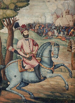
Emperor Nader Shah, the Shah of Iran (1736–1747) and the founder of the Afsharid dynasty, invaded Northern India, eventually attacking Delhi in March 1739. His army had easily defeated the Mughals at the Battle of Karnal and would eventually capture the Mughal capital in the aftermath of the battle.
Iran sustained maritime forces during Afsharid dynasty that were revived in 1734 by Nader Shah, with peak of its activity lasting more than a decade until Division of the Afsharid Empire. It operated in the Caspian Sea, where it was considered a threat by the Russian Empire. Headquartered in Bushehr, the southern flotilla maintained presence in the Persian Gulf as well as the Sea of Oman, effectively pushing against maritime Arabian empires in Sultanate of Muscat and Imamate of Oman, Pirates based in coasts that were later called Trucial, and also local rebels and mutineers. The Afsharid navy also ordered several vessels from both the British and Dutch East India Company.

The Guarded Domains of Iran, commonly referred to as Afsharid Iran or the Afsharid Empire, was an Iranian empire established by the Turkoman Afshar tribe in Iran's north-eastern province of Khorasan, establishing the Afsharid dynasty that would rule over Iran during the mid-eighteenth century. The dynasty's founder, Nader Shah, was a successful military commander who deposed the last member of the Safavid dynasty in 1736, and proclaimed himself Shah.


