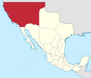
Alta California, also known as Nueva California among other names, was a province of New Spain formally established in 1804. Along with the Baja California peninsula, it had previously comprised the province of Las Californias, but was made a separate province in 1804. Following the Mexican War of Independence, it became a territory of Mexico in April 1822 and was renamed Alta California in 1824.
San Fernando is a general-law city in the San Fernando Valley region of Los Angeles County, California, in the Los Angeles metropolitan area. It is an enclave in the City of Los Angeles. As of the 2020 census the population of San Fernando was 23,946.

Chatsworth is a suburban neighborhood in Los Angeles, California, in the San Fernando Valley.

North Hills, known previously as Sepulveda, is a neighborhood in the San Fernando Valley region of Los Angeles, California.

Vasquez Rocks Natural Area Park is a 932-acre (377-hectare) park located in the Sierra Pelona in northern Los Angeles County, California. It is known for its rock formations, the result of sedimentary layering and later seismic uplift. It is located near the town of Agua Dulce, between the cities of Santa Clarita and Palmdale. The area is visible from the Antelope Valley Freeway. Its location approximately 25 miles (40 km) from downtown Los Angeles places it within Hollywood's "studio zone" and makes it a popular filming location for films and television programs.

Newhall is the southernmost and oldest community in the city of Santa Clarita, California. Prior to the 1987 consolidation of Canyon Country, Saugus, Newhall, and Valencia into the city of Santa Clarita, it was an unincorporated area. It was the first permanent town in the Santa Clarita Valley.

The Serrano are an Indigenous people of California. Their autonyms are Taaqtam meaning "people", Maarrênga’yam meaning "people from Morongo", and Yuhaaviatam meaning "people of the pines."

The Tataviam are a Native American group in Southern California. The ancestral land of the Tataviam people includes northwest present-day Los Angeles County and southern Ventura County, primarily in the upper basin of the Santa Clara River, the Santa Susana Mountains, and the Sierra Pelona Mountains. They are distinct from the Kitanemuk and the Gabrielino-Tongva peoples.

Elizabeth Lake is a natural sag pond that lies directly on the San Andreas Fault in the northern Sierra Pelona Mountains, in northwestern Los Angeles County, southern California.

Mission Indians was a term used to refer to the Indigenous peoples of California who lived or grew up in the Spanish mission system in California. Today the term is used to refer to their descendants and to specific, contemporary tribal nations in California.
Bell Canyon Park is a large open-space regional park located in the Simi Hills at the western end of the San Fernando Valley in West Hills, Los Angeles and Bell Canyon, California. Bell Creek, a primary tributary to the Los Angeles River, flows through the park with riparian zone vegetation along its natural banks. The geographic landmark Escorpión Peak is high above it to the south in adjacent El Escorpión Park.
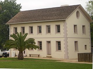
Los Encinos State Historic Park is a state park unit of California, preserving buildings of Rancho Los Encinos. The park is located near the corner of Balboa and Ventura Boulevards in Encino, California, in the San Fernando Valley. The rancho includes the original nine-room de la Ossa Adobe, the two-story limestone Garnier building, a blacksmith shop, a natural spring, and a pond. The 4.7-acre (1.9 ha) site was established as a California state park in 1949.

Cahuenga ( or "place of the hill" is a former Tongva–Tataviam Native American settlement in the San Fernando Valley of Los Angeles, Los Angeles County, California. One source suggests kawe means mountain in Tongva language. Recent linguistic work suggests an alternative meaning of "place of the fox". The Tongva-language suffix -nga indicates place, and the suffix -bet or -bit indicates person from place; people from Cahuenga were recorded in mission registers as Capuebet.
Quapa is a former Tongva village located in Encino or the San Fernando Valley in Los Angeles County, California. It was one of several villages located within the San Fernando Valley area, including Kowanga, Mapipinga, Okowvinja, Pascegna, Saway-yanga, Tacuenga, and Tuyunga.
Satwiwa was a former Chumash village in the Santa Monica Mountains of Newbury Park, California. The current Satwiwa Native American Indian Culture Center is operated by the National Park Service in cooperation with the Friends of Satwiwa. Satwiwa has been inhabited by Chumash Indians for over 10,000 years. It is situated at the foothills of Boney Mountain, a sacred mountain for the Chumash.

Achooykomenga is a former settlement that was located at the site of Mission San Fernando Rey de España before it was founded in 1797. Prior to the mission's founding, in the 1780s, it functioned as a shared native settlement for an agricultural rancho of Pueblo de Los Ángeles that was worked by Ventureño Chumash, Fernandeño (Tongva), and Tataviam laborers.
Tochonanga was a Tataviam village now located at the area of what is now Newhall, Santa Clarita, California, along the Santa Clara River.
Chaguayanga was a Tataviam village located at what is now Santa Clarita, California, around the Newhall, Valencia, and Castaic areas. Its original site was located approximately fifteen miles north and slightly west of the San Fernando Mission in the eastern areas of the San Fernando Valley. Mixed Chumash and Tataviam populations may have resided at the village.
Tsivung was a Vanyume or Serrano village located in what is now known as Antelope Valley near Elizabeth Lake, California.

Encino Hot Springs are historic thermal springs located at the site of Siutcanga village, a settlement of the Tongva-Kizh people of the area now known as Southern California. It was used by several tribes of Indigenous peoples for thousands of years. Later, after settlement, the artesian springs were used as a water source for Rancho Los Encinos in what is now the San Fernando Valley region of Los Angeles County, California. In the 1880s it was a rest stop on the Butterfield Stagecoach route. The springs are located in the modern-day Los Encinos State Historic Park.
