External links
- Company website on April 1, 2005
| | This software article is a stub. You can help Wikipedia by expanding it. |
Mapopolis Navigator was a PDA/smartphone GPS navigation software created by Mapopolis. Mapopolis used data from Navteq. [1] Mapopolis Navigator files use a proprietary format and make it impossible for users to export their custom POIs. [2] [3]
Starting in 1999, Mapopolis first released software for the Palm OS and later added software for Pocket PC handhelds and Windows smartphones. Mapopolis created the first real-time traffic service (Mapopolis ClearRoute), providing real-time route updates based on traffic conditions. [4] [5]
By April 1, 2007, Mapopolis had discontinued sales of its consumer software. [6] Map downloads remained available for at least one year past that date for registered users who purchased the product and still did not use up their full 1-year allowance.
| | This software article is a stub. You can help Wikipedia by expanding it. |
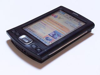
A personal digital assistant (PDA), also known as a handheld PC, is a multi-purpose mobile device which functions as a personal information manager. PDAs have been mostly displaced by the widespread adoption of highly capable smartphones, in particular those based on iOS and Android, and thus saw a rapid decline in use after 2007.

Traffic Message Channel (TMC) is a technology for delivering traffic and travel information to motor vehicle drivers. It is digitally coded using the ALERT C or TPEG protocol into Radio Data System (RDS) carried via conventional FM radio broadcasts. It can also be transmitted on Digital Audio Broadcasting or satellite radio. TMC allows silent delivery of dynamic information suitable for reproduction or display in the user's language without interrupting audio broadcast services. Both public and commercial services are operational in many countries. When data is integrated directly into a navigation system, traffic information can be used in the system's route calculation.
Computer operating systems based on the Linux kernel are used in embedded systems such as consumer electronics, in-vehicle infotainment (IVI), networking equipment, machine control, industrial automation, navigation equipment, spacecraft flight software, and medical instruments in general.

The IBM Simon Personal Communicator is a handheld, touchscreen PDA designed by International Business Machines (IBM), and manufactured by Mitsubishi Electric. Although the term "smartphone" was not coined until 1995, because of Simon's features and capabilities, it has been retrospectively referred to as the first true smartphone.

Since the Global Positioning System (GPS) was introduced in the late 1980s there have been many attempts to integrate it into a navigation-assistance system for blind and visually impaired people.
TomTom N.V. is a Dutch multinational developer and creator of location technology and consumer electronics. Founded in 1991 and headquartered in Amsterdam, TomTom released its first generation of satellite navigation devices to market in 2004. As of 2019 the company has over 4,500 employees worldwide and operations in 29 countries throughout Europe, Asia-Pacific, and the Americas.
Traffic reporting is the near real-time distribution of information about road conditions such as traffic congestion, detours, and traffic collisions. The reports help drivers anticipate and avoid traffic problems. Traffic reports, especially in cities, may also report on major delays to mass transit that does not necessarily involve roads. In addition to periodic broadcast reports, traffic information can be transmitted to GPS units, smartphones, and personal computers.

The HTC TyTN is an Internet-enabled Windows Mobile Pocket PC PDA designed and marketed by High Tech Computer Corporation of Taiwan. It has a touchscreen with a left-side slide-out QWERTY keyboard. The TyTN's functions include those of a camera phone and a portable media player in addition to text messaging and multimedia messaging. It also offers Internet services such as e-mail, instant messaging, web browsing, and local Wi-Fi connectivity. It is a quad-band GSM phone with GPRS, and EDGE, and a single/dual band UMTS phone with HSDPA. It is a part of the first line of PDAs directly marketed and sold by HTC. On AT&T/Cingular, the TyTN was the successor to the HTC Wizard, known as the Cingular 8125. Also on AT&T, the TyTN was superseded by the HTC TyTN II, known as the AT&T 8925 and the AT&T Tilt.
ViaMichelin, a wholly-owned subsidiary of the Michelin Group, is a travel website that allows road users in Europe to design and plan upcoming trips.

The HTC TyTN II is an Internet-enabled Windows Mobile Pocket PC smartphone designed and marketed by HTC Corporation of Taiwan. It has a tilting touchscreen with a right-side slide-out QWERTY keyboard. The TyTN II's functions include those of a camera phone and a portable media player in addition to text messaging and multimedia messaging. It also offers Internet services including e-mail, instant messaging, web browsing, and local Wi-Fi connectivity. It is a quad-band GSM phone with GPRS, EDGE, UMTS, HSDPA, and HSUPA.

The iGO Navigation Engine, developed by Hungary-based NNG LLC is a GPS navigation software package. NNG sells some versions of the software directly to users, as well as to device manufacturers, auto makers, network operators and professional transport specialists. Products based on iGO are available in brands including Becker, Clarion, Pioneer, Samsung and Vodafone.

The HTC Titan is a Windows Mobile 6.1 Pocket PC PDA and phone manufactured by High Tech Computer Corporation of Taiwan. It is the successor to the HTC Apache upon which it improves by adding more ROM, GPS, EVDO Rev. A, additional hard keys, a scroll-wheel, spring-loaded keyboard, and a higher resolution camera. The Windows Mobile 6.1 operating system includes Office Mobile along with HTML email through Microsoft Outlook Mobile. Windows Media Player is included, allowing the Titan to act as a digital audio and digital movie player.

A Personal Navigation Assistant (PNA) also known as Personal Navigation Device or Portable Navigation Device (PND) is a portable electronic product which combines a positioning capability and navigation functions.

A satellite navigation device, satnav device or satellite navigation receiver is a user equipment that uses one or more of several global navigation satellite systems (GNSS) to calculate the device's geographical position and provide navigational advice. Depending on the software used, the satnav device may display the position on a map, as geographic coordinates, or may offer routing directions.

Computer cartography is the art, science, and technology of making and using maps with a computer. This technology represents a paradigm shift in how maps are produced, but is still fundamentally a subset of traditional cartography. The primary function of this technology is to produce maps, including creation of accurate representations of a particular area such as, detailing major road arteries and other points of interest for navigation, and in the creation of thematic maps. Computer cartography is one of the main functions of geographic information systems (GIS), however, GIS is not necessary to facilitate computer cartography and has functions beyond just making maps. The first peer-reviewed publications on using computers to help in the cartographic process predate the introduction of full GIS by several years.
Waze Mobile Ltd, doing business as Waze, formerly FreeMap Israel, is a subsidiary company of Google that provides satellite navigation software on smartphones and other computers that support the Global Positioning System (GPS). In addition to turn-by-turn navigation, it incorporates user-submitted travel times and route details while downloading location-dependent information over a cellular network. Waze describes its application as a community-driven initiative that is free to download and use.
Sygic is a Slovak company of global automotive navigation systems for mobile phones and tablets. The company was founded in 2004 and is headquartered in Bratislava, Slovakia. It became the first company to offer navigation for iPhone and second for Android. In 2015 Sygic reached milestone of 100 million downloads of its navigation app.

TeleType Co., Inc. is a privately held company in the United States, specialized in developing software for GPS devices. It was founded in 1981, under the name TeleTypesetting Company and it is based in Boston, Massachusetts. The company's product line includes automotive and commercial GPS navigation systems and other products including GPS receivers and tracking units. It develops and sells the WorldNav software for PC and Windows CE, tools for converting third party maps into WorldNav maps, an SDK and an API that allow the customization of the WorldNav application. TeleType Co. also offers consultancy services for those interested in acquiring and adapting the source code of their software products.
Telenav, Inc. is a wireless location-based services corporation that provides services including Global Positioning System (GPS) satellite navigation, local search, automotive navigation solutions, mobile advertising, enterprise mobility and workflow automation. The company’s headquarters are located in Santa Clara, California in the United States with additional offices in the U.S., Germany, Japan, Romania, China, and Brazil.
Car apps are a genre of software that offer a car and its driver abilities above what is built-in to the vehicle. Examples of Third-party software for cars include allowing data input while moving, traffic jam assistance, diagnostics and lane-keeping.