
The North Island, also officially named Te Ika-a-Māui, is one of the two main islands of New Zealand, separated from the larger but less populous South Island by Cook Strait. With an area of 113,729 km2 (43,911 sq mi), it is the world's 14th-largest island, constituting 43% of New Zealand's land area. It has a population of 3,997,300, which is 77% of New Zealand's residents, making it the most populous island in Polynesia and the 28th-most-populous island in the world.

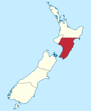
Hawke's Bay is a region on the east coast of New Zealand's North Island. The region is named for Hawke Bay, which was named in honour of Edward Hawke. The region's main centres are the cities of Napier and Hastings, while the more rural parts of the region are served by the towns of Waipukurau, Waipawa, and Wairoa.
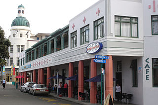
Napier is a city on the eastern coast of the North Island of New Zealand and the seat of the Hawke's Bay region. It is a beachside city with a seaport, known for its sunny climate, esplanade lined with Norfolk pines, and extensive Art Deco architecture. Napier is sometimes referred to as the "Nice of the Pacific", although that is largely outdated and a more common nickname is 'The Art Deco Capital of the world'.

Hastings is an inland city of New Zealand and is one of the two major urban areas in Hawke's Bay, on the east coast of the North Island. The population of Hastings is 51,500, with a further 15,200 people in Havelock North and 2,090 in Clive. Hastings is about 18 kilometres inland of the coastal city of Napier. These two neighbouring cities are often called "The Bay Cities" or "The Twin Cities".

Hawke Bay, formerly named Hawke's Bay, is a large bay on the east coast of the North Island of New Zealand, surrounded by the Hawke's Bay region. It stretches from Māhia Peninsula in the northeast to Cape Kidnappers / Te Kauwae-a-Māui in the southwest, a distance of some 90 kilometres (56 mi).

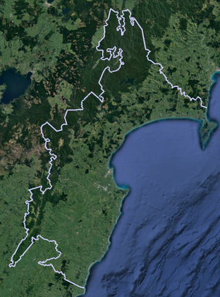
The provinces of the Colony of New Zealand existed as a form of sub-national government. Initially established in 1846 when New Zealand was a Crown colony without responsible government, two provinces were first created. Each province had its own legislative council and governor. With the passing of the New Zealand Constitution Act 1852 the provinces were recreated around the six planned settlements or "colonies". By 1873 the number of provinces had increased to nine, but they had become less isolated from each other and demands for centralised government arose. In 1875 the New Zealand Parliament decided to abolish the provincial governments, and they came to an end in November 1876. They were superseded by counties, which were later replaced by territorial authorities.
Wellington Province, governed by the Wellington Provincial Council, was one of the provinces of New Zealand from 1853 until the abolition of provincial government in 1876. It covered much of the southern half of the North Island until November 1858, when Hawke's Bay Province split off, taking about a third of its area.

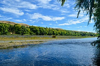
The Tukituki River is in the Hawke's Bay region of the eastern North Island of New Zealand. It flows from the Ruahine Ranges to the Pacific Ocean at the southern end of Hawke Bay.
The Tutaekuri River flows eastward for 99.9 kilometres through the Hawke's Bay Region of the eastern North Island of New Zealand into the Pacific Ocean. It starts in the Kaweka Range roughly 50 kilometres north-east of Taihape, and reaches the sea just to the south of Napier, where the Ngaruroro and Clive Rivers join it.

State Highway 2 runs north–south through eastern parts of the North Island of New Zealand from the outskirts of Auckland to Wellington. It runs through Tauranga, Gisborne, Napier, Hastings and Masterton. It is the second-longest highway in the North Island, after State Highway 1, which runs the length of both of the country's main islands.
Lake Poukawa is a small shallow hardwater lake in the Hawke's Bay Region, North Island, New Zealand. It is located about 20 km south-west of Hastings, New Zealand, close to the settlement of Te Hauke. It is the largest lake lying within a peatland in the active tectonic Poukawa depression, between the Raukawa Range and Kaokaoroa Range of central Hawke's Bay. Its maximal depth is less than one metre and its diameter is ca. 1.5 km. It was deeper in the past but it was artificially drained after the 1931 Hawke's Bay earthquake. Lake Poukawa is drained by the Poukawa Stream, which flows north-eastward through the Pekapeka Wetland and eventually into the Clive River.
Waiapu was a New Zealand parliamentary electorate in the Gisborne – East Coast Region of New Zealand, from 1893 to 1908.
The Esk River of Hawke's Bay, in the eastern North Island of New Zealand, one of two rivers of that name in the country, is one of Hawke's Bay's major rivers. It flows south from the slopes of Taraponui in the Maungaharuru Range before turning east to reach Hawke Bay 10 kilometres (6 mi) north of Napier. State Highway 5 follows the lower course of the river for several kilometres close to the settlement of Eskdale. The river is probably named after the Esk River in southern Scotland and north-west England.
Wairarapa and Hawke's Bay is a former parliamentary electorate in the Wellington region of New Zealand from 1853 to 1859, when it was extended into previously unincorporated territories, split in two, and replaced by the County of Hawke, with its southern portion being the newly created Wairarapa electorate. It is the first general electorate to have been abolished in New Zealand.
Kaweka Forest Park is in the Hawke's Bay region of New Zealand, adjacent to Kaimanawa Forest Park. This region of the central North Island contains large tracts of pine plantations, some of them also within the park, and as a consequence, invasive wilding conifers are present throughout the 594 km2 (229 sq mi) park.

The Mangaone River is a river of the Hawke's Bay region of New Zealand's North Island. Its source is numerous streams draining the slopes of the Te Waka Range in the Rukumoana Forest area. The river flows southeast then south through rugged hill country until it meets the Tutaekuri River. For most of its course it is deeply incised in the tephra, ignimbrite and lapilli volcanic rocks, which are a bit over 30,000 years old. The deep valleys are partly due to the soft rocks and partly to the rapid rise of the Mohaka Fault, at over 3 mm (0.12 in) a year.
The Whirinaki River is a river of the Hawke's Bay and Bay of Plenty Regions of New Zealand's North Island. It flows generally north through the Whirinaki Te Pua-a-Tāne Conservation Park and Kaingaroa Forest to reach the Rangitaiki River 3 kilometres (2 mi) north of Murupara.

Te Awanga is a small rural beachside town in Hawke's Bay, New Zealand. Te Awanga is near Cape Kidnappers, which has a renowned colony of the Australasian gannet.

Ahuriri Lagoon was a large tidal lagoon at Napier, on the east coast of New Zealand's North Island, that largely drained when the area was raised by the 1931 Hawke's Bay earthquake.
Te Angiangi Marine Reserve is a marine reserve covering a marine area of 446 hectares in the Hawke's Bay Region of New Zealand's North Island. It was established in 1997 and is administered by the Department of Conservation.
