
The demography of Kenya is monitored by the Kenyan National Bureau of Statistics. Kenya is a multi-ethnic state in East Africa. Its total population was at 47 558,296 as of the 2019 census.

The Maasai are a Nilotic ethnic group inhabiting northern, central and southern Kenya and northern Tanzania. They are among the best known local populations internationally due to their residence near the many game parks of the African Great Lakes, and their distinctive customs and dress. The Maasai speak the Maa language, a member of the Nilotic language family that is related to the Dinka, Kalenjin and Nuer languages. Except for some elders living in rural areas, most Maasai people speak the official languages of Kenya and Tanzania, Swahili and English. The Maasai population has been reported as numbering 1,189,522 in Kenya in the 2019 census, compared to 377,089 in the 1989 census, though many Maasai view the census as government meddling and therefore either refuse to participate or actively provide false information. Many Maasai tribes throughout Tanzania and Kenya welcome visitors to their villages to experience their culture, traditions, and lifestyle, in return for a fee.
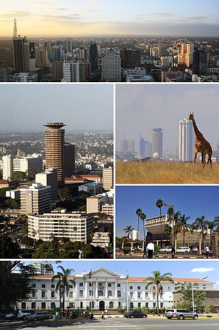
Nairobi is the capital and largest city of Kenya. The name is derived from the Maasai phrase Enkare Nairobi, which translates to "place of cool waters", a reference to the Nairobi River which flows through the city. The city proper had a population of 4,397,073 in the 2019 census, while the metropolitan area has a projected population in 2022 of 10.8 million. The city is commonly referred to as the Green City in the Sun.

Kenya, officially the Republic of Kenya, is a country in East Africa. At 580,367 square kilometres (224,081 sq mi), Kenya is the world's 48th largest country by area. With a population of more than 47.6 million in the 2019 census, Kenya is the 29th most populous country in the world. Kenya's capital and largest city is Nairobi, while its oldest, currently second largest city, and first capital is the coastal city of Mombasa. Kisumu City is the third-largest city and also an inland port on Lake Victoria. Other important urban centres include Nakuru and Eldoret. As of 2020, Kenya is the third-largest economy in sub-Saharan Africa after Nigeria and South Africa. Kenya is bordered by South Sudan to the northwest, Ethiopia to the north, Somalia to the east, Uganda to the west, Tanzania to the south, and the Indian Ocean to the southeast. Its geography, climate and population vary widely, ranging from cold snow-capped mountaintops with vast surrounding forests, wildlife and fertile agricultural regions to temperate climates in western and rift valley counties and dry less fertile arid and semi-arid areas and absolute deserts.

Samburu County is a county in the former Rift Valley Province, Kenya. It covers an area of roughly 21,000 km2 (8,000 mi2) in northern Kenya where the Samburu, Turkana and many other tribes live. It stretches north from the Wuaso Ng'iro River to the south of Lake Turkana. According to the 2019 census, the county has a population of 310,327.

Murang'a County is one of the counties of Kenya's former Central Province. Its largest town and capital is Murang'a, formerly referred to as Fort Hall during the colonial era. It is inhabited mainly by and is considered the home of the Gikuyu, the largest ethnic group in Kenya. The county has a population of 1,056,640 based on the 2019 census.

Busia is a county in the former Western Province of Kenya. It borders Kakamega County to the east, Bungoma County to the north, Lake Victoria and Siaya County to the south and Busia District, Uganda to the west. The county has about 893,000 people and spans about 1,700 square kilometers making it one of the smallest counties in Kenya. Busia is inhabited by the Luhya tribe of Kenya and the Teso of Kenya, and small groups of the Luo. The Luhya communities include the Abakhayo, Marachi, Samia and Abanyala communities.

Lamu County is a county of Kenya located along the North Coast of the country and is one of the six Coastal Counties in Kenya. Its capital is the town of Lamu. It borders Tana River County to the southwest, Garissa County to the north, Somalia to the northeast and the Indian Ocean to the South.

Tana River County is a county in the former Coast Province of Kenya. It is named after the Tana River, the longest river in Kenya. It has an area of 38,437 km2 (14,841 sq mi) and a population of 315,943 as of the 2019 census. The county borders Kitui County to the west, Garissa County to the northeast, Isiolo County to the north, Lamu County to the southeast and Kilifi County to the south. The capital and largest town is Hola.

Ruiru is a municipality and sub-county in Kiambu County. It sits within the greater Nairobi Metropolitan region. According to the 2019 national population census, Ruiru is the 6th largest urban center in Kenya by population. The name Ruiru is of the Kikuyu dialect and possibly relates to the black cotton soil that is found in most parts of Ruiru to the East and South.

Kiambu County is a county in the former Central Province of Kenya. Its capital is Kiambu and its largest town is Thika. Kiambu County is the second most populous after Nairobi County. Kiambu County borders Nairobi and Kajiado Counties to the South, Machakos to the East, Murang'a to the North and North East, Nyandarua to the North West, and Nakuru to the West and has a population of 2,417,735.
Kilifi County was formed in 2010 as a result of a merger of Kilifi District and Malindi District, Kenya. Its capital is Kilifi and its largest town is Malindi. Kilifi county is one of the five counties that harbor the Kenyan Coast with 109km 2 being in the Indian Ocean. The county has a population of 1,453,787 people following the 2019 census which covers an area of 12,245.90 km2 (4,728.17 sq mi).

Taita–Taveta County previously known as Taita Taveta District is a county of Kenya. It lies approximately 140 km northwest of Mombasa and 380 km southeast of Nairobi. Taita Taveta County is located approximately 360 km southeast of Nairobi and 200 km northwest of Mombasa, and is a port and major gateway to the United Republic of Tanzania through Taveta town. The County headquarters are located in Mwatate sub county, which is one of the six counties in the Jumuiya ya Kaunti za Pwani regional economic bloc. Major towns include Voi, Taveta, Mwatate and Wundanyi
Isiolo County is a county in the former Eastern Province of Kenya. Its population is 268,002 and its capital and largest city is Isiolo. Isiolo County is to be the first county to be developed as part of the Kenya Vision 2030 program. Other upcoming urban centres are: Garbatulla, Modogashe, Kinna, Merti and Oldonyiro.

Garissa County is an administrative county in Kenya. Its capital and largest urban area is Garissa. The county had a population of 841,353 at the 2019 Census, and a land area of about 44,753 km2 (17,279 sq mi).

Mandera County is the northeasternmost county in Kenya. Its capital and largest town is Mandera. The county is bordered by Ethiopia to the north, Somalia to the east and Wajir County to the southwest. According to the 2019 census, the county has a population of 1,200,890 and an area of 25,939.8 square kilometres (10,015.4 sq mi). The main economic activity in the county is pastoralism, while others include cross-border trade with Ethiopia, artisanal mining, beekeeping, and agriculture along the Dawa River.

Wajir County is a county in the former North Eastern Province of Kenya. Its capital and largest town is Wajir. The county has a population of 720,000 and an area of 55,840.6 km2 (21,560.2 sq mi). The county is bordered to the north by Ethiopia, to the northeast by Mandera County, to the east by Somalia, to the south by Garissa County, to the west by Isiolo County and to the northwest by Marsabit County. The county has six constituencies: eldas, Tarbaj, Wajir North, Wajir West, Wajir East, and Wajir South.

The predominant religion in Kenya is Christianity, which is adhered to by an estimated 85.52% of the total population. Islam is the second largest religion in Kenya, practised by 10.91 percent of Kenyans. Other faiths practised in Kenya are Baháʼí, Buddhism, Hinduism and traditional religions.

Kisii County is a county in the former Nyanza Province in southwestern Kenya. Its capital and largest town is Kisii. The county has a population of 1,266,860 people. It borders Nyamira County to the North East, Narok County to the South, and Homabay and Migori Counties to the West. The county covers an area of 1,317.5 km.

Nairobi City County is one of the 47 counties of Kenya. With a population of 4,397,073 in the 2019 census, it is the third smallest yet the most populous of the counties, also serving as the capital of Kenya. In 2013, the county entity was effected, replacing Nairobi City Council, the long-standing unit of administration since pre-independence. The city county consists of eleven gazetted sub-counties and eighty five electoral wards. On the national level, Nairobi also sends seventeen Members of Parliament across the constituencies and one County Woman Representative to the National Assembly; one senator to the Senate. The county government, which is allocated devolved functions as per the constitution, is headed by the county governor, who appoints his cabinet. The county's legislature is headed by the County Speaker, who presides over the County Assembly: single-member elected Members of the County Assembly (MCAs) represent their respective electoral wards. Additional MCAs are also nominated by political parties as a form of affirmative action.
