
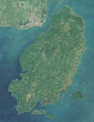
Panay is the sixth-largest and fourth-most populous island in the Philippines, with a total land area of 12,011 km2 (4,637 sq mi) and has a total population of 4,542,926 as of 2020 census. Panay comprises 4.4 percent of the entire population of the country. The City of Iloilo is its largest settlement with a total population of 457,626 inhabitants as of 2020 census.

Oriental Mindoro, officially the Province of Oriental Mindoro, is a province in the Philippines located on the island of Mindoro under Mimaropa region in Luzon, about 140 kilometres (87 mi) southwest of Manila. The province is bordered by the Verde Island Passage and the rest of Batangas to the north, by Marinduque, Maestre de Campo Island, Tablas Strait and the rest of Romblon to the east, by Semirara and the rest of Caluya Islands, Antique to the south, and by Occidental Mindoro to the west. Calapan, the only city in the island, is the provincial capital and Mimaropa's regional center.

Iloilo, officially the Province of Iloilo, is a province in the Philippines located in the Western Visayas region. Its capital and largest city is Iloilo City, the regional center of Western Visayas. Iloilo occupies a major southeast portion of the Visayan island of Panay and is bordered by the province of Antique to the west, Capiz to the north, the Jintotolo Channel to the northeast, the Guimaras Strait to the east, and the Iloilo Strait and Panay Gulf to the southwest.
Guimaras, officially the Province of Guimaras, is an island province in the Philippines located in the Western Visayas region. The capital is Jordan, while the largest local government unit for it is the municipality of Buenavista. The province is situated in Panay Gulf, between the islands of Panay and Negros. To the northwest is the province of Iloilo and to the southeast is Negros Occidental. The whole island is part of the Metro Iloilo–Guimaras, one of the twelve metropolitan areas of the Philippines.

Antique, officially the Province of Antique, is a province in the Philippines located in the Western Visayas region. Its capital is San Jose de Buenavista, the most populous town in Antique. The province is situated in the western section of Panay Island and borders Aklan, Capiz and Iloilo to the east, while facing the Sulu Sea to the west.

Capiz, officially the Province of Capiz, is a province in the Philippines located in the central section of Western Visayas region. Its capital is the city of Roxas. It is located at the northeastern portion of Panay Island, bordering Aklan to the north, Antique to the west, and Iloilo to the south. Capiz faces the Sibuyan Sea to the north.

Boracay is a resort island in the Western Visayas region of the Philippines, located 0.8 kilometers (0.50 mi) off the northwest coast of Panay. It has a total land area of 10.32 square kilometers (3.98 sq mi), under the jurisdiction of three barangays in Malay, Aklan, and had a population of 37,802 in 2020.

Roxas, officially the City of Roxas, is a 3rd class component city and capital of the province of Capiz, Philippines. According to the 2020 census, it has a population of 179,292 people.

Buruanga, officially the Municipality of Buruanga, is a 5th class municipality in the province of Aklan, Philippines. It is the farthest town of Aklan from its provincial capital. According to the 2020 census, it has a population of 19,357 people.

Barbaza, officially the Municipality of Barbaza, is a 4th class municipality in the province of Antique, Philippines. According to the 2020 census, it has a population of 23,359 people.

Culasi, officially the Municipality of Culasi, is a 3rd class municipality in the province of Antique, Philippines. According to the 2020 census, it has a population of 44,494 people. Making it fourth most populous municipality in the province of Antique and third largest municipality in terms of land area, with a total area of 228.56 square kilometers.
Carles, officially the Municipality of Carles, is a 2nd class municipality in the province of Iloilo, Philippines. According to the 2020 census, it has a population of 72,637 people.

Apo Island is a volcanic island covering 74 hectares in land area, 7 kilometers off the southeastern tip of Negros Island and 30 kilometers south of the Negros Oriental capital of Dumaguete in the Philippines. The name "Apo" means "elder" or "respected ancestor" in the Visayan languages.

Typhoon Fengshen, known in the Philippines as Typhoon Frank, was the sixth named storm and the fourth typhoon recognized by the Japan Meteorological Agency. The Joint Typhoon Warning Center recognized Fengshen as the seventh tropical depression, the sixth tropical storm, and fifth typhoon of the 2008 Pacific typhoon season.

The Maniguin Island Lighthouse is a lighthouse that marks the Cuyo East Passage, a main shipping route south into the Sulu Sea. The island, also known as Maningning Island or Hammerhead Island, is located 42.6 km off of the coast of Culasi, Antique in the Philippines. It has a narrow ridge 33.5 metres high across its southern end, and the remainder of the island is low and wooded, and not more than 4.5 metres high. It is fringed with coral reefs with deep water at their edges. The round cylindrical concrete tower with a gallery on top is located near the southeastern point of the island.

Sicogón is an island in northern Iloilo, which is part of the municipality of Carles, Iloilo, Philippines. It is named after cogon, a type of grass found in abundance on the island. According to the 2010 census, it has a population of 5,238.
The 1948 Lady Caycay earthquake occurred at 01:46 PST (UTC+08:00) on 25 January 1948 with an estimated moment magnitude of 7.8 and a maximum Mercalli intensity of X (Extreme). The epicenter was between the municipalities of Anini-y, Antique, and Dao on Panay Island, Philippines.
The Bugang River is a river situated in the northwest of Panay island in the Philippines. It is located in municipality of Pandan, Antique which is noted for its distinction as the "Cleanest Inland Body of Water" in the country.
Liwagao Island, also known as Libago Island or Libagao Island, is an island located southeast off the coast of Mindoro and northwest off Panay. The island is a disputed feature between the towns of Bulalacao, Oriental Mindoro and Caluya, Antique with the latter exercising de facto administration over the island.

The 1990 Panay earthquake occurred at 3:41 p.m. local time on 14 June 1990 with a moment magnitude of 7.1 in the Richter scale, leaving eight dead and 41 others injured. The epicenter was located at Culasi, Antique on Panay Island in the Philippines. The depth was computed to be 15 kilometers. It was generated by fault movement in the collisional zone off western Panay Island.


