
Saint Lucia is a constitutional monarchy and an island country of the West Indies in the eastern Caribbean. The island was previously called Iouanalao and later Hewanorra, names given by the native Arawaks and Caribs (respectively), two Amerindian peoples. Part of the Windward Islands of the Lesser Antilles, it is located north/northeast of the island of Saint Vincent, northwest of Barbados and south of Martinique. It covers a land area of 617 km2 with an estimated population of over 180,000 people as of 2018. The nation's capital and largest city is Castries.
Transport in Saint Lucia includes transportation to and from Saint Lucia, which is a sovereign island country located in the eastern Caribbean Sea. It also includes transportation from one part of the island to another.

Castries is the capital and largest city of Saint Lucia, an island country in the Caribbean. The urban area has a population of approximately 20,000, while the eponymous district has a population of 70,000, as at May 2013. The city covers 80 km2 (31 sq mi).

Hewanorra International Airport, located near Vieux Fort Quarter, Saint Lucia, in the Caribbean, is the larger of Saint Lucia's two airports and is managed by the Saint Lucia Air and Seaports Authority (SLASPA). It is on the southern cape of the island, about 53.4 km (33.2 mi) from the capital city, Castries.
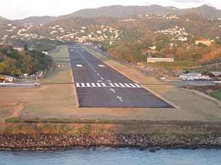
George F. L. Charles Airport is the smaller of the two airports in Saint Lucia, the other being Hewanorra International Airport. It is located 2 km (1.2 mi) north of Castries, the capital city. George F. L. Charles Airport is managed by the Saint Lucia Air and Seaports Authority (SLASPA). Its runway runs parallel to a pristine beach, Vigie Beach, which is a popular tourist attraction.

Vieux Fort is one of 10 districts of the Caribbean island country of Saint Lucia. Vieux Fort is also the name of the main town in the district. It is the home of the second-largest town in Saint Lucia and is the home of Saint Lucia's international airport, Hewanorra International Airport.

European route E20 is a part of the United Nations International E-road network. It runs roughly west–east through Ireland, the United Kingdom, Denmark, Sweden, Estonia, and Russia.

Air Sunshine is an airline based in the United States and in Puerto Rico. It operates scheduled service to and from San Juan and Vieques, Puerto Rico, St. Lucia, Anguilla, Dominica, Sint Maarten, Nevis, St. Kitts, Tortola and Virgin Gorda in the British Virgin Islands and Saint Thomas, US Virgin Islands. Its main base is Fort Lauderdale, with a Caribbean hub located in San Juan, Puerto Rico.

Tropical Storm Debby was a weak but costly tropical cyclone that affected the Lesser Antilles in September 1994. It was the fourth named tropical storm of the 1994 Atlantic hurricane season; it developed on September 9 east of Barbados. Debby made landfall on Saint Lucia early on September 10, producing heavy rainfall and tropical storm-force wind gusts. The rains caused flooding and landslides, damaging about half of the island's banana plantations. Several villages were isolated after roads and bridges were damaged. Damage totaled about $103 million (1994 USD). On nearby Dominica, Debby damaged crops and fisheries.

Pierrefonds Airport is an airport located 5.5 kilometres (3 NM) west-northwest of Saint-Pierre in Réunion. It is the smaller of the two airports located on the island, Roland Garros Airport being the other. The distance between the two airports is 49 km (30 mi) by air and 82 km (51 mi) by road.

Saint Lucia, an island nation in the Caribbean islands, has a relatively large tourism industry. Due to the relatively small land area of the country, most of the governmental promotion is performed by the state-operated Saint Lucia Tourism Authority, led by Executive Chairperson Agnes.

Beauvoir-de-Marc is a commune in the northern part of the Isère department. Isère is found in southeastern France, in the Auvergne-Rhône-Alpes region.
The following outline is provided as an overview of and topical guide to Saint Lucia:

Education in St. Lucia is primarily based on the British education system and is provided in public and private schools.

Verna is a village in Salcete, Goa, India, adjacent to the village of Nagoa. It is located approximately 10 km north of the South Goa district headquarters Margão, 18 km south-east of Vasco da Gama and 23 km south-east of the state capital Panjim.It has the hub of Verna Industrial Area where lot of people from different parts of India come to work in the production sector.
Goya Airport is an airport serving Goya, a town on the Paraná River in Corrientes Province, Argentina. The airport is 4 kilometres (2 mi) northeast of the town.
Aruvithura Church is a Syro-Malabar Catholic church located at Aruvithura,Eratupetta Kottayam district in the Kerala State of India. Traditionally it is believed that the Syrian Catholic Church at Erattupetta was established in AD 151.

Hurricane Dorian caused relatively minor damage across the eastern Caribbean in late August 2019. Originating from a westward moving tropical wave, Dorian organized into a tropical cyclone on August 24 and reached the Lesser Antilles on August 26 as a tropical storm. Turning northwest, the system unexpectedly intensified to a hurricane as it struck the Virgin Islands on August 27. Antecedent to the storm's arrival, local governments across the archipelago issued tropical cyclone warnings and watches, readied public shelters, closed airports, and placed emergency crews on standby. Many of the threatened islands were still reeling from the devastation wrought by Hurricane Irma and Hurricane Maria in September 2017 and fears arose over embattled power grids. In the areas first affected, impacts were limited to gusty winds and modest rainfall. Effects were greater in the Virgin Islands where wind gusts reached 111 mph (179 km/h); however, damage was light. Multiple landslides occurred across the islands and Puerto Rico with only a handful of structures suffering damage. One person died in Puerto Rico while preparing for the storm.
