
Penna is a river of southern India. This is a unique river in world where after originating from Nandi hills, it flows as two different streams, one in North and South directions. The Penna rises in the Nandi Hills in Chikkaballapur District of Karnataka state, and runs north and east through the states of Karnataka and Andhra Pradesh to empty into bay of bengal in Andhra Pradesh. It is 597 kilometres (371 mi) long, with a drainage basin covering 55,213 km2: 6,937 km2 in Karnataka and 48,276 km2 in Andhra Pradesh. Along with this main stream there is another stream south towards Tamilnadu with the name Then Pennai or south Pennar which further moves towards the east to empty into the Bay of Bengal. The Penna river basin lies in the rain shadow region of Eastern Ghats and receives 500 mm average rainfall annually.

Tumakuru district is an administrative district in the state of Karnataka in India. It is the third largest district in Karnataka by land area with an area of 10,598 km2, and fourth largest by Population. It is a one-and-a-half-hour drive from Bengaluru, the state capital. The district is known for the production of coconuts and is also called as 'Kalpataru Nadu'. It is the only discontiguous district in Karnataka.

The Hemavati is a river in southern India's Karnataka and an important tributary of the Kaveri.

Tumkur is a city located in the southern part of the Indian state of Karnataka. It is situated at a distance of 70 km (43 mi) northwest of Bangalore, the state capital, along NH 48 and NH 73, located at an altitude of 835 m (2739.5 ft). The city serves as the headquarters of Tumakuru district.
Chikkanayakanahalli is a town in Tiptur sub-division of Tumakuru district, in the state of Karnataka, India. It is 30 km away from Tiptur and 132 km from Bangalore.

Shimsha is a river that flows in the state of Karnataka, India. It is one of the tributaries of the river Kaveri, which is one of the major rivers of South India. The river originates in the southern part of the Devarayanadurga hill in the Tumkur district of Karnataka and flows for about 221 km (137 mi). before joining the river Kaveri.
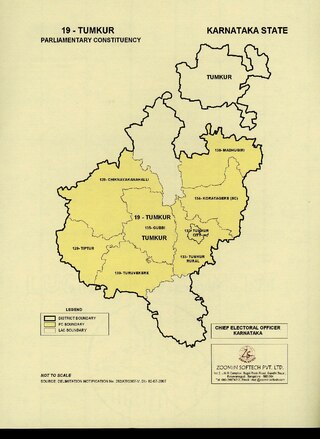
Tumkur is one of the 28 Lok Sabha constituencies in Karnataka state in southern India.

Hebbur is a village in the southern state of Karnataka, India. It is located in the Tumkur taluk of Tumkur district in Karnataka.
Kenkere is a small town in the southern state of Karnataka, India. It is located in the Chiknayakanhalli taluk of Tumkur district in Karnataka. It is the headquarters of the Village Panchayat.
Madalur is a village in the southern state of Karnataka, India. It is located in the Sira taluk of Tumkur district in Karnataka.
Abbanakuppe is a village in the southern state of Karnataka, India. It is located in the Gubbi taluk of Tumkur district.
Agalakote is a village in the southern state of Karnataka, India. It is located in the Tumkur taluk of Tumkur district in Karnataka.
Agarahara is a village in the southern state of Karnataka, India. It is located in the Tiptur taluk of Tumkur district in Karnataka.

Agrahara, Sira is a village in the southern state of Karnataka, India. It is located in the Sira taluk of Tumkur district in Karnataka.
Ahobala Agrahara is a village in the southern state of Karnataka, India. It is located in the Tumkur taluk of Tumkur district in Karnataka.
Ajjagonahalli is a village in the southern state of Karnataka, India. It is located in the Tumkur taluk of Tumkur district in Karnataka.
Ajjenahalli, Turuvekere is a village in the southern state of Karnataka, India. It is located in the Turuvekere taluk of Tumkur district in Karnataka.
Doddakalahalli is a village in Kunigal taluk of Tumkur district of the Indian state of Karnataka. The name of the village is derived from the rocky landscape - kallu meaning stone in Kannada. As of 2001 census, the population of the village was 722 with a literacy level of 52.10%. The Mysore general census of 1871 listed 14 houses in the village with a total population of 102.

Mallasandra is a village in Tumkur Taluk, Karnataka, 10 km from Tumkur City on NH-73 towards Gubbi.
Tumkur City is one of the 224 constituencies in the Karnataka Legislative Assembly of Karnataka, a southern state of India. It is also part of Tumkur Lok Sabha constituency. It represents Tumkur City.