Related Research Articles

The Never Summer Mountains are a mountain range in the Rocky Mountains in north central Colorado in the United States consisting of seventeen named peaks. The range is located along the northwest border of Rocky Mountain National Park, forming the continental divide between the headwaters of the Colorado River in Rocky Mountain National Park to the local-east and the upper basin of the North Platte River to the local-west; the continental divide makes a loop in these mountains. The range is small and tall, covering only 25 sq mi (65 km2) with a north–south length of 10 mi (16 km) while rising to over 12,000 ft (3,700 m) at over ten distinct peaks. The range straddles the Jackson-Grand county line for most of its length, and stretches into Jackson and Larimer county at its northern end. A panoramic view of the range is available from sections of Trail Ridge Road in Rocky Mountain National Park. One of the northernmost peaks, Nokhu Crags, is prominently visible from the west side of Cameron Pass.

The Athabasca Basin is a region in the Canadian Shield of northern Saskatchewan and Alberta, Canada. It is best known as the world's leading source of high-grade uranium and currently supplies about 20% of the world's uranium.

The San Juan Basin is a geologic structural basin located near the Four Corners region of the Southwestern United States. The basin covers 7,500 square miles and resides in northwestern New Mexico, southwestern Colorado, and parts of Utah and Arizona. Specifically, the basin occupies space in the San Juan, Rio Arriba, Sandoval, and McKinley counties in New Mexico, and La Plata and Archuleta counties in Colorado. The basin extends roughly 100 miles (160 km) N-S and 90 miles (140 km) E-W.
Uranium mining in the United States produced 173,875 pounds (78.9 tonnes) of U3O8 in 2019, 88% lower than the 2018 production of 1,447,945 pounds (656.8 tonnes) of U3O8 and the lowest US annual production since 1948. The 2019 production represents 0.3% of the anticipated uranium fuel requirements of the US's nuclear power reactors for the year.

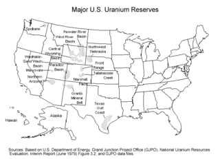
Uranium mining in Colorado, United States, goes back to 1872, when pitchblende ore was taken from gold mines near Central City, Colorado. The Colorado uranium industry has seen booms and busts, but continues to this day. Not counting byproduct uranium from phosphate, Colorado is considered to have the third largest uranium reserves of any US state, behind Wyoming and New Mexico.

Uranium mining in Wyoming was formerly a much larger industry than it is today. Wyoming once had many operating uranium mines, and still has the largest known uranium ore reserves of any state in the U.S. At the end of 2008, the state had estimated reserves dependent on price: 539 million pounds of uranium oxide at $50 per pound, and 1,227 million pounds at $100 per pound.

Uranium ore deposits are economically recoverable concentrations of uranium within the Earth's crust. Uranium is one of the most common elements in the Earth's crust, being 40 times more common than silver and 500 times more common than gold. It can be found almost everywhere in rock, soil, rivers, and oceans. The challenge for commercial uranium extraction is to find those areas where the concentrations are adequate to form an economically viable deposit. The primary use for uranium obtained from mining is in fuel for nuclear reactors.
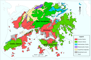
The geology of Hong Kong is dominated by igneous rocks formed during a major volcanic eruption period in the Mesozoic era. It made up 85% of Hong Kong's land surface and the remaining 15% are mostly sedimentary rocks located in the northeast New Territories. There are also a very small percentage of metamorphic rocks in the New Territories, formed by deformation of pre-existing sedimentary rocks (metamorphism).
SAG/SDAG Wismut was a uranium mining company in East Germany during the time of the Cold War. It produced a total of 230,400 tonnes of uranium between 1947 and 1990 and made East Germany the fourth largest producer of uranium ore in the world at the time. It was the largest single producer of uranium ore in the entire sphere of control of the USSR. In 1991 after German reunification it was transformed into the Wismut GmbH company, owned by the Federal Republic of Germany, which is now responsible for the restoration and environmental cleanup of the former mining and milling areas. The head office of SDAG Wismut / Wismut GmbH is in Chemnitz-Siegmar.
The West African Craton (WAC) is one of the five cratons of the Precambrian basement rock of Africa that make up the African Plate, the others being the Kalahari craton, Congo craton, Saharan Metacraton and Tanzania Craton. Cratons themselves are tectonically inactive, but can occur near active margins, with the WAC extending across 14 countries in Western Africa, coming together in the late Precambrian and early Palaeozoic eras to form the African continent. It consists of two Archean centers juxtaposed against multiple Paleoproterozoic domains made of greenstone belts, sedimentary basins, regional granitoid-tonalite-trondhjemite-granodiorite (TTG) plutons, and large shear zones. The craton is overlain by Neoproterozoic and younger sedimentary basins. The boundaries of the WAC are predominantly defined by a combination of geophysics and surface geology, with additional constraints by the geochemistry of the region. At one time, volcanic action around the rim of the craton may have contributed to a major global warming event.


The geology of Queensland can be subdivided into several regions with different histories. Along the east coast is a complex of Palaezoic to Cainozoic rocks while much of the rest of the state is covered by Cretaceous and Cainozoic rocks. A Precambrian basement is found in the north west and Cape York regions. The Thomson Orogen occurs in the central and southern parts of Queensland, but is mostly covered by younger basins.
Hajigak Mine is the best known and largest iron oxide deposit in Afghanistan, located near the Hajigak Pass, with its area divided between Maidan Wardak and Bamyan provinces. It has the biggest untapped iron ore deposits of Asia.

Mining is important to the national economy of Mongolia. Mongolia is one of the 29 resource-rich developing countries identified by the International Monetary Fund and exploration of copper and coal deposits are generating substantial additional revenue. Coal, copper, and gold are the principal reserves mined in Mongolia. Several gold mines are located about 110 kilometres (68 mi) north of Ulaanbaatar, such as Boroo Gold Mine and Gatsuurt Gold Mine. Khotgor Coal Mine is an open-pit coal mining site about 120 kilometres (75 mi) west of Ulaangom. Ömnögovi Province in the south of Mongolia is home to large scale mining projects such as the Tavan Tolgoi coal mine and the Oyu Tolgoi copper mine. Oyu Tolgoi mine is reported to have the potential to boost the national economy by a third but is subject to dispute over how the profits should be shared. The International Monetary Fund (IMF) has estimated that 71 percent of the income from the mine would go to Mongolia.

The Samail Ophiolite (also spelled Semail Ophiolite) of the Hajar Mountains of Oman and the United Arab Emirates is a large slab of oceanic crust, made of volcanic rocks and ultramafic rocks from the Earth's upper mantle, that was overthrust onto continental crust as an ophiolite. It is located on the eastern corner of the Arabian Peninsula and covers an area of approximately 100,000 km2. Based on uranium-lead dating techniques, the Samail Ophiolite formed in the Late Cretaceous. It is primarily made of silicate rocks with (SiO2) content ranging from 45–77 wt%. The Samail Ophiolite is important because it is rich in copper and chromite ore bodies, and because it also provides valuable information about the ocean floor and the upper mantle on land. Geologists have studied the area, attempting to find the best model explaining the formation of the Samail Ophiolite.

The geology of Germany is heavily influenced by several phases of orogeny in the Paleozoic and the Cenozoic, by sedimentation in shelf seas and epicontinental seas and on plains in the Permian and Mesozoic as well as by the Quaternary glaciations.
The Sable Tin Deposit also known as "Sobolinoye" is a high grade tin-copper deposit located in the Solnechny District of Khabarovsk Krai in the Russian Far East. Discovered in 1964 on the basis of 1:5000 – 1:10000 mapping which identified the presence of commercial concentrations of tin at surface. It is located within the Komsomolsk Ore (Tin) District, a major tin region within Russia with both historical and current mining activities. The deposit's resources were registered in 1987 and Technical Economic Conditions for design and construction were prepared by Gipronickel, a Norilsk subsidiary in 1993 but due to economic and political turbulence the deposit was never developed or exploited
Gabon is situated at the northwestern margin of the Congo Craton—a region of stable, ancient crust—and preserves very ancient rock units across 75% of the country, with overlying sedimentary units from the Cretaceous and other more recent periods.

The geology of Namibia encompasses rocks of Paleoproterozoic, Mesoproterozoic and Neoproterozoic and Paleozoic to Cenozoic age. About 46% of the countryʼs surface are bedrock exposure, while the remainder is covered by the young overburden sediments of the Kalahari and Namib deserts.
The geology of Nevada began to form in the Proterozoic at the western margin of North America. Terranes accreted to the continent as a marine environment dominated the area through the Paleozoic and Mesozoic periods. Intense volcanism, the horst and graben landscape of the Basin and Range Province originating from the Farallon Plate, and both glaciers and valley lakes have played important roles in the region throughout the past 66 million years.
References
- ↑ "Uranium in Mongolia". World Nuclear Association. January 11, 2011.
- ↑ "Business Opportunities with Oyu Tolgoi - 2010". Mongolia Web News. February 26, 2010. Archived from the original on August 26, 2010.
- ↑ "Geological Classification of Uranium Deposits and Description of Selected Examples, IAEA-TECDOC-1842" (PDF). International Atomic Energy Agency. 2018. Retrieved 3 September 2023.