Related Research Articles
Richard Siegmund Lindzen is an American atmospheric physicist known for his work in the dynamics of the middle atmosphere, atmospheric tides, and ozone photochemistry. He is the author of more than 200 scientific papers. From 1972 to 1982, he served as the Gordon McKay Professor of Dynamic Meteorology at Harvard University. In 1983, he was appointed as the Alfred P. Sloan Professor of Meteorology at the Massachusetts Institute of Technology, where he would remain until his retirement in 2013. Lindzen has disputed the scientific consensus on climate change and criticizes what he has called "climate alarmism".

A pileus, also called scarf cloud or cap cloud, is a small, horizontal, lenticular cloud appearing above a cumulus or cumulonimbus cloud. Pileus clouds are often short-lived, appearing for typically only a few minutes, with the main cloud beneath them rising through convection to absorb them. Furthermore, the clouds are typically formed by drier air with a higher lifting condensation level, which often prevents vertical growth and leads to the smooth horizontal cap shape that the cloud is named for.
Keith Anthony Browning is a British meteorologist who worked at Imperial College London, the Met Office, and the University of Reading departments of meteorology. His work with Frank Ludlam on the supercell thunderstorm at Wokingham, UK in 1962 was the first detailed study of such a storm. His well regarded research covered many areas of mesoscale meteorology including developing the theory of the sting jet. Arguably his greatest talent is his intuitive understanding of complex three-dimensional meteorological processes which he has described more simply using conceptual models.
A hot tower is a tropical cumulonimbus cloud that reaches out of the lowest layer of the atmosphere, the troposphere, and into the stratosphere. These formations are called "hot" because of the large amount of latent heat released as water vapor that condenses into liquid and freezes into ice within the cloud. Hot towers in regions of sufficient vorticity may acquire rotating updrafts; these are known as vortical hot towers In some instances, hot towers appear to develop characteristics of a supercell, with deep and persistent rotation present in the updraft. The role of hot towers in tropical weather was first formulated by Joanne Simpson in 1958. Hot towers dominated discussions in tropical meteorology in the 1960s and are now considered the main drivers of rising air within tropical cyclones and a major component of the Hadley circulation. Although the prevalence of hot towers in scientific literature decreased in the 1970s, hot towers remain an active area of research. The presence of hot towers in tropical cyclones is correlated with an increase in the tropical cyclones' intensities.

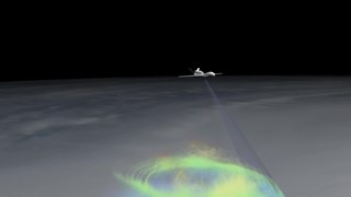
Ship tracks are clouds that form around the exhaust released by ships into the still ocean air. Water molecules collect around the tiny particles (aerosols) from exhaust to form a cloud seed. More and more water accumulates on the seed until a visible cloud is formed. In the case of ship tracks, the cloud seeds are stretched over a long narrow path where the wind has blown the ship's exhaust, so the resulting clouds resemble long strings over the ocean. Ship tracks are a type of homogenitus cloud.

In atmospheric science, an atmospheric model is a mathematical model constructed around the full set of primitive, dynamical equations which govern atmospheric motions. It can supplement these equations with parameterizations for turbulent diffusion, radiation, moist processes, heat exchange, soil, vegetation, surface water, the kinematic effects of terrain, and convection. Most atmospheric models are numerical, i.e. they discretize equations of motion. They can predict microscale phenomena such as tornadoes and boundary layer eddies, sub-microscale turbulent flow over buildings, as well as synoptic and global flows. The horizontal domain of a model is either global, covering the entire Earth, or regional (limited-area), covering only part of the Earth. Atmospheric models also differ in how they compute vertical fluid motions; some types of models are thermotropic, barotropic, hydrostatic, and non-hydrostatic. These model types are differentiated by their assumptions about the atmosphere, which must balance computational speed with the model's fidelity to the atmosphere it is simulating.

The Weather Research and Forecasting (WRF) Model is a numerical weather prediction (NWP) system designed to serve both atmospheric research and operational forecasting needs. NWP refers to the simulation and prediction of the atmosphere with a computer model, and WRF is a set of software for this. WRF features two dynamical (computational) cores, a data assimilation system, and a software architecture allowing for parallel computation and system extensibility. The model serves a wide range of meteorological applications across scales ranging from meters to thousands of kilometers.
Neil Burgher Ward was an American meteorologist who is credited as the first scientific storm chaser, developing ideas of thunderstorm and tornado structure and evolution as well as techniques for forecasting and severe weather intercept. He also was a pioneering developer of physical models of tornadoes, first at his home, then at the National Severe Storms Laboratory (NSSL) in Norman, Oklahoma. He significantly furthered the modern scientific understanding of atmospheric vortices, particularly tornadoes.
The maximum parcel level (MPL) is the highest level in the atmosphere that a moist convectively rising air parcel will reach after ascending from the level of free convection (LFC) through the free convective layer (FCL) and reaching the equilibrium level (EL), near the tropopause. As the parcel rises through the FCL it expands adiabatically causing its temperature to drop, often below the temperature of its surroundings, and eventually lose buoyancy. Because of this, the EL is approximately the region where the distinct flat tops, often observed around the upper portions of cumulonimbus clouds. If the air parcel ascended quickly enough then it retains momentum after it has cooled and continues rising past the EL, ceasing at the MPL.
The global horizontal sounding technique (GHOST) program was an atmospheric field research project in the late 1960s for investigating the technical ability to gather weather data using hundreds of simultaneous long-duration balloons for very long-range global scale numerical weather prediction in preparation for the Global Atmospheric Research Program (GARP).
Misoscale is an unofficial scale of meteorological phenomena that ranges in size from 40 metres (100 ft) to about 4 kilometres (2 mi). This scale was proposed by Ted Fujita, the founder of the Fujita scale, to classify phenomenon of the order of the rotation within a thunderstorm, the scale of the funnel cloud or a tornado, and the size of the swath of destruction of a microburst. It is a subdivision of the microscale.

Joanne Simpson was the first woman in the United States to receive a Ph.D. in meteorology, which she received in 1949 from the University of Chicago. Simpson received both her undergraduate and graduate degrees from the University of Chicago, and did post-doctoral work at Dartmouth College. She was a member of the National Academy of Engineering, and taught and researched meteorology at numerous universities as well as the federal government. Simpson contributed to many areas of the atmospheric sciences, particularly in the field of tropical meteorology. She has researched hot towers, hurricanes, the trade winds, air-sea interactions, and helped develop the Tropical Rainfall Measuring Mission (TRMM).

Hector is a cumulonimbus thundercloud cluster that forms regularly nearly every afternoon on the Tiwi Islands in the Northern Territory of Australia, from approximately September to March each year. Hector, or sometimes Hector the Convector, is known as one of the world's most consistently large thunderstorms; specifically, a small mesoscale convective system (MCS) or large multicellular thunderstorm. It reaches heights of approximately 20 kilometres (66,000 ft).
James C. McWilliams is a professor at the UCLA Institute of Geophysics and Planetary Physics and Department of Atmospheric and Oceanic Sciences.
A mesohigh is a mesoscale high-pressure area that forms beneath thunderstorms. While not always the case, it is usually associated with a mesoscale convective system. In the early stages of research on the subject, the mesohigh was often referred to as a "thunderstorm high".
Paul Rowland Julian, a Fellow of the American Meteorological Society, is an American meteorologist who served as a longtime staff scientist at the National Center for Atmospheric Research (NCAR), was co-author with Roland Madden of the study establishing the Madden–Julian oscillation (MJO), and contributed to the international, multi-institutional Global Atmospheric Research Program (GARP), Tropical Wind, Energy Conversion, and Reference Level Experiment (TWERLE), and Tropical Ocean-Global Atmosphere (TOGA) meteorology research programs. The MJO meteorologic phenomenon he co-discovered is the largest element of the intraseasonal variability in the tropical atmosphere, a traveling pattern arising from large-scale coupling between atmospheric circulation and tropical deep convection. Description of the MJO remains an important contribution to climate research with relevance to modern short- and long-term weather and climate modeling.
Roland Aloysius Madden, an American meteorologist, was a staff scientist at the National Center for Atmospheric Research (NCAR) from 1967 to 2002. His research centers on diagnostic studies of the atmosphere. Madden is a fellow of the American Meteorological Society (AMS) and a recipient of the 2002 Jule G. Charney Award of the AMS.

Roger M. Lhermitte was a French meteorologist who "pioneered the development of meteorological Doppler radar." His career extended from the 1950s until his death where he made numerous contributions to the field of radar meteorology resulting in over 100 publications and numerous patents.
Elizabeth Cicely Ridley was a British-American applied mathematician known for her work in numerical quantum chemistry and in climate modeling. The Roble–Dickinson–Ridley code that she and her collaborators created at the National Center for Atmospheric Research was the first general circulation model of the thermosphere.
Isidoro Orlanski is an Argentine-American atmospheric physicist, meteorologist, and ocean scientist. He is known for his contributions to the dynamics of weather systems and ocean currents, especially his work on mesoscale meteorology. Orlanski is currently an emeritus professor at Princeton University.
References
- ↑ Rittner, Don. (2003). LeMone, Margaret Anne. A to Z of Scientists inn Weather and Climate. pp. 96-97.
- ↑ "Dr. Margaret A. LeMone". Members. National Academy of Engineering. Retrieved 2024-01-29.
- ↑ Global Atmospheric Research Program (GARP) Atlantic Tropical Experiment (GATE). Earth Observing Laboratory. NCAR website.
- ↑ NCAR Archives Search results