Falak Sar is the highest mountain peak in Ushu Valley of Swat, Pakistan at an elevation of 5,918 metres (19,416 ft), it is considered the highest peak of the Swat district in the Hindu Kush mountains range, followed by Mankial mountain peak.

The Swat River is a perennial river in the northern region of Khyber-Pakhtunkhwa Province, Pakistan. The river commences in the Kalam Valley of Swat Kohistan with the confluence of two main tributaries Ushu and Utrar and runs downstream in a narrow gorge up to Baghdheri.

Utror, also spelt Atror, is a valley which is located in the Dir District of Khyber Pakhtunkhwa, Pakistan. It is surrounded by snow clad mountains, green pastures and waterfalls. The area of the valley is about 47,400 hectares. Utror is 16 km (9.9 mi) away from Kalam Valley and 116 km (72 mi) from Saidu Sharif.
Kalami (کالامي), also known as Gawri (ګاوری), Garwi, or Bashkarik, is a Dardic language spoken in Swat Kohistan region in the upper Swat District and in the upper Panjkora river valley of Upper Dir District, Khyber Pakhtunkhwa, Pakistan.

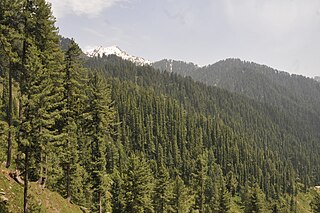
Kalam is a valley located at distance of 99 kilometres (62 mi) from Mingora in the northern upper reaches of Swat valley along the bank of Swat River in Khyber Pakhtunkhwa province of Pakistan. Kalam is surrounded by lush green hills, thick forests and bestowed with mesmeric lakes, meadows and waterfalls which are worth seen features of the landscape. It is the birthplace of Swat river which forms with confluence of two major tributaries of Gabral river and Ushu river.
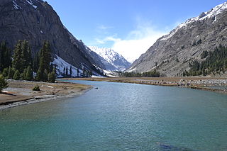
Mahodand Lake is a lake located in the upper Usho Valley at a distance of about 40 km from Kalam, Swat District, Khyber Pakhtunkhwa province of Pakistan. The lake is accessible by a four-wheel drive vehicle, and is often utilized for fishing and boating.

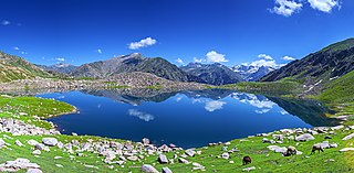
Kundol Lake also known as Kundol Dand, is a lake in Swat Valley, Khyber Pakhtunkhwa, Pakistan, which is located in the north of Utror valley at a distance of 20.8 kilometres (12.9 mi) away from kalam. Similarly, there is a well known story about the lake which is that every night in a month, a golden bowl appears in the center of the lake and glistens like moon but no one has ever touched that bowl due to magical powers inside it.

Bara Bandai is a village in swat Pakistan, known as an area crossed by Alexander The Great during his invasion of the subcontinent. The people of village Bara Bandai belong to subsection Naikpikhel of Yusufzai the biggest and largest tribe of Pashtun or Pakhtun tribes. It is one of the Provincially Administered Tribal Areas (PATA) of Pakistan. The village contains a small series of mountains and a forest, residential area starting from meadows of mountainsand merge with river swat on right bank, a village market, vast land for crops, number of canals, and a part of the Swat river. Mountains of the village include Usmani Sar, Kafar Ghat and Najia Top.
Ningolai is a village in swat(Khyber Pakhtoon Khwa) Pakistan. Old name was Ningula which was named by a person name Ningula. Later it was named Ningolai by the Rular of Swat State. The people of village Ningolai belong to subsection Naikpikhel of Yusufzai the biggest and largest tribe of Pashtun tribes. The village contains a small series of mountains and a forest, residential area starting from meadows of mountainsand merge with river swat on right bank, vast land for crops, number of canals, and a part of the Swat river. Mountains of the village include Usmani Ghar, Kursi Ghat, Kafar Ghat and Najia.

The White Palace of Marghazar was built in 1940 by the first king of Swat, Miangul Abdul Wadud in the small town of Marghazar situated at about 13 kilometers away from Saidu Sharif. The name was given to the palace as it was built of white marble. The palace now serves as a hotel. The White Palace at Marghazar was the summer residence of the Wali of Swat, Miangul Jehanzeb. Located at 7,000 feet above sea level on Marghazar Hill, it was later converted into a tourist resort.
The former princely state of Swat (1926-1969) was famous for its buildings, roads and architecture. These building show the quality and splendid architectural design of that time. These buildings serve as benchmarks of architecture, style and stability. A brief description of some of these buildings and structures are given below:

Khyber Pakhtunkhwa is located in the north-west region of Pakistan. It is known as the tourist hotspot for adventurers and explorers. The province has a varied landscape ranging from rugged mountains, valleys, hills and dense agricultural farms. The region is well known for its ancestral roots. There are a number of Buddhist archaeological sites from the Gandhara civilisation such as Takht Bhai and Pushkalavati. There are a number of other Buddhist and Hindu archaeological sites including Bala Hisar Fort, Butkara Stupa, Kanishka stupa, Chakdara, Panjkora Valley and Sehri Bahlol.

Bahrain is a town located in Swat District of Khyber Pakhtunkhwa, Pakistan, 60 km North of Mingora at an elevation of 4700 ft on the right bank of the Swat river. It is named Bahrain due to its location at the confluence of the Daral and Swat rivers. It is known for its riverside tourist resorts, local handicrafts, and its view of the merging of the Daral and Swat Rivers. It also serves as a base camp for the trail that leads to the Daral & Saidgai lakes.
Daral Lake also known Daral Dand is an alpine scenic lake in the hill top of Bahrain a region of Swat Valley in Khyber Pakhtunkhwa the Province of Pakistan. It is situated to the northeast of Saidgai Lake. The lake appears as giant amoeba like in shape and stretched over a huge area.Near the lake, there is an ancient mosque where shepherds and visitors offer their prayers and use it as a resting place for night.

Saidgai Lake also known as Saidgai Dand is a lake in the upper reaches of Ushirai Dara close to the Dir mountains, between the border of Swat District and Dir District of Khyber Pakhtunkhwa the Province of Pakistan. It is located at an elevation of 11,500 feet (3,500 m) above the sea level. It is located to the northwest of Gabin Jabba. The temperature is normally about 5 °C to 10 °C during hot months. Mostly this lake catches tourist form Dir and Swat and other parts of the country as well in the month of June, July and August, while the remaining months this lake is covered by snow and impossible for the tourist to stay there. Saidgai lake is the boundary between Swat valley and Dir Upper.
The Board of Intermediate and Secondary Education Swat is an educational governmental body in Malakand Division, which conducts the exams, assign duties, and register the educational institutes in the region.

Kalam festival, kalam mela or Swat Summer festival is a cultural and recreational event, held every year in the month of July or August in the scenic valley of Kalam and Mahodand,100 kilometers from Swat city, Pakistan. The festival is arranged in the pattern of Shandur Polo festival. The days, when plan areas of Pakistan are hot and humid, tourists are enjoying cold weather in Kalam and the tent village;Mahudand. The festival is organized by Khyber Pakhtunkhwa Tourism Department in collaboration with the Pakistan Army. Sports, cultural and recreational activities are arranged during the week.