
Hardap is one of the fourteen regions of Namibia, its capital is Mariental. Hardap contains the municipality of Mariental, the towns Rehoboth and Aranos, and the self-governed villages Gibeon, Gochas, Kalkrand, Stampriet and Maltahöhe. It is home to the Hardap Dam.
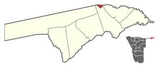
Katima Mulilo UrbanConstituency is an electoral district in Namibia. It is situated in the Zambezi Region. The region's capital, Katima Mulilo, is in this constituency. The constituency has a population of 28,362 people. In the 2020 Regional Council Elections, there were 13,860 registered voters.

Katima Mulilo Rural is a constituency in the Zambezi Region of Namibia. It comprises the area south of the town of Katima Mulilo, the regional capital. As of 2020, the constituency had 6,712 registered voters.

Khomasdal Constituency is a constituency in Windhoek in the Khomas Region of Namibia. As of December 2019 it had 25,550 registered voters. The constituency consists of parts of the suburbs Khomasdal, Katutura, and Otjomuise. It had a population of 43,921 in 2011, up from 27,950 in 2001.

Mariental is a town of 10,000 inhabitants in south-central Namibia, lying on the B1 national road 232 kilometres (144 mi) north of Keetmanshoop and 274 kilometres (170 mi) southeast of Windhoek. It lies at an elevation of 1,090 metres (3,580 ft). Mariental is connected to the TransNamib railway line from Windhoek to Keetmanshoop. The town and the surrounding area are situated in a hot, arid region.

Rehoboth Rural is an electoral constituency in the Hardap region of Namibia. It had a population of 7,288 in 2011, down from 7,524 in 2001. The constituency office is in Schlip. Other settlements in Rehoboth Rural are Klein Aub, Khauxas and Rietoog. As of 2020, the constituency had 4,701 registered voters.

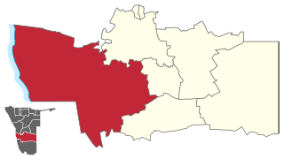
Rehoboth Urban West is an electoral constituency in the Hardap region of Namibia, comprising the suburbs of Rehoboth that are situated to the west of the national road B1. It had a population of 11,197 in 2011, up from 9,238 in 2001. As of 2020 the constituency had 8,324 registered voters.

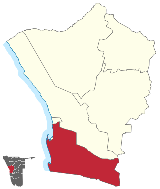
Rehoboth Urban East is an electoral constituency in the Hardap region of Namibia, comprising the suburbs of Rehoboth that are situated to the east of the national road B1. It had a population of 18,035 in 2011, up from 12,891 in 2001. As of 2020 the constituency had 12,112 registered voters.

Mariental Rural is a constituency in the Hardap region of Namibia. Its constituency office is situated in Stampriet. It had a population of 15,308 in 2011, up from 13,946 in 2001.

Stampriet is a village in Hardap Region, Namibia. It is located 64 km north-east of Mariental and 1,177 metres (3,862 ft) above sea level, in a barren area on the upper reaches of the Auob River where humans and animals alike depend on borehole water. Stampriet is the administrative center of the Mariental Rural electoral constituency.

Gibeon is a constituency in the Hardap Region of Namibia. The administrative centre of the constituency is the village of Gibeon. It had a population of 12,122 in 2011, up from 11,541 in 2001.

Oniipa Constituency is an electoral constituency in the Oshikoto Region of Namibia. It had 23,913 inhabitants in 2004 and 14,236 registered voters in 2020. The constituency office is situated in the settlement of Oniipa. Further settlements in this constituency are Oshigambo, and Onandjokwe.

Aranos is a town in the Hardap Region of central Namibia, situated in the Nossob River basin in the Kalahari Desert.

Swakopmund constituency is a constituency in the Erongo Region of Namibia. The constituency had a population of 44,725 in 2011, up from 26,310 in 2001. The coverage of the constituency and its district capital is the city of Swakopmund. As of 2020 the constituency had 35,668 registered voters.
Walvis Bay Rural constituency is a constituency in the Erongo Region of Namibia. It comprises the rural area surrounding the constituency's district capital city of Walvis Bay, and additionally some streets on the outskirts of the city. It had a population of 26,916 in 2011, up from 16,293 in 2001. As of 2020 the constituency had 25,746 registered voters.

Walvis Bay Urban is a constituency in the Erongo Region of Namibia, comprising most of the city of Walvis Bay. It had a population of 35,828 in 2011, up from 27,941 in 2001. As of 2020 the constituency had 25,311 registered voters.

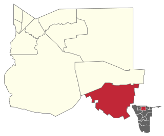
Aranos Constituency is an electoral constituency in the Hardap Region of Namibia. It was created in August 2013, following a recommendation of the Fourth Delimitation Commission of Namibia, and in preparation of the 2014 general election. Aranos constituency was formed from the eastern part of Mariental Rural constituency. The administrative centre of Aranos Constituency is the town of Aranos. As of 2020 the constituency had 5,604 registered voters.
Daweb Constituency is an electoral constituency in the Hardap Region of Namibia. It was created in August 2013, following a recommendation of the Fourth Delimitation Commission of Namibia, and in preparation of the 2014 general election. Daweb constituency was formed from the western part of Gibeon Constituency.
Tsumeb Constituency is an electoral constituency in the Oshikoto Region of Namibia, comprising the town area and surroundings of Tsumeb. It had a population of 44,113 in 2004 and 19,065 registered voters in 2020.

Local and regional elections were held in Namibia on 25 November 2020 to elect new local and regional councils. The previous round of elections was held in 2015 and won by the ruling SWAPO party.
