Marindahl Lake

Last updated
Marindahl Lake
USA South Dakota relief location map.svg
Red pog.svg
Marindahl Lake
Usa edcp relief location map.png
Red pog.svg
Marindahl Lake
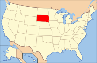
Location Yankton County, near Volin, South Dakota
Coordinates 43°02′14″N97°15′22″W / 43.03722°N 97.25611°W / 43.03722; -97.25611
Basin  countriesUnited States
Surface area106.81 acres (43.22 ha)
Surface elevation1,322 ft (403 m)

Marindahl Lake is a small lake located north of the city of Volin, South Dakota.

Marindahl Lake, in South Dakotas's Southeast Region, isn't the kind of lake you'll find on lists of the world's greatest lakes. Indeed, you may not be able to find it on any lists of commonly-known lakes. The lake is relatively unknown outside of the immediate area of South Dakota, keeping it uncrowded and a haven for nature lovers. Marindahl Reservoir was created when Clay Creek (a tributary of the Vermillion River) was dammed. The purpose of the reservoir is to provide wildlife habitat and recreational opportunities in the area. The small 139-acre lake boasts a tree-shaded shoreline and areas of 100-foot cliffs towering above the water. Because this is a 'no wake' lake, the quiet waters are ideal for canoeing and kayaking. Recently popularized by canoeists, many canoeing bloggers comment on the shimmer produced as the sun sets across the surface. Marindahl Lake provide a welcome contrast to larger, better-known recreational lakes in the area.

The area of the state that now holds Marindahl Lake saw the Lewis and Clark Expedition pass through on their exploration of the northwestern lands of the Louisiana Purchase. Once the lands of the Yankton Sioux, the area was sold by treaty to the United States government in 1852 and quickly settled by farmers. The two largest cities in the area - Yankton and Sioux Falls - were both plotted by land speculators. Nearby Vermillion maintains a museum dedicated in part to the Lewis and Clark Expedition, as does Yankton. The process of turning the thick prairie sod in order to grow wheat was difficult for the early settlers. Taming the land also degraded the streams and rivers with sediment from run-off. For many years, fishing in the southeastern corner of South Dakota took a backseat to farming. Fishing and wildlife suffered for lack of habitat. Fortunately, modern recognition of the importance of clean water and wildlife habitat caused major investment to be made in restoring the environment to health. Marindahl Lake is a part of that success story.

Because the entire shoreline of Marindahl Lake belongs to the South Dakota Department of Game, Fish and Parks, there is no development directly along the shore. A total of 634 acres of public land is available for recreation and hunting around the lake. The only boat ramp extending into the waters is the Game, Fish and Parks dock near the dam at the south end of the lake. Because of the natural state of the lakeshore, it is easy for a solo paddler to believe himself in undiscovered territory. One may occasionally see another boat, or a fisherman fishing from the shore, but often the visiting paddler has the lake himself. Gliding silently long the shoreline, one is likely to see a variety of waterfowl, small mammals, muskrat, song birds, turtles, herons, terns and an occasional eagle. Deer can occasionally be spotted drinking in the shallows. Feeding fish ripple the still surface of the lake and the occasional bass makes a resounding splash as it rises to snatch a tempting insect in mid-air. Anglers visit Marindahl Lake to stalk the wily largemouth bass and to take their limit of bluegill, black crappie and green sunfish. Channel Catfish are beginning to reach fish-able numbers and size in the lake. Because the lake was over-populated with common carp and bullhead, the water was chemically treated a few years ago to remove them, and more sought-after fish planted. A stocking program plants fingerlings regularly based on fish population monitoring. In winter, the lake is a favorite for ice fishing.

No facilities other than toilets are provided at the boat access area. There are no camping, picnicking or playground facilities provided. During hunting season, hunters park at the provided road-ends and walk to their chosen spots. The lack of facilities and organized trails keeps the public lands around the lake secluded and seldom used except by serious sportsmen. This seclusion is much appreciated by bird-watcher and wildlife viewers.

Visitors to the lake usually avail themselves of the vacation rentals and hotel-style lodgings near Yankton or Vermillion. Occasionally, cottages may become available around the small towns of Irene, Wakonda, Volin or Gayville. Often those wishing to make a true vacation of a trip to Marindahl Lake take advantage of the campgrounds at the Lewis and Clark Recreation Area just west of Yankton. Here, they can entertain themselves along the Missouri River and Lewis and Clark Lake. All types of water sports are enjoyed here, including larger sailboats and power boating. Real estate is available in the area between Marindahl Lake and Yankton and a ranchette purchase is certainly a possibility.

For the family with children, the entertainment venues available in the Yankton area will keep them busy while the fisher folk of the family make the 20 mile trip to Marindahl Lake. An interesting side-excursion in Yankton is the Dakota Territory Museum, with its full complement of early area settler history, Native American historical facts and information and artifacts from the Lewis and Clark Expedition. The small city has art galleries, theatres, golf courses and even wineries nearby.

See also

Related Research Articles

<span class="mw-page-title-main">Yankton County, South Dakota</span> County in South Dakota, United States

Yankton County is a county in the U.S. state of South Dakota. As of the 2020 census, the population was 23,310, making it the 9th most populous county in South Dakota. Its county seat is Yankton. Yankton County comprises the Yankton, SD Micropolitan Statistical Area.

<span class="mw-page-title-main">Yankton, South Dakota</span> City in South Dakota, United States

Yankton is a city in and the county seat of Yankton County, South Dakota, United States.

<span class="mw-page-title-main">Yellowstone River</span> River in the western United States

The Yellowstone River is a tributary of the Missouri River, approximately 692 miles (1,114 km) long, in the Western United States. Considered the principal tributary of upper Missouri, via its own tributaries it drains an area with headwaters across the mountains and high plains of southern Montana and northern Wyoming, and stretching east from the Rocky Mountains in the vicinity of Yellowstone National Park. It flows northeast to its confluence with the Missouri River on the North Dakota side of the border, about 25 miles west of present-day Williston.

<span class="mw-page-title-main">Lake Sharpe</span> Reservoir in South Dakota, United States

Lake Sharpe is a large reservoir impounded by Big Bend Dam on the Missouri River in central South Dakota, United States. The lake has an area of 56,884 acres (230.20 km2) and a maximum depth of 78 ft (24 m). Lake Sharpe is approximately 80 mi (130 km) long, with a shoreline of 200 mi (320 km). Lake Sharpe is the 54th largest reservoir in the United States. The lake starts near Ft. Thompson and stretches upstream to Oahe Dam, near Pierre. The lake is located within the following counties: Buffalo, Lyman, Hyde, Hughes, and Stanley. The Big Bend of the Missouri is about 7 miles (11 km) north of the dam.

<span class="mw-page-title-main">Sauk River (Minnesota)</span>

The Sauk River is a 122-mile-long (196 km) tributary of the Mississippi River in central Minnesota in the United States. It drains small lakes in Stearns County. In the Ojibwe language it is called Ozaagi-ziibi, meaning "River of the Sauks".

<span class="mw-page-title-main">Cave Run Lake</span> Man-made lake in Kentucky, United States

Cave Run Lake, located south of Morehead, Kentucky, USA along Kentucky Route 801, is an 8,270-acre (33 km2) reservoir built by the U.S. Army Corps of Engineers. The 148 feet (45 m), half-mile dam construction began in 1965 and was completed in 1973. Cave Run Lake is in the northern part of the Daniel Boone National Forest. Cave Run Lake provides flood protection to the lower Licking River valley, supplies water to the area's communities, improves the Licking River's water flow conditions, and offers a habitat for various species of fish and wildlife. It is in Rowan, Morgan, Menifee, and Bath counties.

<span class="mw-page-title-main">Gavins Point Dam</span> Dam in Nebraska and Yankton County, South Dakota.

Gavins Point Dam is a 1.9-mile-long (3 km) embankment rolled-earth and chalk-fill dam which spans the Missouri River and impounds Lewis and Clark Lake. The dam joins Cedar County, Nebraska with Yankton County, South Dakota a distance of 811.1 river miles (1,305 km) upstream of St. Louis, Missouri, where the river joins the Mississippi River. The dam and hydroelectric power plant were constructed as the Gavins Point Project from 1952 to 1957 by the United States Army Corps of Engineers as part of the Pick-Sloan Plan. The dam is located approximately 4 miles (6.4 km) west or upstream of Yankton, South Dakota.

<span class="mw-page-title-main">Lewis and Clark Lake</span> Man-made lake in Nebraska and South Dakota, United States

Lewis and Clark Lake is a 31,400 acre (130 km²) reservoir located on the border of the U.S. states of Nebraska and South Dakota on the Missouri River. The lake is approximately 25 miles (40 km) in length with over 90 miles (140 km) of shoreline and a maximum water depth of 45 feet (14 m). The lake is impounded by Gavins Point Dam and is managed by the U.S. Army Corps of Engineers, Omaha District.

The Missouri National Recreational River is a National Recreational River located on the border between Nebraska and South Dakota. The designation was first applied in 1978 to a 59-mile section of the Missouri River between Gavins Point Dam and Ponca State Park. In 1991, an additional 39-mile section between Fort Randall Dam and Niobrara, Nebraska, was added to the designation. These two stretches of the Missouri River are the only parts of the river between Montana and the mouth of the Missouri that remain undammed or unchannelized. The last 20 miles of the Niobrara River and 6 miles of Verdigre Creek were also added in 1991.

The history of South Dakota describes the history of the U.S. state of South Dakota over the course of several millennia, from its first inhabitants to the recent issues facing the state.

The Water Resources Development Act of 1999, Pub. L.Tooltip Public Law  106–53 (text)(PDF), was enacted by Congress of the United States on August 17, 1999. Most of the provisions of WRDA 1999 are administered by the United States Army Corps of Engineers.

<span class="mw-page-title-main">Hart Lake (Oregon)</span> Lake of the United States of America

Hart Lake is a shallow lake in the Warner Valley of eastern Lake County, Oregon, United States. The lake covers 7,324 acres (29.64 km2) and has the most stable water level within the valley's Warner Lakes chain. The lake is named for the heart-shaped brand used by the pioneer Wilson and Alexander cattle ranch established near the lake. Much of the land around Hart Lake is administered by the Bureau of Land Management (BLM) and the United States Fish and Wildlife Service (FWS). The lake and the surrounding wetlands support a wide variety of birds and other wildlife. Recreational opportunities on and near Hart Lake include hunting, fishing, bird watching, and boating.

<span class="mw-page-title-main">Lake Yankton (South Dakota)</span> Reservoir in Yankton County, South Dakota

Lake Yankton, also called Cottonwood Lake, is an artificial lake that was originally part of the main channel of the Missouri River on the border of the U.S. States of Nebraska and South Dakota, near Yankton, South Dakota. The lake has an approximate surface area of 250 acres (100 ha) and has a maximum depth of 18 feet (5.5 m). The lake is located immediately downstream (east) of Gavins Point Dam and Lewis and Clark Lake, located just north of the current location of the main channel of the Missouri River.

<span class="mw-page-title-main">South Dakota Department of Game, Fish, and Parks</span>

The South Dakota Department of Game, Fish, and Parks (GFP) is the U.S. State of South Dakota's state agency charged with the management of the state's public recreational and outdoor resources. The GFP manages the 13 state parks and 43 state recreation areas within the state parks system, totaling over 96,000 acres of public lands. The agency manages the hunting of game and the state's fisheries, manages several wildlife management areas and game production areas to restore or establish habitat for a variety of species. The agency conducts public outdoor education programs, typically focusing on hunting and boating safety. The department issues hunting and fishing licenses along with issuance of boat registrations. The agency is also charged with enforcement of fish and game laws, including invasive species regulations. The agency is headquartered in Pierre, South Dakota.

<span class="mw-page-title-main">Lewis & Clark Recreation Area</span> State recreation area in Yankton County, South Dakota, United States

Lewis and Clark Recreation Area is a State Recreation Area in southeastern South Dakota, near Yankton. The Recreation Area is located on the northern shore of the 31,400-acre Lewis and Clark Lake, a large Missouri River Reservoir, impounded by Gavins Point Dam.

<span class="mw-page-title-main">Lewis and Clark State Recreation Area (Nebraska)</span> Recreation area in Nebraska, United States

Lewis and Clark State Recreation Area (SRA) is an 864-acre (350 ha) State Recreation Area located on the southern shore of Lewis and Clark Lake, in northeastern Nebraska. The recreation area is located in Knox County, approximately 12 miles (19 km) northwest of Crofton. The recreation area is managed by the Nebraska Game and Parks Commission.

<span class="mw-page-title-main">Chief White Crane Recreation Area</span> State recreation area in South Dakota, United States

Chief White Crane Recreation Area is a state recreation area in southeastern South Dakota, United States. It is located about 5 miles (8.0 km) west of Yankton and located on the shores of the Missouri River and Lake Yankton. The recreation area is located about 1.5 miles (2.4 km) downstream of Gavins Point Dam and Lewis and Clark Lake.

Pierson Ranch Recreation Area is a state recreation area in Yankton County, South Dakota in the United States. The recreation area is 60 acres (24 ha) and lies directly below Gavins Point Dam and Lewis and Clark Lake and is adjacent to Lake Yankton. The area is open for year-round recreation including camping, swimming, fishing, hiking and boating. It is 4 miles (6.4 km) west of Yankton.

<span class="mw-page-title-main">Training Dike Recreation Area</span>

Training Dike Recreation Area, also called Training Dike Day-Use Area is a U.S. Army Corps of Engineers public recreation area located immediately downstream of Gavins Point Dam and Lewis and Clark Lake on the north bank of the Missouri River. The area is about 4.5 miles (7.2 km) west of Yankton. The area is located mostly in Cedar County, Nebraska, with a small portion located in Yankton County, South Dakota.

Springfield Recreation Area is a state recreation area in Bon Homme County, South Dakota in the United States. The recreation area is located on the upper part of Lewis and Clark Lake, and is popular for boating, fishing, and hunting. There is a 20-site campground and a boat launch to access the lake and the Missouri River. The area is about 30 miles west of Yankton.