
Hometown is a village in Rush Township, Schuylkill County, Pennsylvania, United States that sits astride a crossing point between important transportation corridors. The population was 1,399 at the 2000 census, and excepting for the area near the east-west PA 54 running mostly parallel to the tracks of the Reading, Blue Mountain, and Northern Railroad — once the important E-W shortline Nesquehoning & Mahanoy Railroad — and the PA 54 junction with PA 309.

Skeppsholmen is one of the islands of Stockholm. It is connected with Blasieholmen and Kastellholmen by bridges. It is accessible by foot from Kungsträdgården, past the Grand Hôtel and Nationalmuseum, by bus number 65, or by boat from Slussen, Djurgården or Nybroplan.

Choteč is a village in the Pardubice Region of the Czech Republic. It has around 280 inhabitants.

Trouville-Deauville is the station for the towns of Deauville and Trouville-sur-Mer. The station is built in neo-normand architecture and is a terminus for two railway lines, the main line from Paris by Lisieux and the Côte Fleurie branchline to Dives-Cabourg.

Junggok Station is a station on the Seoul Subway Line 7. It is the closest station to Daewon Foreign Language High School.

Gościęcice, formerly known as Mehltheuer, is a village in the administrative district of Gmina Strzelin, within Strzelin County, Lower Silesian Voivodeship, in south-western Poland. Prior to 1945, it was in Germany.
Museum of Ostad Bohtouni is a museum in Tabriz, north-western Iran. Handcrafts of artist Bohtouni are kept in this museum, including sculptures of different stuffs like flowers, fruits etc.
Bargen is a hamlet in the northwest Netherlands, on the island and in the municipality of Texel, North Holland. It is located 4 km northeast of Den Burg.
Krzywe is a village in the administrative district of Gmina Suwałki, within Suwałki County, Podlaskie Voivodeship, in north-eastern Poland. It lies approximately 5 kilometres (3 mi) east of Suwałki and 108 km (67 mi) north of the regional capital Białystok.
Chamtar is a town and union council of Mardan District in Khyber Pakhtunkhwa province of Pakistan. It is located at 34°10'47N 71°59'2E and has an altitude of 286 metres.
Chałupki is a village in the administrative district of Gmina Przeworsk, within Przeworsk County, Subcarpathian Voivodeship, in south-eastern Poland.
Wymysław is a village in the administrative district of Gmina Chodzież, within Chodzież County, Greater Poland Voivodeship, in west-central Poland. It lies approximately 8 kilometres (5 mi) north-east of Chodzież and 70 km (43 mi) north of the regional capital Poznań.
Liniewskie Góry is a village in the administrative district of Gmina Liniewo, within Kościerzyna County, Pomeranian Voivodeship, in northern Poland. It lies approximately 2 kilometres (1 mi) north-west of Liniewo, 16 km (10 mi) east of Kościerzyna, and 42 km (26 mi) south-west of the regional capital Gdańsk.
Tulno is a village in the administrative district of Gmina Pasłęk, within Elbląg County, Warmian-Masurian Voivodeship, in northern Poland. It lies approximately 11 kilometres (7 mi) south-east of Pasłęk, 28 km (17 mi) south-east of Elbląg, and 53 km (33 mi) north-west of the regional capital Olsztyn.
Miłkowo is a settlement in the administrative district of Gmina Biały Bór, within Szczecinek County, West Pomeranian Voivodeship, in north-western Poland. It lies approximately 10 kilometres (6 mi) north of Biały Bór, 32 km (20 mi) north of Szczecinek, and 162 km (101 mi) north-east of the regional capital Szczecin.
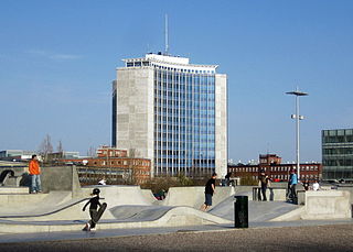
Stapelbäddsparken is a skateboarding park in Malmö, Sweden. It was designed by Stefan Hauser.

Krivajevići is a village in the municipality of Ilijaš, Bosnia and Herzegovina.
Sidi Nâamane is a town and commune in Tizi Ouzou Province in northern Algeria.
Davah Dashi is a village in Garmeh-ye Jonubi Rural District, in the Central District of Meyaneh County, East Azerbaijan Province, Iran. At the 2006 census, its population was 210, in 34 families.
Yeni Sivas 4 Eylül Stadyumu is a stadium in Sivas, Turkey. It opened in 2016 and is the new home of Sivasspor of the Süper Lig. The stadium has a capacity of 25,000 spectators, and replaced the club's previous home, 4 Eylül Stadium. The new stadium is also known as 4 Eylül Stadium.


