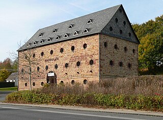
A tithe barn was a type of barn used in much of northern Europe in the Middle Ages for storing rents and tithes. Farmers were required to give one-tenth of their produce to the established church. Tithe barns were usually associated with the village church or rectory, and independent farmers took their tithes there. The village priests did not have to pay tithes—the purpose of the tithe being their support. Some operated their own farms anyway. The former church property has sometimes been converted to village greens.

Rochdale is a town in Greater Manchester, England, and the administrative centre of the Metropolitan Borough of Rochdale. In the 2021 census the town had a population of 111,261, compared to 223,773 for the wider borough. Rochdale is in the foothills of the South Pennines and lies in the dale (valley) of the River Roch, 5 miles (8 km) northwest of Oldham, and 10 miles (16 km) northeast of Manchester.

Whalley is a large village and civil parish in the Ribble Valley on the banks of the River Calder in Lancashire, England. It is overlooked by Whalley Nab, a large wooded hill over the river from the village. The population of the civil parish was 2,645 at the census of 2001, and increased to 3,629 at the census of 2011.
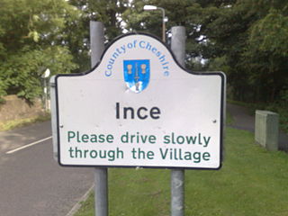
Ince is a village and civil parish in the unitary authority of Cheshire West and Chester and the ceremonial county of Cheshire, England. It is situated immediately to the east of the Stanlow Oil Refinery. It shares Ince & Elton railway station with the village of Elton, which it runs into.

Sawley Abbey was an abbey of Cistercian monks in the village of Sawley, Lancashire, in England. Created as a daughter-house of Newminster Abbey, it existed from 1149 until its dissolution in 1536, during the reign of King Henry VIII.
Hundersfield was a manor, parish and, from 1746, township, within the parish of Rochdale, in the hundred of Salford, England. It straddled the historic county boundary between Lancashire and the West Riding of Yorkshire. There are written references to the parish dating back to 1202.

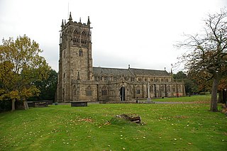
Whalley Abbey is a former Cistercian abbey in Whalley, Lancashire, England. After the dissolution of the monasteries, the abbey was largely demolished and a country house was built on the site. In the 20th century the house was modified and it is now the Retreat and Conference House of the Diocese of Blackburn of the Church of England. The ruins of the abbey are recorded in the National Heritage List for England as a designated Grade I listed building, and are a Scheduled Ancient Monument.
The Abbey of St. Mary at Stanlaw, was a Cistercian foundation situated on Stanlaw - now Stanlow Point, on the banks of the River Mersey in the Wirral Peninsula, Cheshire, England, near Ellesmere Port, 11 km north of Chester Castle and 12 km south-west of Halton Castle.

Butterworth was a township occupying the southeastern part of the parish of Rochdale, in the hundred of Salford, Lancashire, England. It encompassed 12.1 square miles (31 km2) of land in the South Pennines which spanned the settlements of Belfield, Bleaked-gate-cum-Roughbank, Butterworth Hall, Clegg, Haughs, Hollingworth, Kitcliffe, Lowhouse, Milnrow, Newhey, Ogden, Rakewood, Smithy Bridge, Tunshill and Wildhouse. It extended to the borders of Crompton to the south, and to the highest points of Bleakedgate Moor and Clegg Moor, up to the ridge of Blackstone Edge, to the east, where its boundary was the old county boundary between Lancashire and Yorkshire.

Buckley is a suburban area within the Metropolitan Borough of Rochdale, in Greater Manchester, England. It lies at the northern fringe of Rochdale, along the course of Buckley Brook, "upon an eminence of ground" by the South Pennines. It is 1.2 miles (1.9 km) south-southwest of the village of Wardle and 1.3 miles (2.1 km) north-northeast of Rochdale's town centre. Buckley spans a watercourse, a prison, farmland and residential properties.
Rochdale was an ecclesiastical parish of early-medieval origin in northern England, administered from the Church of St Chad, Rochdale. At its zenith, it occupied 58,620 acres (237 km2) of land amongst the South Pennines, and straddled the historic county boundary between Lancashire and the West Riding of Yorkshire. To the north and north-west was the parish of Whalley; to the southwest was the parish of Bury; to the south was Middleton and Prestwich-cum-Oldham.

Lytham Hall is an 18th-century Georgian country house in Lytham, Lancashire, 1 mile (1.6 km) from the centre of the town, in 78 acres (32 ha) of wooded parkland. It is recorded in the National Heritage List for England as a designated Grade I listed building, the only one in the Borough of Fylde.

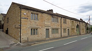
Saighton Grange originated as a monastic grange. It was later converted into a country house and, as of 2013, the building is used as a school. It is located in Saighton, Cheshire, England. The only surviving part of the monastic grange is the gatehouse, which is recorded in the National Heritage List for England as a designated Grade I listed building, and is one of only two surviving monastic manorial buildings in Cheshire, the other being Ince Manor. The rest of the building is listed at Grade II, as is its chapel.
Read Hall and Park is a manor house with ornamental grounds of about 450 acres (180 ha) in Whalley Road, Read, a few miles west of Padiham, Lancashire, England.
Easington is a civil parish within the Ribble Valley district of Lancashire, England, with a population in 2001 of 52. The Census 2011 population details have been grouped with the parish of Slaidburn. Before 1974, it formed part of Bowland Rural District in the West Riding of Yorkshire. It covers just over 9000 acres.
Whalley is a civil parish in Ribble Valley, Lancashire, England. It contains 29 listed buildings that are recorded in the National Heritage List for England. Of these, three are listed at Grade I, the highest of the three grades, one is at Grade II*, the middle grade, and the others are at Grade II, the lowest grade. The parish contains the small town of Whalley and surrounding countryside. The town has a long history and this is reflected in the oldest listed buildings, the parish church and the abbey. Most of the other listed buildings consist of houses and shops in the town. In addition there are two public houses, a sundial in the churchyard, a former school, a former corn mill, a war memorial and, outside the town, farmhouses and farm buildings, and a railway viaduct.

Lt-Col Henry Fishwick was a British soldier, politician and antiquary. After a military career, he became a Liberal Party Councillor (1871–1914) and twice Mayor of Rochdale (1903–05). He was also author and editor of several books on Lancashire and was a founding member of three of the county's historical societies.
Handle Hall is a Grade II listed privately owned historic house in Calderbrook, Littleborough, Greater Manchester.
