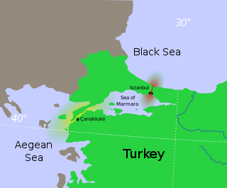
The Sea of Marmara, also known as the Sea of Marmora or the Marmara Sea, is a small inland sea located entirely within the borders of Turkey. It connects the Black Sea to the Aegean Sea via the Bosporus and Dardanelles straits, separating Turkey’s European and Asian sides. It has an area of 11,350 km2 (4,380 sq mi), and its dimensions are 280 km × 80 km. Its greatest depth is 1,370 m (4,490 ft).

Taksim Square, situated in Beyoğlu in the European part of Istanbul, Turkey, is a major tourist and leisure district famed for its restaurants, shops, and hotels. It is considered the heart of modern Istanbul, with the central station of the Istanbul Metro network. Taksim Square is also the location of the Republic Monument which was crafted by Pietro Canonica and inaugurated in 1928. The monument commemorates the 5th anniversary of the foundation of the Republic of Turkey in 1923, following the Turkish War of Independence.

Kartal is a municipality and district of Istanbul Province, Turkey. Its area is 38 km2, and its population is 483,418 (2022). It is located on the Asian side of the city, on the coast of the Marmara Sea between Maltepe and Pendik.

Ortaköy is a neighbourhood in the municipality and district of Beşiktaş, Istanbul Province, Turkey. Its population is 9,423 (2022). It is on the European shore of the Bosphorus. it was originally a small fishing village, known in Greek as Agios Fokas in the Byzantine period and then as Mesachorion.

Maltepe is a municipality and district of Istanbul Province, Turkey. Its area is 53 km2, and its population is 528,544 (2022). It is on the northern shore of the Sea of Marmara, adjacent to the Kadıköy district to the west, Kartal district to the east and Ataşehir district to the northwest. The mayor of Maltepe is Ali Kılıç (CHP).

Küçükçekmece, is a municipality and district of Istanbul Province, Turkey. Its area is 44 km2, and its population was 326,452 in 2022. It is 23 kilometers west of the city centre and lies next to Lake Küçükçekmece. Both the lake and land reside on the European shore of the Sea of Marmara. It is the second most populous district of Istanbul.

Public transport in Istanbul comprises a bus network, various rail systems, funiculars, and maritime services to serve the more than 15 million inhabitants of the city spread over an area of 5,712 km2.

Gebze, formerly known as Libyssa, is a municipality and district of Kocaeli Province, Turkey. Its area is 418 km2, and its population is 407,019 (2022). It is situated 65 km (30 mi) southeast of Istanbul, on the Gulf of Izmit, the eastern arm of the Sea of Marmara. Gebze is the largest district by population size in the province as of 2022, exceeding İzmit, the provincial capital.

Istanbul is the largest city in Turkey, serving as the country's economic, cultural and historic hub. The city straddles the Bosporus Strait, lying in both Europe and Asia, and has a population of over 15 million residents, comprising 19% of the population of Turkey. Istanbul is the most populous European city and the world's 15th largest city.

Bostancı is a neighbourhood in the municipality and district of Kadıköy, Istanbul Province, Turkey. Its population is 33,638 (2022). It is on the Anatolian side of Istanbul, on the shore of the Sea of Marmara. As the easternmost neighbourhood of the Kadıköy district; it borders Suadiye and Kozyatağı to the west, İçerenköy to the north, and Altıntepe to the east.

The Marmara Region is a geographical region of Turkey.

Line M1, officially referred to as the M1 Yenikapı–Atatürk Airport/Kirazlı metro line, also known as the Istanbul Light Metro, is a rapid transit line of the Istanbul Metro. It is colored red on the maps and route signs. Opened in 1989, it was the first rapid transit line in Istanbul and Turkey and its opening started the revival of mass-transit in Turkish cities.

The Yavuz Sultan Selim Bridge, also known as the Third Bosphorus Bridge, is a vehicular bridge over the Bosphorus strait, to the north of Istanbuls's two older suspension bridges, the 15 July Martyrs Bridge being the First Bosphorus Bridge and Fatih Sultan Mehmet Bridge the Second Bosphorus Bridge. The bridge is located near the entrance to the Black Sea from the Bosphorus strait, between Garipçe in Sarıyer on the European side and Poyrazköy in Beykoz on the Asian side.

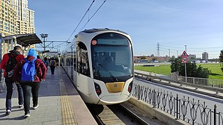
The Istanbul Tram is a modern tram system on the European side of Istanbul. The first section, the T1 opened in 1992, followed by the T2, which opened in 2006. In 2011, the T1 and T2 merged, with the line retaining the T1 name. The T4 and the T5 lines followed, opening in 2007 and 2021, respectively.

MV Mavi Marmara is a Comoros-flagged passenger ship, which was formerly owned and operated by İDO Istanbul Fast Ferries Co. Inc. on the line Sarayburnu, Istanbul-Marmara Island-Avşa Island in the Sea of Marmara. Built at the Golden Gate Shipyard by Turkish Shipbuilding Co. in 1994, the ship has a capacity of 1,080 passengers. It is best known for its participation in the Gaza Freedom Flotilla and the deadly confrontation that took place on it during the Gaza flotilla raid.

The Istanbul Canal is a project for an artificial sea-level waterway planned by Turkey in East Thrace, connecting the Black Sea to the Sea of Marmara, and thus to the Aegean and Mediterranean seas. Istanbul Canal would bisect the current European side of Istanbul and thus form an island between Asia and Europe. The new waterway would bypass the current Bosporus.

İzmit is a municipality and the capital district of Kocaeli Province, Turkey. Its area is 480 km2, and its population is 376,056 (2022). The capital of Kocaeli Province, it is located at the Gulf of İzmit in the Sea of Marmara, about 100 km (62 mi) east of Istanbul, on the northwestern part of Anatolia. Kocaeli Province had a population of 2,079,072 inhabitants in 2022, of whom approximately 1.2 million lived in the largely urban İzmit City metro area made up of Kartepe, Başiskele, Körfez, Gölcük, Derince and Sapanca. Unlike other provinces in Turkey, apart from Istanbul, the whole province is included within the municipality of the metropolitan center.

Kadıköy is the western terminal station on the M4 line of the Istanbul Metro. Located beneath Haydarpaşa Rıhtım Caddesi (Street) it is serviced by the M4 between 6:00 and 0:04. The station has two tracks serving an island platform. Kadıköy opened on 17 August 2012 along with fifteen other stations on the M4 line. The Turkish Prime Minister Recep Tayyip Erdoğan along with the Mayor of Istanbul, Kadir Topbaş and other members of government inaugurated the line from Kadıköy and boarded a train to Kartal.

Acıbadem is an underground station on the M4 line of the Istanbul Metro in the Acıbadem neighborhood of Kadıköy, Istanbul. Situated under the D.100 state highway, near Acıbadem Avenue. The station was opened on 17 August 2012 along with the Kadıköy-Kartal portion of the M4 line.
Marmara University Prof. Dr. Asaf Ataseven Hospital is a public hospital in Maltepe district of Istanbul, Turkey. It was opened in June 2020.


