Maroda

Last updated

Maroda
village
Maroda Gaon.jpg
Maroda
India Uttarakhand location map.svg
Red pog.svg
Maroda
Location in Uttarakhand, India
Coordinates: 30°06′36″N78°37′20″E / 30.109958°N 78.622305°E / 30.109958; 78.622305 Coordinates: 30°06′36″N78°37′20″E / 30.109958°N 78.622305°E / 30.109958; 78.622305
CountryFlag of India.svg  India
State Uttarakhand
Division Garhwal
District Pauri Garhwal
Population
  Total 750
Languages
  Official Hindi
  Spoken Garhwali
Time zone UTC+5:30 (IST)
This is the picture of maroda gaon. Maroda pic.jpg
This is the picture of maroda gaon.
Maroda View Maroda, kandwalsyun.jpg
Maroda View

Maroda is a village located in the Pauri Garhwal district of Uttarakhand, India. [1]

Uttarakhand State in Northern India

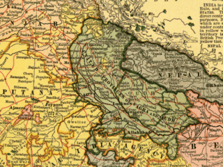
Uttarakhand, formerly known as Uttaranchal, is a state in the northern part of India. It is often referred to as the Devabhumi due to a large number of Hindu temples and pilgrimage centres found throughout the state. Uttarakhand is known for the natural environment of the Himalayas, the Bhabhar and the Terai. On 9 November 2000, Uttarakhand became the 27th state of the Republic of India, being created from the Himalayan districts of Uttar Pradesh. It borders Tibet Autonomous Region of China to the north; the Sudurpashchim Pradesh of Nepal to the east; the Indian states of Uttar Pradesh to the south and Himachal Pradesh to the west and north-west. The state is divided into two divisions, Garhwal and Kumaon, with a total of 13 districts. The interim capital of Uttarakhand is Dehradun, the largest city of the state, which is a railhead. The High Court of the state is located in Nainital.

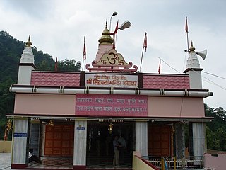
Maroda is located 9 km ahead of Devprayag on the way to Sabdar Khal and Pauri. It is situated in the laps of the mountains of Uttarakhand and on the foothills of the Jai Danda Nagraja Mandir, a Hindu temple dedicated to the Krishna.

Devprayag town in Uttarakhand, India

Devprayag is a town and a nagar panchayat (municipality) in Tehri Garhwal district in the state of Uttarakhand, India, and is one of the Panch Prayag of Alaknanda River where Alaknanda and Bhagirathi rivers meet and take the name Ganga.

Pauri Town in Uttarakhand, India

Pauri is a town and a municipal board in Pauri Garhwal district in the Indian state of Uttarakhand. Pauri is the seat of the Divisional Commissioner of the Garhwal Division. Beautiful valleys, azure sky, and deep gorges makes Pauri a well suited summer destination.

Krishna Major deity in Hinduism

Shree Krishna or simply Krishna is a major deity in Hinduism. He is worshipped as the eighth avatar of the god Vishnu and also as the supreme God in his own right. He is the god of compassion, tenderness, and love in Hinduism, and is one of the most popular and widely revered among Indian divinities. Krishna's birthday is celebrated every year by Hindus on Janmashtami according to the lunisolar Hindu calendar, which falls in late August or early September of the Gregorian calendar.

Maroda comes under the Pauri Garhwal district & Patti Kandwalsyun. The nearest hospitals, large markets, cinema halls and the government offices are all located in Pauri. Smaller markets can be found in the neighbouring areas like Devpryag, Sabdarkhal, and Sirala. Garhwali is the main dialect (language) spoken in the area.

Pauri Garhwal district District of Uttarakhand in India

District Pauri or Pauri Garhwal is situated in the state of Uttarakhand in Northern India with the town of Pauri as its headquarters. It lies between latitude 29.26 and 30.19 N and longitude 78.12 and 79.14 E. The maximum length from east to west is 103 km. and the maximum breadth from north to south about 100 km. Total geographical area of the district is 5,329 km2.

Garhwali language Central Pahari language belonging to the Northern Zone of Indo-Aryan languages

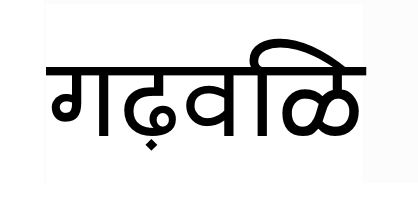
Garhwali language is a Central Pahari language belonging to the Northern Zone of Indo-Aryan languages. It is primarily spoken by over 2.5 million Garhwali people who are from the Garhwal Division of the northern Indian state of Uttarakhand in the Indian Himalayas.

Maroda is surrounded by the beautiful mountains & forest. The main water source is 1.5 km away from the village, which is called PANDHER, where fresh & crystal clear water comes out from mountains. Bus Station for Maroda is around 5 km away from the village, which is called DHAUDA, it is a common bus stand for the nearby villages as well.

Related Research Articles

Garhwal division Administrative division of Uttarakhand, India

Garhwal is the western region and administrative division of the Indian state of Uttarakhand which is home to the Garhwali people. Lying in the Himalayas, it is bounded on the north by Tibet, on the east by Kumaon region, on the south by Uttar Pradesh state, and on the northwest by Himachal Pradesh state. It includes the districts of Chamoli, Dehradun, Haridwar, Pauri Garhwal, Rudraprayag, Tehri Garhwal, and Uttarkashi. The people of Garhwal are known as Garhwali and speak the Garhwali language. The administrative center for Garhwal division is the town of Pauri. The Divisional Commissioner is the administrative head of the Division, and is a senior Indian Administrative Service officer. As the administrative head of the division, the Commissioner is overall incharge of the 7 districts in the Garhwal region of Uttarakhand, and is aided in his duties by an Additional Commissioner and the District Magistrates. Vinod Sharma is currently the Divisional Commissioner of the Garhwal Division.

Gairsain Town in Uttarakhand, India

Gairsain[ɡɛːrˈsɛːɳ] is a town and Nagar Panchayat in Chamoli district of Uttarakhand. Gairsain is situated at the eastern edge of vast Dudhatoli range, almost at the centre of Uttarakhand, India, at a distance of approximately 250 kilometres from Dehradun. It is easily accessible from both Garhwal and Kumaon, and in a way, acts as the bridge between the two regions. It is being considered as the future capital of Uttarakhand.

Rudraprayag district District in Uttarakhand, India

Rudraprayag district, is a district of Uttarakhand state of northern India. The district occupies an area of 2439 km². Rudraprayag town is the administrative headquarters of the district. The district is bounded by Uttarkashi District on the north, Chamoli District on the east, Pauri Garhwal District on the south, and Tehri Garhwal District on the south.

Garhwal District

Garhwal District is a former district of British India, in the Kumaon Division of the United Provinces, and had an area of 5,629 sq mi (14,580 km2). It later became a part of the Indian state of Uttar Pradesh, today it is part of the Indian state Uttarakhand.

Lansdowne, India City in Uttarakhand, India

Lansdowne, is a cantonment town in Pauri Garhwal district in the Indian state of Uttarakhand.

Gauchar Town in Uttarakhand, India

Gauchar is a Hill Town located in Karnaprayag tehsil within Chamoli district of Uttarakhand state in India. Gauchar is situated on the left bank of river Alaknanda and is en route the celebrated holy destination of Badrinath. Situated at an altitude of 800 metres (2,620 ft) above the sea level, Gauchar is surrounded by seven mountains. Gauchar is well known for its historic trade fair. This quiet little town is unique in terms of its geographical location and topography. Gauchar is located on one of the largest pieces of flatland in this mountainous region of Uttarakhand.

Kotdwar City in Uttarakhand, India

Kotdwar is a tehsil in Pauri Garhwal district in Indian state of Uttarakhand. Its old name was Khohdwar, which means the gateway of the river Khoh: as Kotdwar is located on the bank of river Khoh so it was named Kotdwar. It is situated in the south-western part of state and is one of the main entrance points in the state of Uttarakhand. Kotdwar Railway station, established in 1890 by the Britishers is one of the oldest railway stations of the country. Being the gateway of Himalayan Region, Kotdwar rail route was used for timber transportation from Himalayan Region. First Passenger train ran in the year 1901.

UNIYAL is a North Indian Garhwali Brahmin surname, mostly used in the Indian state of Uttarakhand. In Yamunotri, ritual duties such as the making and distribution of prasad (Sacrament) and the supervision of pujas are performed by the Uniyal family of pujaris (priests). They are part of the top four (chauthogi) sub-classes of Brahmins in Garhwal, others being Dangwal, Dobhal and Bahuguna.

Srinagar, Uttarakhand city in Uttarakhand, India

Not to be confused with another Srinagar, the summer capital of Jammu and Kashmir

Ramganga is a tributary of the river Ganga, originating in Uttarakhand state, India.

Hemwati Nandan Bahuguna Garhwal University

Hemvati Nandan Bahuguna Garhwal University is a Public Central University located in Srinagar town in the Pauri Garhwal district of Uttarakhand state in northern India. Named after Hemvati Nandan Bahuguna, former Chief Minister of Uttar Pradesh, the university is residential cum affiliating with jurisdiction over Garhwal region. It is on the banks of the river Alaknanda in the mid-Himalayas.

1999 Chamoli earthquake 1999 earthquake in India

The 1999 Chamoli earthquake occurred on 29 March in the Chamoli district in the Indian state of Uttar Pradesh. The earthquake was the strongest to hit the foothills of the Himalayas in more than ninety years. Approximately 103 people died in the earthquake.

Garhwali people

Garhwali people are an Indo-Aryan ethno-linguistic group who primarily live in the Garhwal Himalayas of the northern Indian state of Uttarakhand and speak the Indo-Aryan Garhwali language. Any person who has ancestral Garhwali roots or lives in Garhwal and has a Garhwali heritage is called a Garhwali. There are around 8.1 million Garhwali people worldwide.

Satpuli Town in Uttarakhand, India

Satpuli is a town on Meerut-Pauri highway, located at a distance of approximately 50 kilometres from Kotdwar and 50 kilometers from Pauri, in Pauri Garhwal district of Uttarakhand.

Thalisain Town in Uttarakhand, India

Thalisain is a town and tehsil of Pauri Garhwal district in the North Indian state of Uttarakhand. At an altitude of 1690 metres from sea level, it is situated on a gentle slope above the right bank of Nayaar (East) river. It is in the southwestern foothills of Dudhatoli Range and at a distance of 83 kilometers from Pauri town and 95 kilometers from Gairsain, the future capital of Uttarakhand.

Veer Chandra Singh Garhwali Uttarakhand University of Horticulture & Forestry

Veer Chandra Singh Garhwali Uttarakhand University of Horticulture & Forestry, formerly Uttarakhand University of Horticulture and Forestry (UUHF), is a state university located in north Indian state of Uttarakhand. University has two campuses, one is in Bharsar town of Pauri Garhwal district and other is in Ranichauri town of Tehri Garhwal district.

Dudhatoli

Dudhatoli is a middle Himalayan mountain range/forest running approximately 25 km in a North-South direction, starting near Thalisain tehsil of Pauri Garhwal district in Uttarakhand, with Gairsain in Chamoli district being its western limit and Syoli-Khand region in Pauri its northern-most spur.

References