
Alki Point is a point jutting into Puget Sound, the westernmost landform in the West Seattle district of Seattle, Washington. Alki is the peninsular neighborhood on Alki Point. Alki was the original settlement in what was to become the city of Seattle. It was part of the city of West Seattle from 1902 until that city's annexation by Seattle in 1907.
The Seattle Liberation Front, or SLF, was a radical anti-Vietnam War movement, based in Seattle, Washington, in the United States. The group, founded by the University of Washington visiting philosophy professor and political activist Michael Lerner, carried out its protest activities from 1970 to 1971. The most famous members of the SLF were the "Seattle Seven," who were charged with "conspiracy to incite a riot" in the wake of a violent protest at a courthouse. The members of the Seattle Seven were Lerner, Michael Abeles, Jeff Dowd, Joe Kelly, Susan Stern, Roger Lippman and Charles Marshall III.

Queen Anne is a neighborhood and geographic feature in Seattle, Washington, United States, located northwest of downtown. Queen Anne covers an area of 7.3 square kilometers (2.8 sq mi), and has a population of about 28,000. It is bordered by Belltown to the south, Lake Union to the east, the Lake Washington Ship Canal to the north and Interbay to the west.
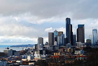
Kerry Park is a small public park and viewpoint on the south slope of Queen Anne Hill in Seattle, Washington, United States. It overlooks Downtown Seattle and is located along West Highland Drive between 2nd Avenue West and 3rd Avenue West. The park's view is considered to offer the most iconic views of the city skyline, with the Space Needle prominent at the center, Elliott Bay to the west, and Mount Rainier in the background.
Magnuson Park is a park in the Sand Point neighborhood of Seattle, Washington, United States. At 350 acres (140 ha) it is the second-largest park in Seattle, after Discovery Park in Magnolia. Magnuson Park is located at the site of the former Naval Station Puget Sound, on the Sand Point peninsula with Pontiac and Wolf bays that juts into Lake Washington in northeast Seattle.

Washington Park is a public park in Seattle, Washington, United States, most of which is taken up by the Washington Park Arboretum, a joint project of the University of Washington, the Seattle Parks and Recreation, and the nonprofit Arboretum Foundation. Washington Park also includes a playfield and the Seattle Japanese Garden in its southwest corner. To the north is Union Bay; to the west are Montlake and Madison Valley; to the south is the Washington Park neighborhood; and to the east is the Broadmoor Golf Club.
Dr. Jose Rizal Park is a 9.6 acre park on the west slope of Beacon Hill in Seattle, Washington. The land, condemned by the city in 1917 for engineering purposes, was acquired by the Parks Department in 1971, and the park was dedicated eight years later. The park is named after José Rizal, the de facto national hero of the Philippines.

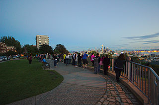
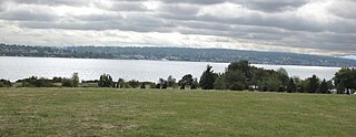
Hamilton Viewpoint is a 16.9-acre (6.8 ha) public park in the West Seattle neighborhood of Seattle, Washington, United States. It was acquired by the city in 1914 and became a park 4 years later. Its namesake is Rupert L. Hamilton, a noted figure in the West Seattle community who helped establish the park. It had previously been known as West Side Park and Duwamish Head Park.

Heceta Head Light is a lighthouse on the Oregon Coast 13 miles (21 km) north of Florence, and 13 miles (21 km) south of Yachats in the United States. It is located at Heceta Head Lighthouse State Scenic Viewpoint, a state park, midway up a 205-foot-tall (62 m) headland. Built in 1894, the 56-foot (17 m)-tall lighthouse shines a beam visible for 21 nautical miles, making it the strongest light on the Oregon Coast.

Betty Bowen (1918–1977), was an American journalist and art promoter. She was born in Kent, Washington, and earned an English degree from the University of Washington. She worked briefly as a reporter for The Seattle Times, and later as women's editor for the Seattle Star. She was married to John Bowen, captain of an AT&T ship that laid undersea cables.

Seattle is a seaport city on the West Coast of the United States. It is the seat of King County, Washington. With a 2023 population of 755,078 it is the most populous city in both the state of Washington and the Pacific Northwest region of North America, and the 18th-most populous city in the United States. The Seattle metropolitan area's population is 4.02 million, making it the 15th-largest in the United States. Its growth rate of 21.1% between 2010 and 2020 made it one of the country's fastest-growing large cities.

Bald Peak State Scenic Viewpoint is a state park located atop Bald Peak located in Yamhill County, in the United States. The day use only park offers picnic tables and a hiking trail for views of the Willamette Valley and the Cascade Range. The state of Oregon acquired the 26 acres (11 ha) in 1931 after Yamhill and Washington counties requested a park from the state.

Cline Falls State Scenic Viewpoint is a state park near Redmond, Oregon, United States. It is located on the Deschutes River. The park covers 9 acres (36,000 m2). It is administered by the Oregon Parks and Recreation Department.

Face Rock State Scenic Viewpoint is a state park in Bandon, Oregon, United States, administered by the Oregon Parks and Recreation Department. The rocks and tidal flats adjacent to the park form part of the Oregon Islands National Wildlife Refuge. More than 300 species of birds frequent the area.

Rocky Creek State Scenic Viewpoint is a state park in Lincoln County in northwestern Oregon, United States. Administered by the Oregon Parks and Recreation Department, the 59-acre (24 ha) park lies along a bluff between Whale Cove and Rocky Creek. The park extends south along the Otter Crest Loop Road to the Rocky Creek Bridge.

Parsons Gardens Park is a 0.4-acre (0.16 ha) city park in the Queen Anne neighborhood of Seattle, Washington. It was called by Fodor's a "a prim urban oasis", and by another guide a "secret garden for non-tourists". The park sits at one end of West Highland Drive, across the street from Betty Bowen Viewpoint and not far from better-known Kerry Park.

Windy Ridge is a ridge and eponymous Forest Highway in the Mount St. Helens National Volcanic Monument. The ridge goes between Windy Pass and Independence Pass, 1 mile (1.6 km) east of Spirit Lake. Several road guides list Windy Ridge Road (NF-99) as one of the best roads in Washington State due to its good pavement, good views, and winding "sweeper" curves enjoyable to many drivers and motorcycle riders. At the end of the road at 4,200 feet (1,300 m) elevation, at 46°15′00″N122°08′14″W above Spirit Lake, there is a viewpoint into the St. Helens crater.

Plymouth Pillars Park is a public park in Seattle, in the U.S. state of Washington.

