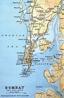
Salsette Island is an island in Konkan division of the state of Maharashtra, along India's west coast. Administratively known as Greater Mumbai, the Mumbai Suburban district, Mira Bhayander and a portion of Thane district lie within it, making it very populous and one of the most densely populated islands in the world. It has a population of more than 20 million inhabitants living on an area of about 619 square kilometres (239 sq mi).

Mumbai Harbour, is a natural deep-water harbour in the southern portion of the Ulhas River estuary. The narrower, northern part of the estuary is called Thana Creek. The harbour opens to the Arabian Sea to the south. The historical island of Elephanta is one of the six islands that lie in the harbour.

The Middle Ground Coastal Battery is a heritage site of an antique coastal artillery battery managed by the Indian Navy on an islet off the coast of Mumbai, India. It is situated on Middle Ground isle in Mumbai Harbour, a few hundred metres away from the Gateway of India, in Thane Creek.

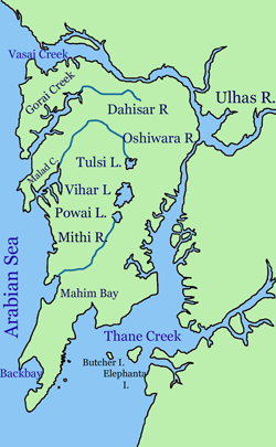
Gorai ([ɡoɾaːi]) is a village at Dharavi Bhet, in Mumbai, India. It is located on the North-western part of the island of Salsette. Gorai is accessed more usually by a ferry crossing the Manori Creek and Gorai creek or otherwise by the overland route through Bhayander. Gorai is bordered by the villages of Manori and Uttan, Pali, Chowk, Dongri, Tarodi, Rai, Morva and Murdhe.
Mumbai (Bombay) is India's most populous city with a population of 20 Million. It is located on Salsette Island off the coast of Maharashtra. The original Seven Islands of Bombay were merged by the British in the 18th century, to form one large island.

Marve Beach is located in the Western Suburb of Malad in the city of Mumbai, India.
Madh Island is a group of several quaint fishing villages and farmlands in northern Mumbai.
Willingdon Island is the largest artificial island in India, which forms part of the city of Kochi, in the state of Kerala. Much of the present Willingdon Island was claimed from the Vembanadu Lake, filling in dredged soil around a previously existing, but tiny, natural island. Willingdon Island is significant as the home for the Port of Kochi as well as the Kochi Naval Base, the Southern Naval Command of the Indian Navy, Plant Quarantine station, Custom House Cochin and Central Institute of Fisheries Technology, a constituent unit of Indian Council of Agricultural Research.
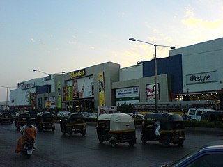
Malad is a suburb located in North Mumbai. Malad has a railway station on the Western line of the Mumbai Suburban Railway, lying between Kandivali station to the north and Goregaon station to the south. The railway tracks of the Western Line divide Malad into Malad (West) and Malad (East). It has a large Gujarati and Marathi population. Also located in Malad is a prominent office commercial space extending from the back of the two prominent shopping malls Inorbit Mall & Infiniti Mall. Marve Beach and Aksa Beach are Located in Malad.

Manori is a village located on Dharavi Bet in northern Mumbai, India. It is known for its beach and the Manori Creek.

Navy Nagar is a cantonment area in Mumbai, India, and was established in 1796. The area is owned and managed solely by the Indian Navy and entry to this area is highly restricted. Entry and exit points to the area are heavily manned by Naval Police.

Malad Creek or Marve Creek is a creek in north-west Mumbai. Located west of Malad, the Oshiwara River drains into it. To the west is Madh Island, and to the east lies Versova. Earlier it was surrounded by a 1,000-acre (4.0 km2) area of mangroves. But now this area has shrunk to 400 acres (1.6 km2) as the real estate prices in Malad went up. Malad creek is 5 km in length.

Aksa Beach is a popular beach and a vacation spot in Aksa village in Malad, Mumbai, India. It is situated close to Marvé Beach. It is a popular weekend destination and is dotted with many private cottages and hotels, some of which are rented out to tourists and visitors. Aksa beach also happens to be one of the cleanest beaches in the city of Mumbai

Okha is a coastal town in Devbhoomi Dwarka district of Gujarat state in India. It has a sea port. Dwarka situated some 30 km south and Bet Dwarka island situated 2.9 km across a small creek from Okha port are a major Hindu pilgrimage sites due to a temple dedicated to Krishna.

Anjediva Island is an Indian island in the Arabian Sea. It sits off the coast of Canacona, Goa. It is politically part of Goa state, geographically the nearest mainland is the coastal Kanara subregion of Carnataca.
INS Dweeprakshak is a naval base of the Southern Naval Command of the Indian Navy located on Kavaratti island in the Lakshadweep archipelago. It was commissioned on 30 April 2012.

INS Valsura is a "stone frigate" of the Indian Navy in Jamnagar, Gujarat. A premier technological training institution, it houses the Electrical school of the Indian Navy.
Dharavi Island is an island situated at the mouth of Vasai Creek on the western side of Salsette Island, within the city of Mumbai, India. Dharavi Island comprises six villages, Dongri, Uttan, Pali, Chowk, Gorai, and Manori.