
Towson is an unincorporated community and a census-designated place in Baltimore County, Maryland, United States. The population was 55,197 as of the 2010 census. It is the county seat of Baltimore County and the second-most populous unincorporated county seat in the United States.

Victorian architecture is a series of architectural revival styles in the mid-to-late 19th century. Victorian refers to the reign of Queen Victoria (1837–1901), called the Victorian era, during which period the styles known as Victorian were used in construction. However, many elements of what is typically termed "Victorian" architecture did not become popular until later in Victoria's reign, roughly from 1850 and later. The styles often included interpretations and eclectic revivals of historic styles (see Historicism). The name represents the British and French custom of naming architectural styles for a reigning monarch. Within this naming and classification scheme, it followed Georgian architecture and later Regency architecture, and was succeeded by Edwardian architecture.

Baltimore City College, known colloquially as City,City College, and B.C.C., is a college preparatory school with a liberal arts focus and selective admissions criteria located in Baltimore, Maryland. Opened in October 1839, B.C.C. is the third-oldest active public high school in the United States. City College is a public exam school and an International Baccalaureate World School at which students in the ninth and tenth grades participate in the IB Middle Years Programme while students in the eleventh and twelfth grades participate in the IB Diploma Programme. The school is situated on a 38 acres (0.15 km2) hill-top campus located in the Coldstream-Homestead-Montebello neighborhood in Northeast Baltimore. The main campus building, a designated National Historic Landmark, is constructed of granite and limestone in a Collegiate Gothic architectural style and features a 200-foot-tall Gothic tower.

Uptown is one of Chicago, Illinois’ 77 community areas. Uptown's boundaries are Foster Avenue on the north; Lake Michigan on the east; Montrose, and Irving Park on the south; Ravenswood, and Clark on the west. To the north is Edgewater, to the west is Lincoln Square, and to the south is Lake View.

Power Plant Live! is a collection of bars, restaurants and other businesses in the Inner Harbor section of downtown Baltimore, Maryland. It was developed by The Cordish Companies and opened in phases during 2001, 2002, and 2003. The entertainment complex gets its name from the nearby "Power Plant" building, three blocks south on municipal Pier 4 on East Pratt Street facing the Inner Harbor, which was also later re-developed by Cordish.
Robert Cary Long Jr. (1810–1849) was the son of a late 18th Century - early 19th Century famous architect Robert Cary Long Sr. of Baltimore, Maryland and was himself a well-known 19th Century architect. Like his father, Cary was based in Baltimore.
The music of Baltimore, the largest city in Maryland, can be documented as far back as 1784, and the city has become a regional center for Western classical music and jazz. Early Baltimore was home to popular opera and musical theatre, and an important part of the music of Maryland, while the city also hosted several major music publishing firms until well into the 19th century, when Baltimore also saw the rise of native musical instrument manufacturing, specifically pianos and woodwind instruments. African American music existed in Baltimore during the colonial era, and the city was home to vibrant black musical life by the 1860s. Baltimore's African American heritage to the start of the 20th century included ragtime and gospel music. By the end of that century, Baltimore jazz had become a well-recognized scene among jazz fans, and produced a number of local performers to gain national reputations. The city was a major stop on the African American East Coast touring circuit, and it remains a popular regional draw for live performances. Baltimore has produced a wide range of modern rock, punk and metal bands and several indie labels catering to a variety of audiences.

St. Charles College was a minor seminary in Catonsville, Maryland, originally located in Ellicott City, Maryland.
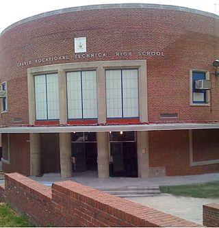
Carver Vocational-Technical High School – fully George Washington Carver Vocational-Technical High School – also known as Carver Vo-Tech, is a public vocational-technical high school located in the western part of Baltimore, Maryland, United States and part of the Baltimore City Public Schools system.

Windsor Mill Road is a road that runs through parts of Baltimore, Maryland and its western suburb Woodlawn. The road starts as a one-way street named Edgewood Street, then makes a slight left corner and becomes Windsor Mill Road. The road, which is approximately 7½ miles in length, runs parallel to nearby Liberty Road and Security Boulevard, and is often used as an alternative to these routes. Though Windsor Mill Road has no interchange with the Baltimore Beltway, it crosses over the highway, and this point is frequently mentioned in traffic reports.
Howard Street is a major north-south street through the central part of the city of Baltimore, Maryland. About 2+1⁄2 miles (4 km) long, the street begins at the north end of I-395 near Oriole Park at Camden Yards and ends near Johns Hopkins University, where it splits. To the right, it becomes Art Museum Drive, the one-block home of the Baltimore Museum of Art. To the left, it becomes San Martin Drive, which winds road along the western perimeter of the Johns Hopkins University campus and ends at University Parkway. Howard Street is named in honor of former Maryland governor John Eager Howard. Two other streets in Baltimore, John and Eager Streets, are also named after him.
St. Paul Street and Calvert Street are a one-way pair of streets in Downtown Baltimore and areas north. The streets, which are part of Maryland Route 2, are two of Baltimore's best-known streets in the downtown area.

The Belvedere is a Beaux Arts style building in Baltimore, Maryland. Designed by the Boston architectural firm of Parker and Thomas and built in 1902–1903, the Belvedere is a Baltimore City Landmark at the southeast corner of North Charles Street, facing north on East Chase Street in the city's fashionable Mount Vernon-Belvedere-Mount Royal neighborhood. In 1991 it was converted into condominiums, though areas remain open to the public.

University of Maryland Rehabilitation & Orthopaedic Institute is a rehabilitation hospital located along the border of the Forest Park neighborhood of northwest Baltimore City and Woodlawn in Maryland. It lies on and is incorporated into the historic hospital building and grounds of the former James Lawrence Kernan Hospital. The hospital is now part of the University of Maryland Medical System, on the campus of the University of Maryland at Baltimore.

Hotel Kernan, also known as the Congress Hotel, is a historic hotel located at Baltimore, Maryland, United States. It is a six-story plus mansard roof, French Renaissance Revival-style structure detailed in brick and terra cotta. It is constructed of steel and reinforced concrete and is "U"-shaped in plan. It was designed in 1903 by Philadelphia architect John Allen for theatrical impresario James Lawrence Kernan (1838-1912), who lived at the hotel until his death in 1912.

Hendler Creamery is a historic industrial complex in Jonestown, Baltimore, Maryland. Since it spans an entire block it has addresses at 1100 E. Baltimore St. and 1107 E. Fayette St. "The Hendler Creamery is historically significant for its contribution to the broad patterns of history in three areas of significance: transportation, performing arts, and industry."
James Lawrence Kernan (1838–1912) was a theater manager and philanthropist based in Baltimore, Maryland.

War Memorial Plaza is a public square, small park and space in Downtown Baltimore between City Hall and the War Memorial Building, between Holliday Street on the west, East Fayette Street on the south, North Gay Street on the east, and East Lexington Street on the north.

Paul Johannes Pelz was a German-American architect, best known as the main architect of the Library of Congress in Washington DC.

Albert L. Harris was an American architect who worked primarily in Washington, D.C. He was born in Wales and emigrated to the United States as a young child. He worked for architectural firms in Chicago and Baltimore and then Washington, where he also obtained an architectural degree from George Washington University. He was a part-time professor there while also working for the US Navy and then the city of Washington where he served as the city's Municipal Architect from 1921 until his death in 1933. A number of his works are listed on the National Register of Historic Places (NRHP).