Saher Stadium is a multi-purpose stadium in Tovuz, Azerbaijan. It is currently used mostly for football matches and is the home stadium of PFC Turan Tovuz. The stadium holds 6,800 people.
Kaczyce is a village in the administrative district of Gmina Pęcław, within Głogów County, Lower Silesian Voivodeship, in south-western Poland.
Osaka Medical College is a private university in Takatsuki, Osaka, Japan. The precursor of the school was founded in 1927, and it was chartered as a university in 1946.

Grodziszcze is a village in the administrative district of Gmina Stoszowice, within Ząbkowice Śląskie County, Lower Silesian Voivodeship, in south-western Poland. Prior to 1945 it was in Germany and called Lampersdorf.
Huta is a village in the administrative district of Gmina Bełchatów, within Bełchatów County, Łódź Voivodeship, in central Poland.
Górki is a village in the administrative district of Gmina Złoczew, within Sieradz County, Łódź Voivodeship, in central Poland.
Lipianki is a village in the administrative district of Gmina Ujazd, within Tomaszów Mazowiecki County, Łódź Voivodeship, in central Poland. It lies approximately 5 kilometres (3 mi) north-west of Ujazd, 16 km (10 mi) north-west of Tomaszów Mazowiecki, and 34 km (21 mi) south-east of the regional capital Łódź.
Grobelki is a village in the administrative district of Gmina Urszulin, within Włodawa County, Lublin Voivodeship, in eastern Poland.
Dwernik is a village in the administrative district of Gmina Lutowiska, within Bieszczady County, Subcarpathian Voivodeship, in south-eastern Poland, close to the border with Ukraine. It lies approximately 8 kilometres (5 mi) south-west of Lutowiska, 26 km (16 mi) south of Ustrzyki Dolne, and 102 km (63 mi) south-east of the regional capital Rzeszów.
Wojciechówka is a village in the administrative district of Gmina Policzna, within Zwoleń County, Masovian Voivodeship, in east-central Poland.
Szyszynek is a village in the administrative district of Gmina Ślesin, within Konin County, Greater Poland Voivodeship, in west-central Poland. It lies approximately 6 kilometres (4 mi) north of Ślesin, 22 km (14 mi) north of Konin, and 93 km (58 mi) east of the regional capital Poznań.
Bogdanowo is a village in the administrative district of Gmina Oborniki, within Oborniki County, Greater Poland Voivodeship, in west-central Poland. It lies approximately 3 kilometres (2 mi) south of Oborniki and 27 km (17 mi) north of the regional capital Poznań.
Chrząstówko is a village in the administrative district of Gmina Człuchów, within Człuchów County, Pomeranian Voivodeship, in northern Poland. It lies approximately 10 kilometres (6 mi) west of Człuchów and 124 km (77 mi) south-west of the regional capital Gdańsk.
Chrząstowo is a village in the administrative district of Gmina Człuchów, within Człuchów County, Pomeranian Voivodeship, in northern Poland. It lies approximately 10 kilometres (6 mi) west of Człuchów and 124 km (77 mi) south-west of the regional capital Gdańsk.
Poganice is a village in the administrative district of Gmina Potęgowo, within Słupsk County, Pomeranian Voivodeship, in northern Poland. It lies approximately 6 kilometres (4 mi) south-west of Potęgowo, 25 km (16 mi) east of Słupsk, and 80 km (50 mi) west of the regional capital Gdańsk.

Shawan District is a district of the city of Leshan, Sichuan Province, China.
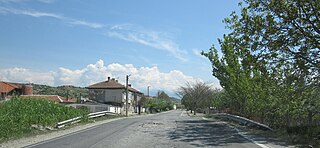
Marino pole is a village in Petrich Municipality, in Blagoevgrad Province, Bulgaria.

Allika is a village in Kuusalu Parish, Harju County in northern Estonia.
Lalli is a village in Muhu Parish, Saare County in western Estonia.
The Du is a river mainly in northwestern Hubei Province, China with sources in Shaanxi Province. It is the principal right-bank tributary of the Han River. It is interrupted by the Pankou and Huanglongtan Dams.


