
Palenque, also anciently known in the Itza Language as Lakamha, was a Maya city state in southern Mexico that perished in the 8th century. The Palenque ruins date from ca. 226 BC to ca. 799 AD. After its decline, it was overgrown by the jungle of cedar, mahogany, and sapodilla trees, but has since been excavated and restored. It is located near the Usumacinta River in the Mexican state of Chiapas, about 130 km south of Ciudad del Carmen, 150 meters (490 ft) above sea level. It averages a humid 26°C (79°F) with roughly 2,160 millimeters (85 in) of rain a year.
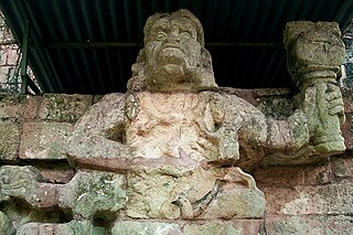
Copán is an archaeological site of the Maya civilization in the Copán Department of western Honduras, not far from the border with Guatemala. This ancient Maya city mirrors the beauty of the physical landscape in which it flourished—a fertile, well-watered mountain valley in western Honduras at an elevation of 600 meters above mean sea level. It was the capital city of a major Classic period kingdom from the 5th to 9th centuries AD. The city was in the extreme southeast of the Mesoamerican cultural region, on the frontier with the Isthmo-Colombian cultural region, and was almost surrounded by non-Maya peoples.

The Pyramid of Djoser, or Step Pyramid of Djoser, is an archaeological site in the Saqqara necropolis, Egypt, northwest of the ruins of Memphis. The 6-tier, 4-sided structure is the earliest colossal stone building in Egypt. It was built in the 27th century BC during the Third Dynasty for the burial of Pharaoh Djoser. The pyramid is the central feature of a vast mortuary complex in an enormous courtyard surrounded by ceremonial structures and decoration. Its architect was Imhotep, chancellor of the pharaoh and high priest of the god Ra.

Tikal is the ruin of an ancient city, which was likely to have been called Yax Mutal, found in a rainforest in Guatemala. It is one of the largest archeological sites and urban centers of the pre-Columbian Maya civilization. It is located in the archeological region of the Petén Basin in what is now northern Guatemala. Situated in the department of El Petén, the site is part of Guatemala's Tikal National Park and in 1979 it was declared a UNESCO World Heritage Site.

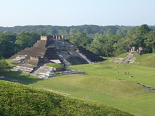
Altun Ha is the name given to the ruins of an ancient Mayan city in Belize, located in the Belize District about 50 kilometres (31 mi) north of Belize City and about 10 kilometres (6.2 mi) west of the shore of the Caribbean Sea. The site covers an area of about 8 square kilometres (3.1 sq mi).

Lamanai is a Mesoamerican archaeological site, and was once a major city of the Maya civilization, located in the north of Belize, in Orange Walk District. The site's name is pre-Columbian, recorded by early Spanish missionaries, and documented over a millennium earlier in Maya inscriptions as Lam'an'ain. Lamanai is renowned for its exceptionally long occupation spanning three millennia, beginning in the Early Preclassic Maya period and continuing through the Spanish and British Colonial periods, into the 20th century. Unlike most Classic-period sites in the southern Maya lowlands, Lamanai was not abandoned at the end of the 10th century AD.

The pyramid of Menkaure is the smallest of the three main Pyramids of Giza, located on the Giza Plateau in the southwestern outskirts of Cairo, Egypt. It is thought to have been built to serve as the tomb of the Fourth Dynasty Egyptian Pharaoh Menkaure.

Lintel 24 is the designation given by modern archaeologists to an ancient Maya limestone carving from Yaxchilan, in modern Chiapas, Mexico. The lintel dates to about 723-6 AD, placing it within the Maya Late Classic period. The text of Maya hieroglyphics Found in Mesoamerica The alleged ritual depicting the ruler, Shield Jaguar, holding what resembles a torch while his consort, Lady Xoc, pulls a rope studded with what are now believed to be obsidian shards through her tongue possibly to conjure a vision serpent.

Cerros is an Eastern Lowland Maya archaeological site in northern Belize that functioned from the Late Preclassic to the Postclassic period. The site reached its apogee during the Mesoamerican Late Preclassic and at its peak, it held a population of approximately 1,089 people. The site is strategically located on a peninsula at the mouth of the New River where it empties into Chetumal Bay on the Caribbean coast. As such, the site had access to and served as an intermediary link between the coastal trade route that circumnavigated the Yucatán Peninsula and inland communities. The inhabitants of Cerros constructed an extensive canal system and utilized raised-field agriculture.

Maya architecture spans several thousands of years, several eras of political change, and architectural innovation before the Spanish colonization of the Americas. Often, the buildings most dramatic and easily recognizable as creations of the Maya peoples are the step pyramids of the Terminal Preclassic Maya period and beyond. Based in general Mesoamerican architectural traditions, the Maya utilized geometric proportions and intricate carving to build everything from simple houses to ornate temples. This article focuses on the more well-known pre-classic and classic examples of Maya architecture. The temples like the ones at Palenque, Tikal, and Uxmal represent a zenith of Maya art and architecture. Through the observation of numerous elements and stylistic distinctions, remnants of Maya architecture have become an important key to understanding their religious beliefs and culture as a whole.

The Pyramid of the Magician is a Mesoamerican step pyramid located in the ancient Mayan city of Uxmal, Mexico. It is the tallest and most recognizable structure in Uxmal.

El Zotz is a Mesoamerican archaeological site of the pre-Columbian Maya civilization, located in the Petén Basin region around 20 kilometres (12 mi) west of the major center of Tikal and approximately 26 kilometres (16 mi) west of Uaxactun. It is so called because of the large number of bats living in caves in the nearby cliffs. The site is located within the San Miguel la Palotada National Park bordering the Tikal National Park in the present-day department of Petén, Guatemala. It is a large Classic Period site and contains many unexcavated mounds and ruins.

The Pre-Columbian Belize history is the period from initial indigenous presence, across millennia, to the first contacts with Europeans - the Pre-Columbian or before Columbus period - that occurred on the region of the Yucatán Peninsula that is present day Belize.
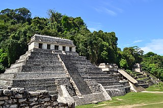
The Temple of the Inscriptions is the largest Mesoamerican stepped pyramid structure at the pre-Columbian Maya civilization site of Palenque, located in the modern-day state of Chiapas, Mexico. The structure was specifically built as the funerary monument for K'inich Janaab' Pakal, ajaw or ruler of Palenque in the 7th century, whose reign over the polity lasted almost 70 years. Construction of this monument commenced in the last decade of his life, and was completed by his son and successor K'inich Kan B'alam II. Within Palenque, the Temple of the Inscriptions is located in an area known as the Temple of the Inscriptions’ Court and stands at a right angle to the Southeast of the Palace. The Temple of the Inscriptions has been significant in the study of the ancient Maya, owing to the extraordinary sample of hieroglyphic text found on the Inscription Tablets, the impressive sculptural panels on the piers of the building, and the finds inside the tomb of Pakal.
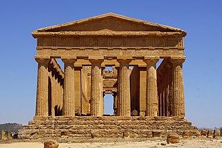
The Valle dei Templi, or Valley of the Temples, is an archaeological site in Agrigento, Sicily. It is one of the most outstanding examples of Magna Graecia art and architecture, and is one of the main attractions of Sicily as listed in 1997. Much of the excavation and restoration of the temples was due to the efforts of archaeologist Domenico Antonio Lo Faso Pietrasanta (1783–1863), who was the Duke of Serradifalco from 1809 through 1812. During the 20th century, the archeological excavation was mainly funded by Captain Alexander Hardcastle. He permitted excavations within the archaeological park including the straightening of the eight columns on the south side of the Temple of Heracles. For his contributions to archaeology he was made an honorary citizen of the city of Agrigento and was granted in 1928 the rank of Commander of the Order of the Crown of Italy.

The Mundo Perdido is the largest ceremonial complex dating from the Preclassic period at the ancient Maya city of Tikal, in the Petén Department of northern Guatemala. The complex was organised as a large E-Group astronomical complex consisting of a pyramid aligned with a platform to the east that supported three temples. The Mundo Perdido complex was rebuilt many times over the course of its history. By AD 250–300 its architectural style was influenced by the great metropolis of Teotihuacan in the Valley of Mexico, including the use of the talud-tablero form. During the Early Classic period the Mundo Perdido became one of the twin foci of the city, the other being the North Acropolis. From AD 250 to 378 it may have served as the royal necropolis. The Mundo Perdido complex was given its name by the archaeologists of the University of Pennsylvania.
Comalcalco is an ancient Maya archaeological site in the State of Tabasco, Mexico, adjacent to the modern city of Comalcalco and near the southern coast of the Gulf of Mexico. It is the only major Maya city built with bricks rather than limestone masonry and was the westernmost city of the Maya civilisation. Covering an area of 7 km2 (2.7 sq mi), Comalcalco was founded in the Late Classic period and may have been a satellite or colony of Palenque based on architectural similarities between the two. The city was a center of the Chontal Maya people.

The North Acropolis of the ancient Maya city of Tikal in Guatemala is an architectural complex that served as a royal necropolis and was a centre for funerary activity for over 1300 years. The acropolis is located near the centre of the city and is one of the most studied of Maya architectural complexes. Excavations were carried out from 1957 to 1969 by the University of Pennsylvania, directed by Edwin M. Shook and William Coe.

The Tomb of the Red Queen is a burial chamber containing the remains of a noblewoman, perhaps Lady Ix Tz'akbu Ajaw, and two servants, located inside Temple XIII in the ruins of the ancient Maya city of Palenque, now the Palenque National Park, in the Chiapas state in southern Mexico. It has been dated to between 600 and 700 AD. The tomb was discovered in 1994 by the Mexican archeologist Fanny Lopez Jimenez after being commissioned to perform routine stabilization work on a set of temple stairs by the local Archaeologist Arnoldo Gonzalez Cruz. It takes its popular name from the fact that the remains of the noblewoman and the objects in the sarcophagus were covered with bright red cinnabar powder when the tomb was discovered.
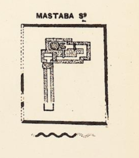
S 9 is the modern name given to a monumental ancient Egyptian tomb complex at Abydos in Egypt. The tomb is most likely royal and dates to the mid-13th Dynasty, during the late Middle Kingdom. Finds from the area of the tomb indicate that S9 suffered extensive, state-sanctioned stone and grave robbing during the Second Intermediate Period, only a few decades after its construction, as well as during the later Roman and Coptic periods. Although no direct evidence was found to determine the tomb owner, strong indirect evidence suggest that the neighbouring and slightly smaller tomb S10 belongs to pharaoh Sobekhotep IV. Consequently, S9 has been tentatively attributed by the Egyptologist Josef W. Wegner to Sobekhotep IV's predecessor and brother, Neferhotep I . According to Wegner, the tomb might originally have been capped by a pyramid.

