
Habitat conservation is a management practice that seeks to conserve, protect and restore habitats and prevent species extinction, fragmentation or reduction in range. It is a priority of many groups that cannot be easily characterized in terms of any one ideology.

The National Estuarine Research Reserve System is a network of 30 protected areas established by partnerships between the National Oceanic and Atmospheric Administration (NOAA) and coastal states. The reserves represent different biogeographic regions of the United States. The National Estuarine Research Reserve System protects more than 1.3 million acres of coastal and estuarine habitats for long-term research, water-quality monitoring, education, and coastal stewardship.
Natural Resources Conservation Service (NRCS), formerly known as the Soil Conservation Service (SCS), is an agency of the United States Department of Agriculture (USDA) that provides technical assistance to farmers and other private landowners and managers.

The Kissimmee River is a river in south-central Florida, United States that forms the north part of the Everglades wetlands area. The river begins at East Lake Tohopekaliga south of Orlando, flowing south through Lake Kissimmee into the large, shallow Lake Okeechobee. Hurricane-related floods in 1947 prompted channelization of the meandering lower stretch, completed by 1970. The straightened course reduced wetland habitat and worsened pollution. In response, efforts since the 1990s have partially restored the river's original state and revitalized the ecosystem, as part of the broader restoration of the Everglades.

The California State Coastal Conservancy is a non-regulatory state agency in California established in 1976 to enhance coastal resources and public access to the coast. The CSCC is a department of the California Natural Resources Agency. The agency's work is conducted along the entirety of the California coast, including the interior San Francisco Bay and is responsible for the planning and coordination of federal land sales to acquire into state land as well as award grant funding for improvement projects. The Board of Directors for the agency is made up of seven members who are appointed by the Governor of California and approved by the California Legislature, members of the California State Assembly and California State Senate engage and provide oversight within their legislative capacity.

Alameda Creek is a large perennial stream in the San Francisco Bay Area. The creek runs for 45 miles (72 km) from a lake northeast of Packard Ridge to the eastern shore of San Francisco Bay by way of Niles Canyon and a flood control channel. Along its course, Alameda Creek provides wildlife habitat, water supply, a conduit for flood waters, opportunities for recreation, and a host of aesthetic and environmental values. The creek and three major reservoirs in the watershed are used as water supply by the San Francisco Public Utilities Commission, Alameda County Water District and Zone 7 Water Agency. Within the watershed can be found some of the highest peaks and tallest waterfall in the East Bay, over a dozen regional parks, and notable natural landmarks such as the cascades at Little Yosemite and the wildflower-strewn grasslands and oak savannahs of the Sunol Regional Wilderness. After an absence of half a century, ocean-run steelhead trout are able to return to Alameda Creek to mingle with remnant rainbow trout populations. Completion of a series of dam removal and fish passage projects, along with improved stream flows for cold-water fish and planned habitat restoration, enable steelhead trout and Chinook salmon to access up to 20 miles (32 km) of spawning and rearing habitat in Alameda Creek and its tributaries. The first juvenile trout migrating downstream from the upper watershed through lower Alameda Creek toward San Francisco Bay was detected and documented in April 2023.
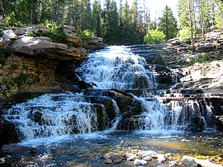
The Provo River is located in Utah County and Wasatch County, Utah, in the United States. It rises in the Uinta Mountains at Wall Lake and flows about 71 miles (114 km) southwest to Utah Lake at the city of Provo, Utah.

Stream restoration or river restoration, also sometimes referred to as river reclamation, is work conducted to improve the environmental health of a river or stream, in support of biodiversity, recreation, flood management and/or landscape development.
The Water Resources Development Act of 1996 is part of Pub. L.Tooltip Public Law 104–303 (text)(PDF), was enacted by Congress of the United States on October 12, 1996. Most of the provisions of WRDA 1996 are administered by the United States Army Corps of Engineers.
The Water Resources Development Act of 1999, Pub. L.Tooltip Public Law 106–53 (text)(PDF), was enacted by Congress of the United States on August 17, 1999. Most of the provisions of WRDA 1999 are administered by the United States Army Corps of Engineers.
The Water Resources Development Act of 2000, Pub. L.Tooltip Public Law 106–541 (text)(PDF), was enacted by Congress of the United States on December 11, 2000. Most of the provisions of WRDA 2000 are administered by the United States Army Corps of Engineers.

Wetland conservation is aimed at protecting and preserving areas of land including marshes, swamps, bogs, and fens that are covered by water seasonally or permanently due to a variety of threats from both natural and anthropogenic hazards. Some examples of these hazards include habitat loss, pollution, and invasive species. Wetland vary widely in their salinity levels, climate zones, and surrounding geography and play a crucial role in maintaining biodiversity, ecosystem services, and support human communities. Wetlands cover at least six percent of the Earth and have become a focal issue for conservation due to the ecosystem services they provide. More than three billion people, around half the world's population, obtain their basic water needs from inland freshwater wetlands. They provide essential habitats for fish and various wildlife species, playing a vital role in purifying polluted waters and mitigating the damaging effects of floods and storms. Furthermore, they offer a diverse range of recreational activities, including fishing, hunting, photography, and wildlife observation.
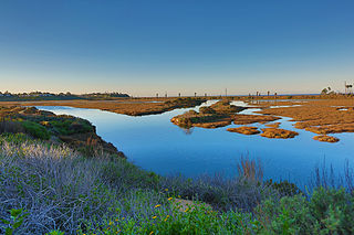
San Elijo Lagoon Ecological Reserve is one of the largest remaining coastal wetlands in San Diego County, California, United States.

The Vindel River is a river in northern Sweden. It is a tributary to Ume River and the biggest tributary river in Sweden. It lends its name to the Vindelfjällens Nature Reserve, one of the largest protected areas in Europe, totaling 562,772 ha. Since it is partially located within the reserve, it is permanently protected from hydroelectric development. Downstream from where Vindelälven merges with Umeälven Sweden's largest hydropower plant is located. Considering that the river is not unregulated all the way to the ocean, but just in the part of it formally called Vindelälven, the decision to call it "unregulated" or "permanently protected from hydropower" is to be taken with a grain of salt. The river Vindel and its tributaries were important routes for transporting timber in northern Sweden, up until 1976. To ease the movement of logs downstream, wooden dams were constructed, side streams were cut off and tributaries were straightened and cleared. These changes significantly affected the river ecosystem and populations of wild fish, mammals, mussels and other species of aquatic and riparian habitats. The changes therefore negatively impact the favourable conservation status of species and habitats within the Vindel River Natura 2000 network site. Actions to restore the tributaries of the Vindel River to a more natural state are considered a priority by the Swedish environmental protection agency, the Västerbotten county administrative board, and the EU under the Habitats Directive and the Water Framework Directive (WFD). The general objective of the Vindel River LIFE project was to achieve a ‘good status’ for the waters of the Vindel River with reference to the Water Framework Directive, and ‘good conservation status’ for the species in the project area under the Habitats Directive. The aim was to reduce the negative impacts of fragmentation and channelisation caused by timber-floating infrastructure in tributaries of the Vindel River system. The work was focused on a number of river stretches, altogether spanning just over 44 km, with the aim of removing 73% of the obstructions to natural river flow, placing large boulders and fallen trees in the water to simulate natural conditions and to reconnect streams to the tributaries to open up breeding areas for migrating fish. The Vindel River LIFE project restored streams in the tributaries of the Vindel River basin, by removing timber-floating infrastructure, replacing large obstacles into the water, and creating and restoring fish spawning grounds. These ecosystem restoration measures resulted in improved water quality, and improvements in conditions for protected species, in line with national and EU policy. The project’s work had clear socio-economic benefits in the project area.
Oyster reef restoration refers to the reparation and reconstruction of degraded oyster reefs. Environmental changes, modern fishing practices, over harvesting, water pollution, and other factors, have resulted in damage, disease, and ultimately, a large decline in global population and prevalence of oyster habitats. Aside from ecological importance, oyster farming is an important industry in many regions around the world. Both natural and artificial materials have been used in efforts to increase population and regenerate reefs.

The Interstate Commission on the Potomac River Basin (ICPRB) is an agency composed of commissioners representing the federal government, the states of Maryland, Pennsylvania, Virginia, West Virginia, and the District of Columbia. The ICPRB mission is to enhance, protect, and conserve the water and associated land resources of the Potomac River basin and its tributaries through regional and interstate cooperation.

Chicago Wilderness Alliance is a regional alliance of more than 250 different organizations that work together to improve the quality of life of the individuals and the many other species living in the Chicago (Illinois) area. Through the restoration and sustenation of the biological diversity that once encompassed the lands, their fundamental objective, to preserve the naturally occurring lands and waters in that region, is being made a reality. Through these activities, Chicago Wilderness played a major role in protecting and replenishing the naturally occurring ecosystems in the Chicago area as well as motivating people to become more aware and involved in the preservation of these lands and waters. Chicago Wilderness had continued to blossom through the funding and donations of many sources including private contributions, the member organizations, and state and federal grants.
The North Carolina Coastal Federation is a nonprofit organization that works with coastal residents and visitors to protect and restore the beautiful and productive N.C. coast. The four main areas in which the federation operates include: coastal advocacy; environmental education; habitat and water quality restoration and preservation; and support in the improvement and enforcement of environmental laws. The federation headquarters are located in Newport (Ocean), North Carolina, with regional offices in Wanchese and Wrightsville Beach, North Carolina. The federation is currently a member of Restore America's Estuaries (RAE).
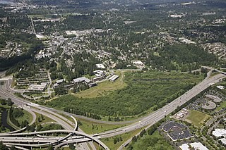
The UW Bothell/Cascadia College Wetland Restoration Project is a 58-acre forested floodplain restoration site at the delta of North Creek in King County, Washington, USA. The State of Washington bought the site in 1994 from the Truly family, and dedicated the land to the construction of the Bothell regional campus of the University of Washington and Cascadia College. Construction began in 1998, as did the stream and floodplain restoration. Two years later, in 2000, classes opened for students, and in 2001 the main phase of the restoration was completed. Today the site is an ongoing area of restoration education.

North Campus Open Space (NCOS) is a 136-acre wetland and upland restoration project (55 ha) in Goleta, California. Located on a former golf course, NCOS is managed by the Cheadle Center for Biodiversity and Ecological Restoration (CCBER), a research center under the Office of Research at the University of California, Santa Barbara (UCSB). The primary objectives of this project are: the restoration of the historic upper half of Devereux Slough and adjacent upland and wetland habitats that support important local native plant and animal species, reducing flood risk, providing a buffer against predicted sea level rise, and contributing to carbon sequestration while also supporting public access and outreach, and facilitating research and educational opportunities for all members of the community.